Jimaní facts for kids
Quick facts for kids
Jimaní
|
||
|---|---|---|
 |
||
|
||
| Country | Dominican Republic | |
| Province | Independencia | |
| Municipality since | 1945 | |
| Area | ||
| • Total | 472.5 km2 (182.4 sq mi) | |
| Elevation | 31 m (102 ft) | |
| Population | ||
| • Total | 13,752 | |
| • Density | 29.105/km2 (75.381/sq mi) | |
| • Urban | 7,155 | |
| Distance to – Santo Domingo |
280 km |
|
| Municipal Districts | 2 | |
| Climate | BSh | |
Jimaní is an important city in the Dominican Republic. It is the capital of the Independencia Province. Jimaní is special because it's one of the two main places where people can cross the border into Haiti. There's even a big outdoor market there where you can buy things without paying extra taxes!
Sadly, Jimaní was hit by a terrible flood on May 25, 2004. Many people lost their lives, and hundreds of homes were destroyed.
Contents
History of Jimaní
What's in a Name?
The name "Jimaní" comes from the native Taíno people who lived on the island long ago. A historian named Rafael Leonidas Pérez y Pérez says that "Ximani" was the name of a powerful Cacique (a native chief). This chief controlled a town located between two lakes, Lake Enriquillo and Lake Azuei. This spot was very important because it was a key pathway to a mountain called Pic la Selle.
The name "Ximaní" became well-known in 1536. This was when the Spanish signed a peace agreement with the natives at a place called "the Lagoon of Ximaní."
Another Idea for the Name
There's another idea about where the name came from. Some people say it was named after a French Count (a type of noble) called the Count of Jimaní. This general, Paul Decayette, tried to invade the Dominican Republic in 1856. However, the Dominican army stopped him. This victory helped end the long war between the Dominican Republic and Haiti.
But historian Pérez y Pérez explains that the French official was called "of Jimaní" because he owned land there. This land was given to him when the French expanded their control. The historian believes the French didn't really control this area until the mid-1700s.
Jimaní Grows as a Town
During the Dominican War of Independence, Jimaní was almost empty. Most of the fighting happened in a nearby town called Neiba. After the Dominican Republic became independent in 1844, new people started moving to Jimaní. They came from different towns in the southwest, like Neiba and Duvergé. Also, Haitian immigrants from the mountains settled there. They married Dominicans and started families, especially in the oldest part of town, known as Jimaní Viejo.
By the 1930s, Jimaní was part of Neiba. Then, in 1938, it became part of a larger area called La Descubierta, which was in the Baoruco Province.
Becoming a Capital City
On March 18, 1943, Jimaní was made a "municipal district." This meant it had its own local government. A few years later, on December 29, 1948, the Baoruco Province was split into two. The western part became the new Independencia Province. Finally, on January 1, 1950, Jimaní officially became the capital city of this new province.
Climate in Jimaní
Jimaní is located in a valley. It's in a "rain shadow," which means the mountains block most of the rain from reaching it. Because of this, Jimaní has a hot semi-arid climate. This means it's usually hot and dry, with temperatures staying pretty much the same all year.
The rain usually falls in two main periods: May and October. The driest time of year is from December to February.
| Climate data for Jimaní (1991–2020) | |||||||||||||
|---|---|---|---|---|---|---|---|---|---|---|---|---|---|
| Month | Jan | Feb | Mar | Apr | May | Jun | Jul | Aug | Sep | Oct | Nov | Dec | Year |
| Mean daily maximum °C (°F) | 32.4 (90.3) |
33.0 (91.4) |
33.5 (92.3) |
34.3 (93.7) |
34.0 (93.2) |
35.1 (95.2) |
36.1 (97.0) |
36.3 (97.3) |
35.5 (95.9) |
34.4 (93.9) |
33.2 (91.8) |
32.6 (90.7) |
34.2 (93.6) |
| Daily mean °C (°F) | 26.8 (80.2) |
27.3 (81.1) |
27.9 (82.2) |
28.8 (83.8) |
29.0 (84.2) |
30.0 (86.0) |
30.7 (87.3) |
30.8 (87.4) |
30.1 (86.2) |
29.2 (84.6) |
28.1 (82.6) |
27.1 (80.8) |
28.8 (83.8) |
| Mean daily minimum °C (°F) | 21.1 (70.0) |
21.6 (70.9) |
22.2 (72.0) |
23.3 (73.9) |
24.0 (75.2) |
24.9 (76.8) |
25.2 (77.4) |
25.3 (77.5) |
24.6 (76.3) |
24.1 (75.4) |
22.9 (73.2) |
21.6 (70.9) |
23.4 (74.1) |
| Average precipitation mm (inches) | 13.5 (0.53) |
26.4 (1.04) |
59.4 (2.34) |
82.6 (3.25) |
118.0 (4.65) |
40.5 (1.59) |
34.6 (1.36) |
60.1 (2.37) |
83.9 (3.30) |
116.2 (4.57) |
63.8 (2.51) |
21.3 (0.84) |
720.1 (28.35) |
| Source: NOAA | |||||||||||||
Economy of Jimaní
Farming and Trade
The main ways people make money in Jimaní are through farming and trading with Haiti. Farmers grow crops like cassava, sweet potatoes, melons, peppers, cilantro, and tomatoes.
The Border Market
Jimaní is famous for its "duty-free open-air marketplace" right on the border with Haiti. This market is very popular! People from nearby towns and even far away come to shop here. You can find basic foods, drinks, clothes, shoes, and even new and used electronics.
The area at the border where customs checks happen is called "The Door." Tourists often visit "The Door" to see how business works and how Dominicans and Haitians interact there.
Local Government and Money
The city government of Jimaní gets about 1,000,000 Dominican pesos (RD$) each month. This money comes from the national government through the Dominican Municipal League. The city also collects about $15,000 each month from local taxes.
Two smaller areas within the municipality, El Limón and Boca de Cachón, each receive $500,000 monthly from the national government.
There are also two places where people can do their banking in Jimaní: a branch of the Reserve Bank and a branch of the Cooperative of Savings and Credit of Neiba (Coopacrene).
Education in Jimaní
Jimaní has six elementary schools that teach students in two shifts each day. There are also four public high schools, and three of these are for adults who want to continue their education.
Culture and Religion
Most people in Jimaní are Catholic. They celebrate their local holidays on March 19, honoring their patron saint, San José. They are also adding a carnival to this celebration to make it even bigger!
Another new tradition is a "Cultural Week" held every year. This week remembers the terrible flood in May 2004 that damaged a large part of the town.
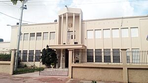
Jimaní also has a historic building called the "Mansion of Trujillo." This was one of many houses built by a former leader in the border area. It's kept in good condition as a historical and cultural landmark.
Public Works and Community Projects
The local government in Jimaní has completed several projects to help the community. They have rebuilt and improved the municipal cemetery. They've also fixed street gutters and improved the electric lighting in the city and in the Tierra Nueva area. There are also plans to make the water system bigger for the neighborhoods of La Cu and El Cerro.
Community Organizations
Jimaní has many community groups that help people. For example, in each town within the municipality, there's an Association of Farmers and an Association of Mothers.
Other organizations include:
- A Lions Club
- The Association of Minibuses Jimaní-Barahona (for transportation)
- A committee representing people from Jimaní who live in Massachusetts, USA
- A technical team from World Vision (a global charity)
- Fundasur (Foundation of the South)
- Conani (the National Council for Childhood and Adolescence), which helps children and teenagers.
See also
 In Spanish: Jimaní para niños
 | Tommie Smith |
 | Simone Manuel |
 | Shani Davis |
 | Simone Biles |
 | Alice Coachman |


