
Jincheng facts for kids
Quick facts for kids
Jincheng
晋城市
Tsincheng
|
|
|---|---|
|
Prefecture-level city
|
|

The Tower of Rivers and Mountains overlooking the House of the Huangcheng Chancellor
|
|
.png)
Location of Jincheng City jurisdiction in Shanxi
|
|

Jincheng
Location in Shanxi
|
|
| Country | People's Republic of China |
| Province | Shanxi |
| County-level divisions | 6 |
| Municipal seat | Chengqu |
| Government | |
| • Type | Prefecture-level city |
| Area | |
| • Prefecture-level city | 9,490 km2 (3,660 sq mi) |
| • Urban | 143.00 km2 (55.21 sq mi) |
| • Districts | 2,164.0 km2 (835.5 sq mi) |
| Population | |
| • Prefecture-level city | 2,279,151 |
| • Density | 240.16/km2 (622.0/sq mi) |
| • Urban | 493,000 |
| • Urban density | 3,448/km2 (8,929/sq mi) |
| • Districts | 1,067,000 |
| GDP | |
| • Prefecture-level city | CN¥ 142.6 billion US$ 22.4 billion |
| • Per capita | CN¥ 65,122 US$ 10,420 |
| Time zone | UTC+8 (China Standard) |
| Postal code |
048000
|
| Area code(s) | 0356 |
| ISO 3166 code | CN-SX-05 |
| Licence plates | 晋E |
| Administrative division code | 140500 |
| Website | www.JCOnline.cn |
|
Cedrus Lagerstroemia indica |
|
| Jincheng | |||||||||
|---|---|---|---|---|---|---|---|---|---|
| Simplified Chinese | 晋城 | ||||||||
| Traditional Chinese | 晉城 | ||||||||
| Literal meaning | Jin City | ||||||||
|
|||||||||
Jincheng is a big city in the southeast of Shanxi province, China. It's known for its industries, especially coal mining. About 2.2 million people live here. Jincheng is close to Henan province.
Because of its many factories, Jincheng used to have a lot of air pollution. But the city government is working hard to make the air cleaner. They are planting many trees, building parks, and moving factories that cause too much pollution. They also encourage using coalbed methane, which is a cleaner fuel than regular coal.
Contents
Jincheng's Long History
Jincheng has a very old and interesting history. It goes all the way back to the Warring States period (around 475-221 BC). During this time, the land where Jincheng is now was split among three powerful states: Zhao, Wei, and Han.
Ancient Battles and Changes
A very important battle, the Battle of Changping, happened near what is now Gaoping City in Jincheng. This battle was fought between the Qin and Zhao states. After the first emperor of Qin united all of China, Jincheng became part of a larger area called Shangdang Shire.
For a long time, during the Han dynasty and Wei dynasties, Jincheng stayed part of Shangdang Shire. Later, during the Sixteen Kingdoms period, Jincheng started to become its own important area. Its name changed a few times over the centuries, from Jianxing Shire to Jianzhou, then to Zezhou. Finally, during the Qing dynasty, it was called Zezhoufu. These changes helped shape the five counties that make up Jincheng today.
Modern Times
It wasn't until the Republic of China period that these old "states" were officially changed into "counties," which is how China is divided today.
Jincheng's Economy
Jincheng is rich in natural resources, especially coal. More than half of the city's land has coal underground. The coal found here is called anthracite. It's a very high-quality coal with few impurities.
Coal and Methane Resources
Jincheng has a huge amount of anthracite. It holds over a quarter of all the anthracite in China! It also has half of all the anthracite in Shanxi province. Besides coal, Jincheng also has a lot of coal mine methane. This is a cleaner type of fuel that was found in Qinshui county in 2001. Most of the coal and methane production is handled by a large company called Jincheng Anthracite Mining Group.
Other Industries
Jincheng isn't just about coal. A big factory for Foxconn is also located here. This factory makes fiber optic parts, which are used in many electronic devices and for fast internet connections. This factory produces goods worth over 3 billion Chinese Yuan each year.
Jincheng's Geography
Jincheng is located in the southeastern part of Shanxi province. The city covers a total area of 9,490 square kilometers (about 3,664 square miles). A large part of this land, about 188,920 hectares, is used for farming.
Getting Around Jincheng
You can reach Jincheng by road using China National Highway 207. There's also a railway line, the Taiyuan–Jiaozuo Railway, that connects the city. Jincheng does not have its own commercial airport. If you want to fly, the closest airports are in nearby cities like Zhengzhou, Changzhi, and Luoyang.
Jincheng's Climate
Jincheng has a climate that is influenced by monsoons. This means it has dry, cold winters and hot, humid summers. The average temperature changes a lot throughout the year. In January, the coldest month, the average temperature is about -1.9°C (28.6°F). In July, the hottest month, it's around 24.5°C (76.1°F).
Most of the rain in Jincheng falls during the summer months, from June to September. This is typical for areas affected by the East Asian Monsoon. The city gets about 576 millimeters (22.7 inches) of rain each year.
| Climate data for Jincheng, elevation 753 m (2,470 ft), (1991–2020 normals, extremes 1981–2010) | |||||||||||||
|---|---|---|---|---|---|---|---|---|---|---|---|---|---|
| Month | Jan | Feb | Mar | Apr | May | Jun | Jul | Aug | Sep | Oct | Nov | Dec | Year |
| Record high °C (°F) | 19.1 (66.4) |
24.2 (75.6) |
28.2 (82.8) |
36.9 (98.4) |
36.5 (97.7) |
38.6 (101.5) |
38.6 (101.5) |
35.8 (96.4) |
36.6 (97.9) |
32.6 (90.7) |
26.6 (79.9) |
18.7 (65.7) |
38.6 (101.5) |
| Mean daily maximum °C (°F) | 4.0 (39.2) |
7.4 (45.3) |
13.3 (55.9) |
20.2 (68.4) |
25.1 (77.2) |
28.8 (83.8) |
29.5 (85.1) |
28.1 (82.6) |
24.0 (75.2) |
18.6 (65.5) |
11.8 (53.2) |
5.7 (42.3) |
18.0 (64.5) |
| Daily mean °C (°F) | −1.9 (28.6) |
1.3 (34.3) |
6.9 (44.4) |
13.5 (56.3) |
18.9 (66.0) |
23.0 (73.4) |
24.5 (76.1) |
23.1 (73.6) |
18.6 (65.5) |
12.7 (54.9) |
5.9 (42.6) |
0.0 (32.0) |
12.2 (54.0) |
| Mean daily minimum °C (°F) | −6.4 (20.5) |
−3.3 (26.1) |
1.7 (35.1) |
7.8 (46.0) |
13.2 (55.8) |
17.7 (63.9) |
20.5 (68.9) |
19.4 (66.9) |
14.4 (57.9) |
8.0 (46.4) |
1.3 (34.3) |
−4.4 (24.1) |
7.5 (45.5) |
| Record low °C (°F) | −17.4 (0.7) |
−17.4 (0.7) |
−10.1 (13.8) |
−3.6 (25.5) |
2.9 (37.2) |
10.1 (50.2) |
13.5 (56.3) |
11.0 (51.8) |
4.4 (39.9) |
−3.6 (25.5) |
−12.6 (9.3) |
−16.6 (2.1) |
−17.4 (0.7) |
| Average precipitation mm (inches) | 9.0 (0.35) |
12.4 (0.49) |
16.5 (0.65) |
36.7 (1.44) |
49.0 (1.93) |
67.9 (2.67) |
136.6 (5.38) |
120.7 (4.75) |
71.4 (2.81) |
36.4 (1.43) |
20.6 (0.81) |
5.6 (0.22) |
582.8 (22.93) |
| Average precipitation days (≥ 0.1 mm) | 4.0 | 4.5 | 5.3 | 6.3 | 7.6 | 8.9 | 12.4 | 11.6 | 10.0 | 7.0 | 5.0 | 3.4 | 86 |
| Average snowy days | 5.0 | 4.9 | 2.7 | 0.4 | 0 | 0 | 0 | 0 | 0 | 0.1 | 2.0 | 4.0 | 19.1 |
| Average relative humidity (%) | 52 | 55 | 52 | 54 | 55 | 60 | 74 | 76 | 71 | 64 | 58 | 51 | 60 |
| Mean monthly sunshine hours | 169.4 | 168.2 | 201.2 | 228.9 | 246.6 | 226.6 | 201.5 | 194.8 | 166.8 | 176.2 | 169.8 | 175.9 | 2,325.9 |
| Percent possible sunshine | 54 | 54 | 54 | 58 | 57 | 52 | 46 | 47 | 45 | 51 | 56 | 58 | 53 |
| Source: China Meteorological Administration | |||||||||||||
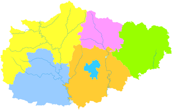
How Jincheng is Divided
Jincheng is divided into six main parts. These are one district, one city, and four counties. Each of these areas has its own population and size.
| Map of Jincheng's Divisions | |||||
|---|---|---|---|---|---|
Cheng
Zezhou
County Qinshui
County Yangcheng
County Lingchuan
County Gaoping
(city) |
|||||
| Name | Hanzi | Hanyu Pinyin | Population (2003 est.) |
Area (km2) | Density (/km2) |
| Cheng District | 城区 | Chéngqū | 280,000 | 141 | 1,986 |
| Gaoping City | 高平市 | Gāopíng Shì | 480,000 | 946 | 507 |
| Zezhou County | 泽州县 | Zézhōu Xiàn | 510,000 | 2,023 | 252 |
| Qinshui County | 沁水县 | Qìnshuǐ Xiàn | 210,000 | 2,655 | 79 |
| Yangcheng County | 阳城县 | Yángchéng Xiàn | 390,000 | 1,968 | 198 |
| Lingchuan County | 陵川县 | Língchuān Xiàn | 250,000 | 1,751 | 143 |
Images for kids
-
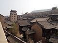
The Tower of Rivers and Mountains overlooking the House of the Huangcheng Chancellor
-
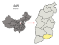
Location of Jincheng City jurisdiction in Shanxi
See also
 In Spanish: Jincheng para niños
