
John Washington (Royal Navy officer) facts for kids
Quick facts for kids
John Washington
|
|
|---|---|
 |
|
| Hydrographer of the Navy | |
| In office 29 January 1855 – 16 September 1863 |
|
| Preceded by | Sir Francis Beaufort |
| Succeeded by | Sir George Richards |
| Secretary of the Royal Geographical Society | |
| In office 23 May 1836 – 16 March 1841 |
|
| Preceded by | Alexander Maconochie |
| Succeeded by | Julian Jackson |
| Personal details | |
| Born | 1 January 1800 Crondall, Hampshire, England |
| Died | 16 September 1863 (aged 63) Le Havre, Normandy, France |
| Spouse |
Eleonora Askew (m. 1833)
|
| Occupation | Hydrographer, geographer |
| Known for |
|
| Military service | |
| Branch | |
| Service years | 1812–1863 |
| Rank | Rear admiral |
| Wars | |
John Washington (1 January 1800 – 16 September 1863) was an important officer in the Royal Navy. He became the Hydrographer of the Navy, which means he was in charge of making sea maps. He also helped start the Royal Geographical Society of London, a group that studies geography.
Contents
John Washington joined the Royal Navy in May 1812 when he was just 12 years old. He served on a ship called HMS Junon during the War of 1812 against America. He learned a lot about studying stars and magnets from a ship's Master, William Bain.
In 1814, he went to the Royal Naval Academy and finished in 1816. He then spent three years serving in North America. Later, he was a midshipman in South America. He was promoted to lieutenant in 1821 while in Chile. He even traveled across the Andes mountains and the pampas grasslands to get back to England.
After more time at sea, he spent two years traveling in France, Spain, and Italy. He learned their languages. In 1829-1830, he explored Morocco and wrote a book about his travels. He became a commander in 1833. John Washington was one of the first members of the Royal Geographical Society and worked as its secretary for five years.
Mapping the Seas
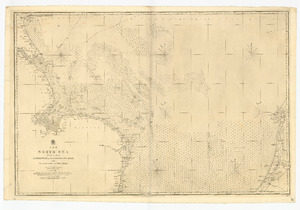
John Washington started his career in mapping the seas in 1841. He took over the survey of the North Sea after another captain, William Hewett, was lost at sea. Washington became a captain in 1842.
He continued mapping the east coast of England until 1847. One important discovery he confirmed was a spot in the North Sea where the tide doesn't rise or fall. This special spot is now called an amphidromic point. He also mapped new shipping channels, like The New Stanford Channel, which helped ships navigate safely.
Harbours and Lifeboats
Washington's work also included studying harbours. In 1844, he wrote about changes happening at Harwich harbour. He noticed that parts of the coast were washing away, which changed the currents and filled up important shipping paths. He suggested ways to fix these problems.
He was part of a group that looked into creating safe harbours where ships could go during storms. He also became a member of the Royal Society, a famous group for scientists.
In 1850, John Washington helped start a competition to design a better lifeboat. He was the head of the committee that judged the designs. The winning design was later used by the Royal National Lifeboat Institution, which saves lives at sea.

Leading the Hydrographic Office
In 1853, Washington visited Denmark, Sweden, and Russia. While there, he was asked to gather information about the Russian navy. He secretly observed their ships and collected copies of their sea maps. These maps were very useful for the British and French navies during the Crimean War that started soon after.
In 1855, John Washington became the Hydrographer of the Navy. This was a very important job, especially during wartime. His first big task was to make sure enough sea maps were available for the British and French navies. They printed many more maps than before.
After the war, Washington focused on making and selling maps to the public. He made the process faster by letting other naval assistants check the maps before they were published. He also improved how maps were printed and sold. By 1864, there were 2,500 different maps listed, and sales went up.
He also started new projects, like mapping the deep sea for laying long-distance telegraph cables. These cables would allow messages to be sent across oceans.
Washington also made a big change for naval officers called "Masters." These were skilled navigators, but they weren't considered full officers. Washington helped create a new officer rank for them, which was a big step forward for their careers. He also helped David Livingstone with his famous Zambezi expedition, providing people and boats.
Later Years and Legacy
John Washington was promoted to rear-admiral in 1862. The next year, he became ill and traveled to France. He passed away in Le Havre, France, in September 1863. Many people believed his illness was caused by working too hard and stress. His funeral was attended by many people, showing how much he was respected.
John Washington's work greatly improved how the Royal Navy mapped the seas and helped make sea travel safer for everyone.
Images for kids
-
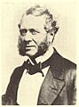
John Washington, a key figure in naval mapping.
