Jordan–Saudi Arabia border facts for kids

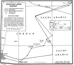
The Jordan–Saudi Arabia border is a long line that separates the countries of Jordan and Saudi Arabia. It is about 731 kilometers (454 miles) long. This border stretches from the Gulf of Aqaba in the southwest all the way to where Jordan, Saudi Arabia, and Iraq meet in the northeast.
Contents
What the Border Looks Like
The border begins at the Gulf of Aqaba. From there, it is made up of nine straight lines that mostly go towards the northeast, ending at the point where Jordan, Saudi Arabia, and Iraq meet. There's a part of the border in the north that curves inward sharply. This curved section is sometimes jokingly called "Winston's Hiccup" or "Churchill's Sneeze" (in Arabic, حازوقة وينستون).
A Look at History
How the Border Came to Be
At the start of the 1900s, the Ottoman Empire controlled the area that is now Jordan. The lands further south were home to different Arab groups. The most important of these was the Emirate of Nejd and Hasa, ruled by the al-Saud family. During World War I, a big Arab Revolt happened. With help from Britain, the Ottomans were pushed out of most of the Middle East.
After the war, a leader named Ibn Saud greatly expanded his kingdom. Eventually, he created the Kingdom of Saudi Arabia in 1932.
Britain and France had a secret plan called the Sykes-Picot Agreement in 1916. This plan gave Britain control over the southern part of the Ottoman region called Syria Vilayet. France got the northern part. The southern part, which is now western Jordan, was a bit chaotic. Different groups, like Britain, the new Arab Kingdom of Syria, the Kingdom of Hejaz, and Zionists in Mandatory Palestine, all wanted control. For a while, it was an ungoverned area.
In 1921, Britain officially took control of the region. They created the Emirate of Transjordan, which was led by Emir Abdullah I. He had some self-rule.
Getting Access to the Sea
Having a southern border was very important for Transjordan. It needed access to the sea through the Port of Aqaba so it wouldn't be landlocked. The southern area of Ma'an-Aqaba was a large region with few people. It was managed by different groups and claimed by the Kingdom of Hejaz.
After the Saudi conquest of Hejaz in 1924–25, the army of Hussein (the ruler of Hejaz) went to the Ma'an region. Transjordan then officially added this area to its territory. In 1925, Britain and Ibn Saud signed the Treaty of Hadda. This treaty set up a border between Jordan and Saudi Arabia using six straight lines. This was a key moment because it gave Transjordan a short coastline on the Gulf of Aqaba. The border was later confirmed by the 1927 Treaty of Jeddah.
In the early 1960s, Jordan and Saudi Arabia talked about their border again. They signed a new treaty on August 9, 1965. This treaty created the current border, which has nine lines. It also gave Jordan a slightly longer coastline (about 18 kilometers more) along the Gulf of Aqaba.
The Story of 'Winston's Hiccup'
The idea of the 'Winston Hiccup' is a popular story, but it's mostly a myth. It comes from a story about Winston Churchill. He was a British politician who later became Prime Minister. When he was older, he supposedly joked that he created the British area of Transjordan in 1921 "with the stroke of a pen, one Sunday afternoon in Cairo". Some versions of the story even say he did this after a big lunch!
However, this story is likely a misunderstanding. Churchill was in Jerusalem for a meeting in March 1921. He did say that he put Emir Abdullah in Transjordan "one Sunday afternoon at Jerusalem." But the borders between Transjordan and the Sultanate of Nejd (which became Saudi Arabia) were not actually discussed at that meeting.
The "hiccup" part of the border was first drawn in October 1922. This happened during a visit by Emir Abdullah to London. The official border between Transjordan and Nejd was decided through talks between the British Government and the Sultan of Nejd. These talks started in 1922 and ended with the Al Hadda Agreement on November 2, 1925. Churchill was not involved in this agreement.
The "hiccup" happened because the strategic Wadi Sirhan region, including the town of Kaf, was given to the Sultanate of Nejd. This area had been occupied by Abdullah's forces at Britain's request. The 1925 treaty didn't create the sharp triangle we see today. Instead, it made a short north-south line.
Towns Near the Border
In Jordan
- Mudawwara
In Saudi Arabia
- Halat Ammar
- Al Fiyad
- Al Isawiyah
- Qurayyat
- Qullayib Khudr
- An Nabk
- Al-Haditha
- Turaif
Border Crossings
There are three official places where people can cross the border:
- Umari
- Mudawwara
- Durra Border Crossing
See also
- Al Harrah, Saudi Arabia
- Al Jawf Province
- Amman Governorate
- Azraq
- British Mandate of Palestine
- Geography of Jordan
- Jordan-Saudi Arabia relations
- Geography of Saudi Arabia
- Zarqa Governorate


