
Kaisten, Aargau facts for kids
Quick facts for kids
Kaisten
|
||
|---|---|---|

Ittenthal
|
||
|
||

Kaisten
Location in Switzerland

Kaisten
Location in Canton of Aargau
|
||
| Country | Switzerland | |
| Canton | Aargau | |
| District | Laufenburg | |
| Area | ||
| • Total | 18.09 km2 (6.98 sq mi) | |
| Elevation | 335 m (1,099 ft) | |
| Population
(Dec 2020 )
|
||
| • Total | 2,754 | |
| • Density | 152.24/km2 (394.30/sq mi) | |
| Postal code |
5082
|
|
| Surrounded by | Eiken, Frick, Ittenthal, Laufenburg (DE-BW), Laufenburg, Murg (DE-BW), Oeschgen, Sisseln, Sulz | |

Kaisten is a small town, also called a municipality, in Switzerland. It is located in the Laufenburg district, which is part of the canton of Aargau. On January 1, 2010, another nearby town called Ittenthal joined with Kaisten.
Contents
History of Kaisten
Kaisten has a long and interesting history! People have lived here for a very long time.
Ancient Times in Kaisten
Archaeologists have found old items in Kaisten. These include a Bronze Age burial mound. A burial mound is like a small hill built over a grave. This one was from the Hallstatt culture, an ancient group of people. They also found a Roman watchtower and a place where bricks were made.
First Mentions and Early Rule
Kaisten was first written about in the year 1282. It was called Keiston back then. Ittenthal, the town that later joined Kaisten, was mentioned in 1297. A castle was built in Kaisten between the 12th and 13th centuries. It was part of the land controlled by Säckingen. After the 13th century, the Habsburgs took over. They were a powerful family who ruled much of Europe. Kaisten remained under their control until 1797.
Becoming a Municipality
In 1803, the area called Fricktal became part of the Aargau canton. This happened because of something called the Act of Mediation. After this, Kaisten officially became its own municipality.
Church History
The Church of St. Michael in Kaisten was first mentioned in 1443. It was founded by Säckingen. Until 1804, it was a "filial church." This means it was a smaller church connected to the main church in Laufenburg. The church building you see today was built in 1717. Before 1812, Kaisten and Ittenthal shared a "parish," which is an area served by one church.
Economy Through the Ages
For a long time, growing grapes for wine was very important in Kaisten. This lasted until the mid-1800s. In the Middle Ages and early modern times, people also worked with iron. They would melt it down, which is called smelting. In the 20th century, a factory that made bricks was built in Kaisten. Until about 1960, Kaisten was mostly a farming village. After that, it started to focus more on the chemicals industry.
Geography of Kaisten
Kaisten covers an area of about 14.19 square kilometers (about 5.48 square miles). A big part of this land is used for farming, about 41.3%. Forests cover an even larger part, about 45.0% of the area.
About 11.4% of Kaisten's land has buildings or roads on it. A small part, 2.1%, is made up of rivers or lakes. Only a tiny bit, 0.1%, is land that can't be used for anything.
Most of the built-up area is for homes and buildings (4.4%) or roads (3.5%). Industrial buildings make up 1.3%. The forests are mostly dense woods (43.0%). Some areas have orchards or small groups of trees (2.0%). For farming, 24.5% is used for crops, and 15.2% is for pastures where animals graze.
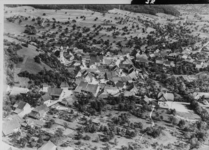
Kaisten is located in the Laufenburg district. It's in the upper part of the Fricktal, which is a valley along the Frick river. The town itself is a "haufendorf" village. This means it's an irregular, unplanned village with houses built close together around a central area. Kaisten also includes the small village of Oberkaisten and the former municipality of Ittenthal.
Kaisten's Coat of Arms
The blazon (which is a special description of a coat of arms) for Kaisten is: Or a Vine Leaf Gules slipped. This means the background is gold (Or), and there's a red (Gules) vine leaf with its stem (slipped).
People of Kaisten (Demographics)
Kaisten has a population of about 2,257 people. As of June 2009, about 14.7% of the people living in Kaisten are from other countries. Over the past 10 years (1997–2007), the number of people living here has grown by 14.1%.
Languages Spoken
Most people in Kaisten speak German, about 93.0% of the population. Italian is the second most common language (1.5%), and Albanian is the third (1.5%).
Age Groups
Here's a look at the different age groups in Kaisten (as of 2008):
- Children (0-9 years old): 10.8%
- Teenagers (10-19 years old): 14.0%
- Young adults (20-29 years old): 10.1%
- Adults (30-39 years old): 13.5%
- Adults (40-49 years old): 18.6%
- Adults (50-59 years old): 12.9%
- Seniors (60-69 years old): 10.6%
- Seniors (70-79 years old): 6.7%
- Seniors (80-89 years old): 2.5%
- Seniors (90 and older): 0.4%
Homes and Households
In 2000, the average number of people per living room was 0.57. This is similar to the average for the whole canton. About 62% of the homes were owned by the people living in them. This means they didn't pay rent, though they might have a mortgage.
In 2000, there were 771 private homes and apartments in Kaisten. On average, there were 2.6 people living in each home. In 2008, 54.0% of all homes were single-family houses. There were only 8 empty apartments, which is a very low vacancy rate of 0.9%.
Politics and Elections
In the 2007 federal election, the most popular political party was the SVP. They received 27.7% of the votes. Other popular parties were the CVP (23.9%), the SP (19.7%), and the FDP (14.6%).
Education in Kaisten
People in Switzerland generally have a good education. In Kaisten, about 73% of adults (aged 25–64) have finished either high school or gone on to higher education, like university. In the 2008/2009 school year, there were 188 students in primary school and 117 students in secondary school in Kaisten.
Historical Population
Here's how the population of Kaisten and Ittenthal has changed over time:
| year | population (Kaisten) |
population (Ittenthal) |
|---|---|---|
| 1803 | 875 | 171 |
| 1850 | 1,189 | 265 |
| 1900 | 994 | 217 |
| 1950 | 1,160 | 221 |
| 2000 | 2,054 | 222 |
Sights to See
The village of Ittenthal, which is now part of Kaisten, is recognized as an important Swiss Heritage Site. This means it has special historical or cultural value.
Economy of Kaisten
In 2007, the unemployment rate in Kaisten was low, at 1.96%. This means very few people who wanted to work couldn't find a job.
Jobs in Kaisten
In 2005, people in Kaisten worked in different types of jobs:
- Primary Sector: 94 people worked in this sector, which includes farming and forestry. There were about 30 businesses in this area.
- Secondary Sector: 516 people worked in this sector, which includes manufacturing and construction. There were 19 businesses.
- Tertiary Sector: 176 people worked in this sector, which includes services like shops, schools, and healthcare. There were 45 businesses.
In 2000, 1,015 workers lived in Kaisten. About 71.3% of them worked outside Kaisten. However, 344 people came into Kaisten for work. There were a total of 635 jobs in the municipality. Of the people who worked, 16.7% used public transportation to get to their jobs, and 48% used a private car.
Religion in Kaisten
Based on the 2000 census, most people in Kaisten are Christian. About 63.2% were Roman Catholic. Another 19.2% belonged to the Swiss Reformed Church. A small number of people, about 0.49%, belonged to the Christian Catholic faith.
See also
 In Spanish: Kaisten para niños
