Kakospictikweak River facts for kids
Quick facts for kids Kakospictikweak |
|
|---|---|

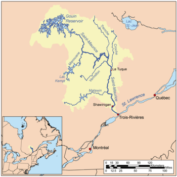
Map of Saint-Maurice watershed.
|
|

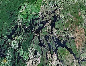
Map of Gouin Reservoir seen from space
|
|
| Country | Canada |
| Province | Quebec |
| Region | Nord-du-Québec and Mauricie |
| Physical characteristics | |
| Main source | Unidentified Lake Eeyou Istchee Baie-James (municipality), Nord-du-Québec, Quebec 484 m (1,588 ft) 49°02′24″N 74°38′28″W / 49.04000°N 74.64111°W |
| River mouth | Gouin Reservoir La Tuque, Mauricie, Quebec 402 m (1,319 ft) 48°46′38″N 74°45′09″W / 48.77722°N 74.75250°W |
| Length | 44.4 km (27.6 mi) |
| Basin features | |
| Tributaries |
|
The Kakospictikweak River is a river in Quebec, Canada. It flows into the northern part of the Gouin Reservoir. This river is important for the areas it flows through, which are in the Nord-du-Québec and Mauricie regions.
The main activities in this river valley are forestry (cutting down trees for wood) and tourism (people visiting for fun). A special forest road helps people get around the valley. This road connects to Route 400, which goes around the northeastern part of the Gouin Reservoir. It also links to the villages of Parent, Quebec and Wemotaci.
The Kakospictikweak River is usually frozen from mid-November until the end of April. It's generally safe to travel on the ice from early December to the end of March.
Contents
Where the River Flows
The Kakospictikweak River is surrounded by many other lakes and rivers.
- To the north, you'll find Compton Lake, Nemegousse Lake, Cawcot River, and Caopatina Lake.
- To the east are Dubois Lake, Normandin Lake (Normandin River), Normandin River, and Buade Lake (Normandin River).
- To the south is the large Gouin Reservoir.
- To the west are the Mathieu River, Toussaint River, Baptiste Lake, Larouche Lake, De La Rencontre Creek, and Pascagama River.
The Kakospictikweak River starts from a small, unnamed lake. This lake is located in the Pfister area of Eeyou Istchee James Bay. The lake is about 0.5 kilometres (0.31 mi) long and sits at an altitude of 484 metres (1,588 ft).
The river's starting point is:
- About 30.4 kilometres (18.9 mi) north of where the Kakospictikweak River joins Omina Lake (which connects to the Gouin Reservoir).
- About 48.3 kilometres (30.0 mi) north of the village of Obedjiwan, Quebec.
- About 86.1 kilometres (53.5 mi) northwest of the dam at the end of the Gouin Reservoir.
- About 225.8 kilometres (140.3 mi) northwest of the city of La Tuque.
From its start, the Kakospictikweak River flows for about 44.4 kilometres (27.6 mi). Let's look at its journey:
Upper Part of the River
The first part of the Kakospictikweak River is about 22.7 kilometres (14.1 mi) long.
- It flows northeast, going through a small unnamed lake.
- Then it turns southwest, flowing around a mountain and through another unnamed lake.
- It continues southwest, crossing another unnamed lake.
- The river then reaches the eastern border of Balete, which is also the boundary between La Tuque and Eeyou Istchee Baie-James.
- It flows southwest through Balete, crossing Wawackeciw Lake for about 2.3 kilometres (1.4 mi).
- Finally, it flows south, passing east of Baptiste Lake and through Piresiw Lake. Here, it meets the border between Balete and Mathieu.
Lower Part of the River
The second part of the Kakospictikweak River is about 21.7 kilometres (13.5 mi) long.
- It flows southeast, crossing a forest road. Here, the Pokotciminikew River joins it from the north.
- It continues south, picking up water from Kikikwapiskok Lake, until it reaches Kaatcipekinikatek Lake.
- The river flows south through all of Kaatcipekinikatek Lake. This lake also gets water from "Froid Lake" on its east side.
- It then flows southwest, crossing Natowew Lake. It passes under the road bridge of Route 212.
- The river makes a small turn to the east before finally joining the Gouin Reservoir.
Where the River Ends
The Kakospictikweak River flows into a bay at the bottom of Omina Lake, which is part of the Gouin Reservoir. This bay is about 5.8 kilometres (3.6 mi) long.
From this bay, the river's water flows southeast through the Gouin Reservoir. It goes around many islands and passes through Kikendatch Bay until it reaches the Gouin Dam. After the dam, the water flows into the Saint-Maurice River. The Saint-Maurice River then continues all the way to Trois-Rivières, where it joins the mighty St. Lawrence River.
River's Name
The name "Rivière Kakospictikweak" was officially recognized on September 6, 1984, by the Commission de toponymie du Québec. This is the organization in Quebec that names places.
 | Calvin Brent |
 | Walter T. Bailey |
 | Martha Cassell Thompson |
 | Alberta Jeannette Cassell |

