Kamas, Utah facts for kids
Quick facts for kids
Kamas, Utah
|
|
|---|---|
 |
|

Location in Summit County and the state of Utah
|
|
| Country | United States |
| State | Utah |
| County | Summit |
| Settled | 1859 |
| Named for | Camassia quamash |
| Area | |
| • Total | 3.69 sq mi (9.54 km2) |
| • Land | 3.69 sq mi (9.54 km2) |
| • Water | 0.00 sq mi (0.00 km2) |
| Elevation | 6,690 ft (2,040 m) |
| Population
(2010)
|
|
| • Total | 1,811 |
| • Density | 617.64/sq mi (238.50/km2) |
| Time zone | UTC-7 (Mountain (MST)) |
| • Summer (DST) | UTC-6 (MDT) |
| ZIP code |
84036
|
| Area code(s) | 435 |
| FIPS code | 49-39810 |
| GNIS feature ID | 2410162 |
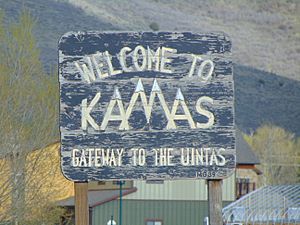
Kamas is a city in Summit County, Utah, in the United States. About 1,800 people lived there in 2010. It is about 42 miles (68 km) east of Salt Lake City. Kamas is known for its cattle ranching and lumber industries. People often call it "The Gateway to the Uinta Mountains" because it's close to these beautiful mountains.
Contents
History of Kamas
The name Kamas comes from a flowering plant called Camassia quamash. This plant grows in the area. Native Americans used it as a food source long ago.
Different Native American groups lived in the Kamas Valley over time. These included parts of the Ute, Shoshone, and Snake tribes. The first people to settle here permanently were Mormon pioneers. They arrived around 1859, led by Brigham Young. Some of these early settlers were Abraham Marchant, John Lambert, and John Pack.
There's a famous story in Kamas about a man named Thomas Rhoads. Legend says that guides from the local Ute Tribe showed Rhoads a secret gold mine. He was allowed to take gold from this mine to help build the Salt Lake Temple. The Ute guides made him promise not to tell anyone else about the mine. Rhoads kept his promise until he died. The "Rhoads Mine" is now considered lost, but its story is still told in books.
Geography and Climate
Kamas is a city built entirely on land, covering about 1.6 square miles (4.1 km²).
Kamas Weather
Kamas has a climate with warm summers and cold winters. This type of weather is called a "warm-summer humid continental climate." The hottest temperature ever recorded in Kamas was 101°F (38°C) on July 13, 2002. The coldest temperature was -31°F (-35°C) on December 21, 1990.
| Climate data for Kamas, Utah, 1991–2020 normals, extremes 1949–present | |||||||||||||
|---|---|---|---|---|---|---|---|---|---|---|---|---|---|
| Month | Jan | Feb | Mar | Apr | May | Jun | Jul | Aug | Sep | Oct | Nov | Dec | Year |
| Record high °F (°C) | 59 (15) |
62 (17) |
76 (24) |
84 (29) |
92 (33) |
97 (36) |
101 (38) |
98 (37) |
95 (35) |
85 (29) |
75 (24) |
62 (17) |
101 (38) |
| Mean maximum °F (°C) | 50.0 (10.0) |
53.2 (11.8) |
63.6 (17.6) |
73.3 (22.9) |
81.7 (27.6) |
88.9 (31.6) |
93.8 (34.3) |
92.3 (33.5) |
86.6 (30.3) |
76.6 (24.8) |
63.6 (17.6) |
52.0 (11.1) |
94.7 (34.8) |
| Mean daily maximum °F (°C) | 34.8 (1.6) |
38.2 (3.4) |
47.2 (8.4) |
55.4 (13.0) |
65.3 (18.5) |
76.2 (24.6) |
84.5 (29.2) |
82.9 (28.3) |
73.6 (23.1) |
59.2 (15.1) |
44.7 (7.1) |
34.4 (1.3) |
58.0 (14.5) |
| Daily mean °F (°C) | 25.0 (−3.9) |
27.8 (−2.3) |
35.9 (2.2) |
42.6 (5.9) |
50.8 (10.4) |
59.4 (15.2) |
67.1 (19.5) |
65.8 (18.8) |
57.2 (14.0) |
45.2 (7.3) |
33.7 (0.9) |
25.0 (−3.9) |
44.6 (7.0) |
| Mean daily minimum °F (°C) | 15.2 (−9.3) |
17.4 (−8.1) |
24.7 (−4.1) |
29.8 (−1.2) |
36.3 (2.4) |
42.7 (5.9) |
49.8 (9.9) |
48.7 (9.3) |
40.7 (4.8) |
31.2 (−0.4) |
22.8 (−5.1) |
15.6 (−9.1) |
31.2 (−0.4) |
| Mean minimum °F (°C) | −6.6 (−21.4) |
−3.3 (−19.6) |
6.3 (−14.3) |
15.4 (−9.2) |
23.5 (−4.7) |
30.6 (−0.8) |
38.9 (3.8) |
37.5 (3.1) |
26.2 (−3.2) |
14.9 (−9.5) |
2.0 (−16.7) |
−5.8 (−21.0) |
−10.8 (−23.8) |
| Record low °F (°C) | −26 (−32) |
−30 (−34) |
−11 (−24) |
4 (−16) |
13 (−11) |
22 (−6) |
29 (−2) |
24 (−4) |
16 (−9) |
−5 (−21) |
−18 (−28) |
−31 (−35) |
−31 (−35) |
| Average precipitation inches (mm) | 1.79 (45) |
1.34 (34) |
1.46 (37) |
1.55 (39) |
1.66 (42) |
0.95 (24) |
0.82 (21) |
1.08 (27) |
1.52 (39) |
1.60 (41) |
1.38 (35) |
1.49 (38) |
16.64 (422) |
| Average snowfall inches (cm) | 22.1 (56) |
17.9 (45) |
12.3 (31) |
7.4 (19) |
2.2 (5.6) |
0.3 (0.76) |
0.0 (0.0) |
0.0 (0.0) |
0.5 (1.3) |
2.3 (5.8) |
13.4 (34) |
18.5 (47) |
96.9 (245.46) |
| Average extreme snow depth inches (cm) | 15.8 (40) |
15.8 (40) |
10.0 (25) |
2.1 (5.3) |
0.3 (0.76) |
0.0 (0.0) |
0.0 (0.0) |
0.0 (0.0) |
0.3 (0.76) |
1.4 (3.6) |
6.3 (16) |
9.8 (25) |
17.5 (44) |
| Average precipitation days (≥ 0.01 in) | 9.6 | 8.6 | 8.5 | 8.9 | 8.3 | 5.2 | 5.3 | 6.0 | 6.2 | 7.5 | 7.3 | 7.9 | 89.3 |
| Average snowy days (≥ 0.1 in) | 8.7 | 7.5 | 4.8 | 3.7 | 0.9 | 0.0 | 0.0 | 0.0 | 0.1 | 1.1 | 4.5 | 7.2 | 38.5 |
| Source 1: NOAA | |||||||||||||
| Source 2: National Weather Service | |||||||||||||
People of Kamas
| Historical population | |||
|---|---|---|---|
| Census | Pop. | %± | |
| 1900 | 440 | — | |
| 1910 | 418 | −5.0% | |
| 1920 | 563 | 34.7% | |
| 1930 | 558 | −0.9% | |
| 1940 | 729 | 30.6% | |
| 1950 | 721 | −1.1% | |
| 1960 | 749 | 3.9% | |
| 1970 | 806 | 7.6% | |
| 1980 | 1,064 | 32.0% | |
| 1990 | 1,061 | −0.3% | |
| 2000 | 1,274 | 20.1% | |
| 2010 | 1,811 | 42.2% | |
| 2019 (est.) | 2,276 | 25.7% | |
| U.S. Decennial Census | |||
Kamas is part of the larger Salt Lake City metropolitan area. This means it's connected to the bigger city area.
In 2000, there were 1,274 people living in Kamas. Most people were White (96.31%). About 5.89% of the population was Hispanic or Latino.
Many households in Kamas had children under 18 (41.8%). Most families were married couples living together (58.2%). The average household had about 2.86 people. The average family had about 3.37 people.
The median age in Kamas was 30 years old. This means half the people were younger than 30 and half were older.
Religion in Kamas
Like many towns in rural Utah, the main religion in Kamas is the Church of Jesus Christ of Latter-day Saints. However, there is also the Kamas Bible Church. A small number of Catholic people live in Kamas and attend church in nearby Heber City or Park City.
Schools in Kamas
Kamas is part of the South Summit School District. The city is home to all the district's main schools. These include:
- South Summit High School
- South Summit Middle School
- South Summit Elementary School
Students from nearby towns like Peoa, Oakley, Marion, Francis, and Woodland also go to these schools. Students from Weber Canyon and Mirror Lake Canyon are also part of this school district.
Fun Events in Kamas
Kamas hosts several exciting events throughout the year:
- High Uintas Classic: This is a two-day bicycle race held every summer, usually in mid-June. Cyclists ride from downtown Kamas, over Bald Mountain Pass, and into Wyoming. Parts of the Tour of Utah cycling race have also passed through Kamas.
- Fiesta Days: This is a big community celebration around July 24. This date is Pioneer Day in Utah. Fiesta Days includes fun activities like rodeos, a demolition derby (where cars crash into each other!), a parade, and a beauty/scholarship pageant called Miss Fiesta Days.
- High Country Classic: This is a wrestling tournament that takes place every January.
Getting Around Kamas
High Valley Transit provides bus service in Kamas. Route 102 connects Kamas to Park City. There are three bus trips in the morning and three in the afternoon.
Famous People from Kamas
- Clark E. Bronson (born 1939) - A talented sculptor.
- Steve Schmidt (born 1970) - A well-known political and business strategist.
See also
 In Spanish: Kamas (Utah) para niños


