Kapolei, Hawaii facts for kids
Quick facts for kids
Kapolei
|
|
|---|---|
| Kapolei | |

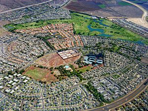
Aerial photo of Kapolei neighborhood
|
|
| Nickname(s):
The Second City of Oʻahu, Hawaiʻi's e-City
|
|
| Country | United States |
| State | Hawaiʻi |
| County | Honolulu |
| Area | |
| • Total | 4.37 sq mi (11.32 km2) |
| • Land | 4.37 sq mi (11.32 km2) |
| • Water | 0.00 sq mi (0.00 km2) |
| Elevation | 51 ft (16 m) |
| Population
(2020)
|
|
| • Total | 21,411 |
| • Density | 4,900.66/sq mi (1,892.00/km2) |
| Time zone | UTC-10 (Hawaiʻi-Aleutian (HST)) |
| ZIP code |
96707
|
| Area code(s) | 808 |
| FIPS code | 15-30300 |

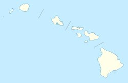
Kapolei is a planned community in Honolulu County, Hawaiʻi. It is located on the island of Oʻahu. Many people call it the "second city" of Oʻahu. This is because Honolulu is the main city. For official statistics, the U.S. Census Bureau calls Kapolei a "census-designated place" (CDP). This means it's a specific area grouped for population counting.
The community's name comes from a volcanic hill. This hill is called Puʻu o Kapolei. In the Hawaiian language, puʻu means "hill." Kapo lei means "beloved Kapo." According to old stories, Kapo was the Goddess of Fertility. She was the sister of Pele, the Goddess of Fire.
Much of the land in Kapolei used to belong to James Campbell. He was a very successful businessman. Kapolei Property Development is the main company building Kapolei. This company is part of James Campbell Company. Kapolei was built on land that used to be sugarcane and pineapple fields.
Contents
Discover Kapolei's Population
Kapolei has grown quite a bit over the years. In 2010, about 15,186 people lived there. By 2020, the population grew to 21,411 people. This shows how quickly the area is developing.
In 2020, there were 21,411 people living in Kapolei. There were also 6,583 homes. The population density was about 4,900 people per square mile. This means many people live close together.
The median age in Kapolei was 32.7 years old. About 30.6% of the people were under 18 years old. This includes 7.7% who were under 5. About 9.2% of the population was 65 or older. The community has a good mix of different age groups.
Kapolei's History and Growth
The idea for Kapolei as a planned city started a long time ago. In 1955, the first plan was made. It was updated several times, starting in 1974. In 1977, a new plan called Kapolei the "second urban center" (SUC) of Oʻahu.
Building homes in Kapolei began in the late 1980s. Businesses started to open soon after. By 2006, Kapolei had over 800 companies and organizations. These businesses created about 25,000 jobs.
The original goals for Kapolei were to make it a "smart city." This meant it would be a great place to live and work. The city aimed to have:
- A place for many jobs and businesses.
- Offices for the government.
- A city where people could easily walk, bike, or use buses.
- New energy-saving technologies, like water recycling.
- Good ways to get around Oʻahu.
The design of Kapolei follows seven main ideas. These ideas help guide its growth. They include:
- Hawaiian Garden City (making it green and beautiful).
- Healthy Living (encouraging a healthy lifestyle).
- Complete Community Services (having everything people need).
- Pedestrian-friendly (easy to walk around).
- Past/Present/Future design (mixing old and new styles).
- Sustainability (being good for the environment).
- Technology (using modern tech).
Kapolei is becoming a very important center on Oʻahu. This island is the most crowded in Hawaiʻi. Much of Oʻahu's future population growth is expected to happen in Kapolei.
Neighboring Communities
Kapolei is surrounded by other interesting communities. These include:
- Makakilo: Another census-designated place nearby.
- Kalaeloa: This area used to be a naval air station.
- Campbell Industrial Park: A large industrial area. It has Barbers Point Harbor, which is Hawaiʻi's second-biggest deepwater port.
- Ko Olina: A resort and marina community. It includes the Disney Aulani Resort and the Ko Olina Golf Club.
Getting Around Kapolei
Traffic can be a challenge in Kapolei. However, new roads are being built to help. For example, a road extension was finished in 2006. This helped reduce traffic on other main roads. More road projects are also underway.
Many adults in Kapolei work in Honolulu. This means the main highway, Interstate H-1, gets very busy. To help with this, the Honolulu City Council approved the Skyline project. This is an elevated rail system. It connects Kapolei to Downtown Honolulu. Construction began in 2011. The first part of the rail system opened in June 2023.
Main Roads in Kapolei
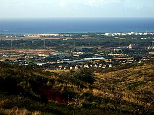
Kapolei is located near the Waiʻanae mountains. It's about 25 miles (40 km) from Honolulu.
- Fort Barrette Road connects Kapolei to Makakilo.
- The Interstate H-1 freeway goes through Kapolei. Going east on H-1 leads to Waipahu.
- West of Kapolei, H-1 merges into Farrington Highway (State Route 93). This road goes to Nānākuli on the Waiʻanae Coast.
- Kalaeloa Boulevard is an important exit from H-1. It leads to Barbers Point and Campbell Industrial Park.
- Renton Road connects Kapolei to Kalaeloa and ʻEwa Villages.
Kapolei's Economy
Kapolei has a growing economy. A big part of this is Ka Makana Ali‘i. This is a large shopping mall. It opened in October 2016. The mall has 1.4 million square feet of shops. It has over a hundred stores, including a Macy's Department Store.
Kapolei's Climate
Kapolei has a warm and pleasant climate. Here are some interesting facts about its weather:
- The highest temperature ever recorded was 96°F (36°C) in August 2016.
- The lowest temperature ever recorded was 49°F (9°C) in March 2005.
- In July, the average high temperature is 88°F (31°C). The average low is 69°F (21°C).
- In December, the average high temperature is 80°F (27°C). The average low is 60°F (16°C).
- July usually has no rainfall.
- December typically gets about 3.1 inches (79 mm) of rain.
Schools and Learning in Kapolei
The Hawaii Department of Education runs the public schools in Kapolei.
- Public elementary schools include Kapolei Elementary School and Hoʻokele Elementary School.
- Kapolei Middle School is the public middle school.
- Kapolei High School is the public high school.
There are also private schools in Kapolei:
- Island Pacific Academy teaches students from pre-kindergarten to 12th grade. It opened in 2004. It is an International Baccalaureate (IB) school.
- American Renaissance Academy opened in 2007 in Kalaeloa.
Several colleges and universities are also in Kapolei:
- The University of Hawaiʻi – West Oʻahu moved to Kapolei in August 2012.
- Hawaii Tokai International College moved to Kapolei in April 2015.
- Wayland Baptist University also has a campus in Kapolei.
See also
 In Spanish: Kapolei (Hawái) para niños
 | James B. Knighten |
 | Azellia White |
 | Willa Brown |


