Karlgarin, Western Australia facts for kids
Quick facts for kids KarlgarinWestern Australia |
|
|---|---|

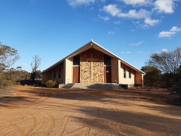
Church of Our Lady Help of Christians, Karlgarin
|
|
| Established | 1931 |
| Postcode(s) | 6358 |
| Elevation | 308 m (1,010 ft) |
| Area | [convert: needs a number] |
| Location |
|
| LGA(s) | Shire of Kondinin |
| State electorate(s) | Wagin |
| Federal Division(s) | O'Connor |
Karlgarin is a small town in Western Australia. It is located about 321 kilometers (200 miles) south-east of Perth. This area is known as the eastern Wheatbelt region. Karlgarin is a traditional farming town.
The first European to visit this area was Surveyor General John Septimus Roe. He passed through in 1848. He wrote down the name "Carlgarin" for a nearby hill. The town's name, Karlgarin, comes from the Noongar word "karl." This word means fire.
Karlgarin was chosen as a place for soldier settlements. This meant that soldiers who had served in wars could get land here. The townsite was officially named in 1931. The railway reached the area in 1930.
Contents
What People Do Here
Most people in Karlgarin work in farming. About 57% of residents work with sheep, beef cattle, and growing grains. The farms around Karlgarin produce a lot of wheat and other cereal crops.
The town has a special site called a receival site. This is where farmers bring their harvested grain. It is run by a company called Cooperative Bulk Handling.
Places to Visit
Karlgarin has a few important places. The Cooperative Bulk Handling site helps the farming industry. The town also had a school and a shop. Sadly, both were damaged in a big storm in 2013.
The main gathering place for the community is the Karlgarin Country Club. It was started in 1953. People often call it "The Club." It sells food and drinks. The club also has a bowls club, which brings in a lot of its money.
You can find different food options in Karlgarin, like a burger van. In 2015, a new cafe and art gallery opened. It is located in the old CWA building.
The Church of Our Lady Help of Christians Catholic Church is also in Karlgarin. Its first stone was placed on March 13, 1966. The old school building is on Melba Street. It opened in 1932 but closed in 2005.
Sports and Fun
Karlgarin has a small cricket oval. It is located behind the Cooperative Bulk Handling site. A combined cricket team from Karlgarin and Pingaring uses it.
The town also shares a football team with Hyden. This team is called the Hyden/Karlgarin Football Club. They play in the Eastern Districts Football League. Karlgarin also shares hockey and netball teams with Hyden.
Tourism and Local Events
Karlgarin is famous for its yearly gilgie races. Gilgies are a type of freshwater crayfish. The town is also close to Hyden and Wave Rock. Wave Rock is a very popular natural attraction.
Because of its location on the Brookton Highway, Karlgarin has good potential for tourism. To help with this, the Trestrail family opened Tressie's Museum and Caravan Park.
The Big Storm of 2013
A very strong storm hit Karlgarin on January 16, 2013. It brought heavy rain and winds up to 90 kilometers per hour (56 miles per hour). Only 25 millimeters (1 inch) of rain fell. However, the strong winds pulled trees out of the ground. They also tore roofs off buildings.
The local school, general store, and church were all damaged. Twelve buildings in total were affected. The town has been working to recover since this big storm.
 | Precious Adams |
 | Lauren Anderson |
 | Janet Collins |


