Karuah River facts for kids
Quick facts for kids Karuah River |
|
|---|---|

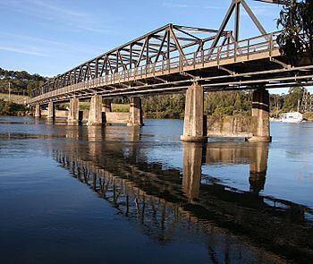
Karuah Bridge over the Karuah River at Karuah.
|
|
| Other name(s) | Karuah River Left Hand Branch, Clyde |
| Country | Australia |
| State | New South Wales |
| Region | NSW North Coast (IBRA), Mid North Coast, Hunter |
| Local government area | Mid-Coast Council |
| Town | Stroud, Karuah |
| Physical characteristics | |
| Main source | Gloucester Tops, Great Dividing Range below The Mountaineer, southwest of Gloucester 598 m (1,962 ft) |
| River mouth | Port Stephens Karuah 0 m (0 ft) |
| Length | 101 km (63 mi) |
| Basin features | |
| Tributaries |
|
The Karuah River is an important river in New South Wales, Australia. It is found in the Mid North Coast and Hunter Region areas. This river is a special type of estuary called a "drowned valley estuary." This means it's a river valley that was flooded by the sea long ago.
Contents
The Karuah River's Journey
Where the River Starts
The Karuah River begins high up in the mountains. Its source is on the southeastern slopes of Gloucester Tops. This area is part of the Great Dividing Range, a long chain of mountains in Australia. The river starts below a peak called The Mountaineer, southwest of the town of Gloucester.
How the River Flows
From its start, the Karuah River generally flows towards the southeast and then south. As it travels, many smaller rivers and streams join it. These smaller waterways are called tributaries. Some of the main tributaries include the Telegherry River, Mammy Johnsons River, and The Branch River.
The Karuah River flows for about 101 kilometers (63 miles). During its journey, it drops about 600 meters (2,000 feet) in height. This shows how much the land slopes from where it starts to where it ends.
Where the River Ends
The river's journey ends when it reaches its mouth within Port Stephens. This happens near the town of Karuah. From Port Stephens, the river's waters then flow out into the Tasman Sea, which is part of the Pacific Ocean.
What's in a Name?
The Karuah River was first given the name "Clyde" by Lachlan Macquarie. He was an early governor of New South Wales. However, over time, people started using the Aboriginal name "Karuah" more often. This Aboriginal name eventually became the official and most common name for the river.
 | Selma Burke |
 | Pauline Powell Burns |
 | Frederick J. Brown |
 | Robert Blackburn |

