Karuah, New South Wales facts for kids
Quick facts for kids KaruahNew South Wales |
|||||||||||||||
|---|---|---|---|---|---|---|---|---|---|---|---|---|---|---|---|

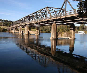
Bridge over the Karuah River
|
|||||||||||||||
| Population | 1,411 (2016 census) | ||||||||||||||
| • Density | 19.145/km2 (49.59/sq mi) | ||||||||||||||
| Postcode(s) | 2324 | ||||||||||||||
| Elevation | 16 m (52 ft) | ||||||||||||||
| Area | 73.7 km2 (28.5 sq mi) | ||||||||||||||
| Time zone | AEST (UTC+10) | ||||||||||||||
| • Summer (DST) | AEDT (UTC+11) | ||||||||||||||
| Location |
|
||||||||||||||
| LGA(s) |
|
||||||||||||||
| Region | Hunter, Mid North Coast | ||||||||||||||
| County | Gloucester | ||||||||||||||
| Parish | Tarean | ||||||||||||||
| State electorate(s) | Port Stephens | ||||||||||||||
| Federal Division(s) | Lyne | ||||||||||||||
|
|||||||||||||||
|
|||||||||||||||
Karuah (pronounced "ka-ROO-uh") is a small town in New South Wales, Australia. It's located where the Karuah River meets Port Stephens. The name "Karuah" is believed to come from an Aboriginal word meaning 'native plum tree'. This town is special because it's split between two different local government areas: Port Stephens Council and Mid-Coast Council.
Contents
Karuah's Past: A Journey Through Time
The story of Karuah began a long time ago. In 1790, five convicts escaped from Sydney and settled in this area. Later, in 1795, the Karuah River was explored and mapped.
In 1811, Governor Lachlan Macquarie decided to name the area "the Clyde". By 1816, people were given permission to cut cedar trees here. In 1824, a big company called the Australian Agricultural Company bought a huge piece of land to create a town. The name of the area was officially changed to Karuah in 1907.
Where is Karuah?
Karuah is unique because it sits across two different local government areas. Most of the town, about 51%, is in the Port Stephens Council area. The main village of Karuah is also mostly within Port Stephens Council.
The Karuah River flows through the middle of Karuah. This river actually forms the boundary between the two councils in this area. Karuah is located at the top-left corner of Port Stephens, which is where the Karuah River flows into the larger bay.
Who Lives in Karuah?
According to the 2016 census, there were 1,411 people living in Karuah.
- About 14.6% of the people were Aboriginal and Torres Strait Islander people.
- Most people, 80.1%, were born in Australia.
- Also, 89.8% of people spoke only English at home.
- When it came to religion, the most common choices were Anglican (26.7%), No Religion (25.0%), and Catholic (19.9%).
The main part of Karuah is the village itself. It's located on the old Pacific Highway and is split by the Karuah River. Most of the village is in the Port Stephens area. This village is home to the largest Aboriginal community in the Port Stephens area.
Getting Around Karuah
A very important bridge, the Karuah Bridge, was built and opened in December 1957. This bridge helped people cross the river easily.
Later, in 2004, the Karuah Bypass was opened. This new road helps cars and trucks travel faster past the town. While it made journeys quicker, it also meant less traffic went directly through the town.
Karuah's Famous Oysters
Karuah village has been well-known for its delicious oysters for a long time. You can still find several oyster shops along the old Pacific Highway in the town. They are a big part of Karuah's local identity!
 | Anna J. Cooper |
 | Mary McLeod Bethune |
 | Lillie Mae Bradford |


