
Kay Moor, West Virginia facts for kids
Quick facts for kids |
|
|
Kay Moor
|
|
 |
|

Location in West Virginia

Location in the United States
|
|
| Location | Fayette County, West Virginia |
|---|---|
| Nearest city | Fayetteville, West Virginia |
| Built | 1900 |
| Architect | Low Moor Iron Co.; New River & Pocahontas Consolidated |
| Architectural style | Mining structures |
| NRHP reference No. | 90001641 |
| Added to NRHP | November 8, 1990 |
Kay Moor, also known as Kaymoor, is an old, abandoned coal mine and town in West Virginia. It's located near Fayetteville, West Virginia, in a beautiful area called the New River Gorge. Imagine a town built just for coal miners and their families!
The main part of the town, called Kaymoor Bottom, was right by the New River. The actual mine entrance was much higher up, about 560 feet above the town. Big conveyor belts moved the coal down the steep gorge wall. This mine dug up a special type of coal called "smokeless" coal, which was great for fuel. The only way to get to the town was by train, using the Chesapeake and Ohio Railway. Even higher up, at the top of the gorge, was Kaymoor Top. This was where the coal was brought up from the mine before being sent down to the processing plant.
Contents
A Look Back: Kay Moor's History
Starting the Mine
The land where Kay Moor is located was bought in 1873 by a company called Low Moor Iron Company. They needed coal and a fuel called coke for their factories. But they didn't start mining right away. The Kay Moor mine finally opened in 1899.
In 1925, a new company, New River and Pocahontas Consolidated Coal Company, bought the mine. This company was a part of a bigger business from Philadelphia.
Building the Town
The town of Kay Moor was named after James Kay. He was an employee of the Low Moor Iron Company and was in charge of building the town. In 1901, about 50 houses were built for the miners and their families. More houses were added in the next few years.
Later, a small neighborhood called New Camp was built between 1918 and 1919. This is the only part of the original town that still exists today. The town didn't have many public buildings. There were no churches, banks, or a town hall. Instead, it had separate schools for different groups of children, company stores, a pool hall, and a ball field. By 1952, most people had left Kaymoor Bottom. In 1960, a fire destroyed many of the remaining buildings.
Moving Coal and People
Getting around Kay Moor was tricky because of the steep hills. Workers and equipment used a special single-track incline, like a steep railway, to go up and down. This track was 1,000 feet long and very steep.
Coal was moved using a similar double-track incline. This system lowered the coal to the processing plant and the coke ovens. The cars on this track would move in opposite directions, helping to balance each other. Both of these inclines were used until 1962.
When the mine first started, it had 120 ovens to make coke. During World War I, they added even more, bringing the total to 202 ovens. However, these ovens became old-fashioned and were all closed by the 1930s.
The mine itself was a room and pillar mine. This means miners dug out "rooms" and left "pillars" of coal to support the roof. At first, mules pulled the railcars full of coal. Later, locomotives (small trains) took over from the mules.
Kay Moor Today: What's Left?
Today, the Kay Moor site is mostly covered by plants and trees. Many of the old buildings and machines have rusted and fallen apart because of the coal dust and rain. Even so, there are still many pieces of mining equipment left. Kay Moor is considered one of the best examples of a complete coal mine and company town in West Virginia.
The entire Kay Moor area is now part of the New River Gorge National Park and Preserve. This means it's protected and you can visit it!
Visiting Kay Moor
You can get to Kaymoor Top by driving on Kaymoor No. 1 Road (County Route 9/2). From Kaymoor Top, you can find the Kaymoor Miners Trail. This trail has stairs and switchbacks that lead you directly to the Kaymoor Mine level. From there, you can continue down more stairs to Kaymoor Bottom.
Another way to reach the Kaymoor Mine level is by taking the Kaymoor Trail. This trail is about 2 miles long and fairly flat. You can find the trailhead for this path on County Route 82.
Images for kids
-
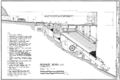
HAER drawing of Kay Moor headhouse

