Kentfield, California facts for kids
Quick facts for kids
Kentfield
|
|
|---|---|

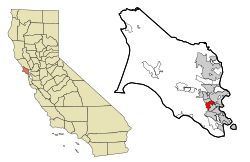
Location in Marin County and the state of California
|
|
| Country | |
| State | |
| County | Marin |
| Area | |
| • Total | 3.046 sq mi (7.89 km2) |
| • Land | 3.027 sq mi (7.84 km2) |
| • Water | 0.019 sq mi (0.05 km2) 0.62% |
| Elevation | 115 ft (35 m) |
| Population
(2020)
|
|
| • Total | 6,808 |
| • Density | 2,249.1/sq mi (868.4/km2) |
| Time zone | UTC−8 (PST) |
| • Summer (DST) | UTC−7 (PDT) |
| ZIP codes |
94904, 94914 (PO boxes)
|
| Area codes | 415/628 |
| FIPS code | 06-38114 |
| GNIS feature ID | 1658892 |
Kentfield is a small community in Marin County, California. It's located just north of San Francisco. Kentfield is considered a census-designated place (CDP), which means it's a special area defined by the government for counting people.
This community sits about 2 miles (3.2 km) southwest of downtown San Rafael. It's also 115 feet (35 meters) above sea level. In 2020, about 6,808 people lived here. Kentfield shares its ZIP codes (94904 and 94914) with the nearby town of Greenbrae.
Contents
History of Kentfield
Kentfield has had a few different names over the years, including Ross Landing, Tamalpais, and Kent.
Early Beginnings: Ross Landing
In 1857, a man named James Ross bought a large piece of land called Rancho Punta de Quentin. Ross, who came from Scotland, had made a lot of money in San Francisco. He set up a trading post here called "Ross Landing." Boats would travel up Corte Madera Creek to reach this landing.
The Kent Family's Influence
Later, in 1871, Albert Emmett Kent bought the land from the Ross family. Kent built a large home and named his estate Tamalpais. This name was later used for the nearby train station. Albert's son, William Kent, became a famous US Congressman and helped create Muir Woods National Monument.
Changing Names: From Kent to Kentfield
The train station's name was changed to Kent in the 1890s. Finally, in 1905, when the first post office opened, the community became known as Kentfield.
Geography of Kentfield
Kentfield is located on the eastern side of Mount Tamalpais. It is surrounded by other communities. To the north is Ross, to the northeast is San Rafael, and to the south is Larkspur.
The United States Census Bureau reports that Kentfield covers about 3.0 square miles (7.8 square kilometers). A very small part of this area, about 0.02 square miles (0.05 square kilometers), is water.
Climate in Kentfield
Kentfield has a mild climate, but it can get quite warm in the summer.
Temperature Trends
The warmest month is usually July, with average high temperatures around 82.7°F (28.2°C) and lows around 53.0°F (11.7°C). December is the coolest month, with highs averaging 54.8°F (12.7°C) and lows around 41.3°F (5.2°C).
The highest temperature ever recorded was 112°F (44°C) on July 11, 1913. The lowest was 17°F (-8°C) on December 31, 1915. On average, Kentfield sees about 19 days a year where the temperature reaches 90°F (32°C) or higher. Freezing temperatures (32°F or 0°C) happen about 4 days each year.
Rainfall and Snowfall
Kentfield receives a lot of rain compared to many other places in the San Francisco Bay Area. It normally gets about 48 inches (1,219 mm) of rain each year, spread over about 69 days. The most rain in one month was 26.95 inches (685 mm) in February 1986. The most rain in a single day was 11.56 inches (294 mm) on January 21, 1967.
While heavy snow can fall on nearby Mount Tamalpais, snow is very rare in Kentfield itself.
| Climate data for Kentfield, California, 1991–2020 normals, extremes 1902–present | |||||||||||||
|---|---|---|---|---|---|---|---|---|---|---|---|---|---|
| Month | Jan | Feb | Mar | Apr | May | Jun | Jul | Aug | Sep | Oct | Nov | Dec | Year |
| Record high °F (°C) | 79 (26) |
84 (29) |
91 (33) |
97 (36) |
102 (39) |
110 (43) |
112 (44) |
106 (41) |
110 (43) |
101 (38) |
89 (32) |
79 (26) |
112 (44) |
| Mean maximum °F (°C) | 66.3 (19.1) |
72.0 (22.2) |
77.6 (25.3) |
85.3 (29.6) |
90.3 (32.4) |
97.8 (36.6) |
97.5 (36.4) |
98.0 (36.7) |
97.3 (36.3) |
90.2 (32.3) |
75.8 (24.3) |
65.3 (18.5) |
102.2 (39.0) |
| Mean daily maximum °F (°C) | 56.6 (13.7) |
61.1 (16.2) |
65.1 (18.4) |
68.7 (20.4) |
73.5 (23.1) |
79.6 (26.4) |
82.5 (28.1) |
83.0 (28.3) |
82.1 (27.8) |
75.8 (24.3) |
63.6 (17.6) |
56.4 (13.6) |
70.7 (21.5) |
| Daily mean °F (°C) | 49.2 (9.6) |
52.2 (11.2) |
54.8 (12.7) |
57.5 (14.2) |
61.5 (16.4) |
65.8 (18.8) |
67.9 (19.9) |
68.3 (20.2) |
67.4 (19.7) |
62.9 (17.2) |
54.5 (12.5) |
49.1 (9.5) |
59.3 (15.2) |
| Mean daily minimum °F (°C) | 41.9 (5.5) |
43.2 (6.2) |
44.4 (6.9) |
46.3 (7.9) |
49.5 (9.7) |
52.0 (11.1) |
53.2 (11.8) |
53.6 (12.0) |
52.7 (11.5) |
50.0 (10.0) |
45.4 (7.4) |
41.7 (5.4) |
47.8 (8.8) |
| Mean minimum °F (°C) | 32.2 (0.1) |
33.8 (1.0) |
36.1 (2.3) |
38.5 (3.6) |
43.4 (6.3) |
46.5 (8.1) |
48.5 (9.2) |
48.7 (9.3) |
46.6 (8.1) |
41.9 (5.5) |
35.3 (1.8) |
31.7 (−0.2) |
29.9 (−1.2) |
| Record low °F (°C) | 18 (−8) |
21 (−6) |
24 (−4) |
29 (−2) |
33 (1) |
37 (3) |
37 (3) |
37 (3) |
34 (1) |
28 (−2) |
25 (−4) |
17 (−8) |
17 (−8) |
| Average precipitation inches (mm) | 8.77 (223) |
8.72 (221) |
6.00 (152) |
2.61 (66) |
1.40 (36) |
0.36 (9.1) |
0.00 (0.00) |
0.05 (1.3) |
0.09 (2.3) |
1.98 (50) |
4.63 (118) |
9.78 (248) |
44.39 (1,128) |
| Average precipitation days (≥ 0.01 in) | 11.5 | 11.0 | 10.6 | 6.2 | 3.7 | 1.1 | 0.2 | 0.2 | 0.9 | 3.7 | 7.5 | 11.6 | 68.2 |
| Source: NOAA | |||||||||||||
People of Kentfield: Demographics
The population of Kentfield has been counted in different years.
Population in 2010
In 2010, Kentfield had a population of 6,485 people. Most residents, about 91.1%, were White. About 3.5% were Asian, and 4.6% were of Hispanic or Latino background.
There were 2,572 households in Kentfield. About 34.7% of these households had children under 18 living there. The average household had about 2.51 people.
The population included 25.6% under 18 years old and 19.5% who were 65 or older. The average age was 47.0 years.
Population in 2000
In 2000, Kentfield had 6,351 people. The racial makeup was similar to 2010, with a majority of White residents.
The average income for a household in Kentfield was $117,457. For families, it was $154,673. The average income per person was $79,459. A small number of families and people lived below the poverty line.
Schools in Kentfield
Kentfield is home to several schools, from elementary to college level. Most of the area is part of the Kentfield Elementary School District.
Anthony G. Bacich Elementary School
A.G. Bacich Elementary School teaches students from kindergarten through 4th grade. It's recognized as a California Distinguished School. In the 2009–2010 school year, about 600 children attended. The school has a very high Academic Performance Index (API) score of 946 out of 1000, which means it's one of the top schools in California.
Adeline E. Kent Middle School
Adeline E. Kent Middle School serves students from 5th to 8th grade. It's also a California Distinguished School and a California Gold Ribbon School. In 2014, it had 522 students. Like Bacich, Kent Middle School has a high Academic Performance Index (API) of 944 out of 1000.
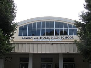
Marin Catholic High School
Marin Catholic High School is a private high school that prepares students for college. It is a Roman Catholic school and serves about 725 students. The school is owned by the Archdiocese of San Francisco.
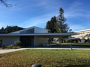
College of Marin
The main campus of the College of Marin is located in Kentfield, right across from Kent Middle School. This college is well-known for its theater program. It has a high rate of students who transfer to prestigious schools like Juilliard.
Notable People from Kentfield
Many interesting people have lived in or have connections to Kentfield:
- Frederic Lister Burk – An educator and university president.
- Jared Goff – A professional football quarterback for the Detroit Lions. He went to Marin Catholic High School.
- Charles S. Kilburn – A brigadier general in the U.S. Army.
- Brian McCall – A former outfielder for the Chicago White Sox baseball team.
- Gavin Newsom – The current governor of California and former mayor of San Francisco.
See also
 In Spanish: Kentfield para niños
 | Valerie Thomas |
 | Frederick McKinley Jones |
 | George Edward Alcorn Jr. |
 | Thomas Mensah |


