Keota, Iowa facts for kids
Quick facts for kids
Keota, Iowa
|
|
|---|---|
 |
|

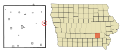
Location of Keota, Iowa
|
|
| Country | |
| State | |
| Counties | Keokuk, Washington |
| Townships | Lafayette, Seventy-Six |
| Area | |
| • Total | 0.77 sq mi (2.00 km2) |
| • Land | 0.77 sq mi (2.00 km2) |
| • Water | 0.00 sq mi (0.00 km2) |
| Elevation | 801 ft (244 m) |
| Population
(2020)
|
|
| • Total | 897 |
| • Density | 1,160.41/sq mi (447.84/km2) |
| Time zone | UTC-6 (Central (CST)) |
| • Summer (DST) | UTC-5 (CDT) |
| ZIP code |
52248
|
| Area code(s) | 641 |
| FIPS code | 19-40980 |
| GNIS feature ID | 2395518 |
Keota is a small city located in Iowa, United States. It's found in both Keokuk and Washington counties. In 2020, the city had a population of 897 people.
Contents
The History of Keota
The name "Keota" comes from an old Indian word. It means "gone to visit" or "the fire is gone out."
Major Events: The 2010 Fire
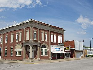
On December 4, 2010, a large fire caused a lot of damage in downtown Keota. Five buildings on East Broadway were badly hurt or completely destroyed.
Major Events: The 2023 Tornado
On March 31, 2023, a very strong EF4 tornado hit the northwest part of Keota. It caused a lot of damage to many farms just outside the city. After the tornado, many volunteers came to help clean up and recover.
Keota's Geography
Keota is located in the eastern part of Keokuk County. The city limits even reach into Washington County to include a golf course. Keota is about 15 miles (24 km) east of Sigourney, which is the county seat for Keokuk County. It's also about 17 miles (27 km) northwest of Washington.
The United States Census Bureau says that Keota covers a total area of about 0.63 square miles (1.63 square kilometers). All of this area is land.
Keota's Population and People
Keota has seen its population change over the years. Here's a look at how many people have lived in the city:
| Historical populations | ||
|---|---|---|
| Year | Pop. | ±% |
| 1880 | 710 | — |
| 1890 | 777 | +9.4% |
| 1900 | 996 | +28.2% |
| 1910 | 988 | −0.8% |
| 1920 | 1,025 | +3.7% |
| 1930 | 955 | −6.8% |
| 1940 | 1,032 | +8.1% |
| 1950 | 1,145 | +10.9% |
| 1960 | 1,096 | −4.3% |
| 1970 | 1,112 | +1.5% |
| 1980 | 1,034 | −7.0% |
| 1990 | 1,000 | −3.3% |
| 2000 | 1,025 | +2.5% |
| 2010 | 1,009 | −1.6% |
| 2020 | 897 | −11.1% |
| Source: and Iowa Data Center Source: |
||
Understanding the 2020 Census
According to the census in 2020, Keota had 897 people living there. There were 384 households and 239 families. The city had about 1,160 people per square mile (448 per km2).
Most of the people in Keota, about 94.9%, were White. A smaller number were Black or African American (0.9%), Native American (0.1%), or from two or more races (3.5%). About 3.2% of the population were Hispanic or Latino.
The average age in Keota was 42.4 years old. About 27.6% of the residents were under 20 years old. Also, 21.2% were 65 years old or older. The city had a nearly even number of males and females.
Understanding the 2010 Census
In 2010, the census showed that 1,009 people lived in Keota. There were 408 households. The population density was about 1,602 people per square mile (618 per km2).
The racial makeup of the city was mostly White (98.3%). A small number were African American (0.4%), Asian (0.2%), or from two or more races (1.1%). About 0.2% of the population was Hispanic or Latino.
The average age in Keota in 2010 was 40.5 years. About 26.4% of the people were under 18 years old. Also, 17.3% were 65 years old or older. The city had a nearly even number of males and females.
Education in Keota
Keota is home to the Keota Community School District. This district provides education for students from kindergarten all the way through 12th grade. The school's mascot is the Eagle, and their school colors are Purple and Gold.
See also
 In Spanish: Keota (Iowa) para niños
 | Charles R. Drew |
 | Benjamin Banneker |
 | Jane C. Wright |
 | Roger Arliner Young |

