Khagrachhari District facts for kids
Quick facts for kids
Khagrachari
খাগড়াছড়ি
|
|
|---|---|

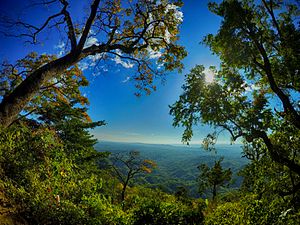
View of Konglak Hill, Khagrachari
|
|
| Nickname(s):
প্রাকৃতিক সৌন্দর্যের রাণী (The Queen of Natural Beauty) / উপত্যকার শহর (The City of Valleys)
|
|
| Motto(s):
বৈচিত্র্যে সৌন্দর্য (Beauty Lies in Diversity)
|
|

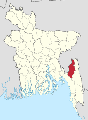
Location of Khagrachari District within Bangladesh
|
|
| Country | |
| Division | Chittagong Division |
| Area | |
| • Total | 2,749.16 km2 (1,061.46 sq mi) |
| Population
(2022 census)
|
|
| • Total | 714,119 |
| • Density | 259.7590/km2 (672.7727/sq mi) |
| Demonym(s) | Khagrasoria |
| Time zone | UTC+06:00 (BST) |
| Postal code |
4400
|
| HDI (2018) | 0.593 medium · 14th of 21 |
Khagrachari (Bengali: খাগড়াছড়ি) is a district in the Chittagong Division of Southeastern Bangladesh. It is part of the Chittagong Hill Tracts region. This area is known for its beautiful hills and diverse cultures.
Contents
History of Khagrachari
The Chittagong Hill Tracts region, where Khagrachari is located, was once ruled by different groups. These included the Tripura State, the Arakans, and various Sultans. In 1760, the British East India Company took control.
Even after the British took over, local kings or chiefs managed the area. In 1860, a new area called the Mun Circle was created in what is now Khagrachari. It was later renamed the Mong Circle.
In 1900, the British gave the Chittagong Hill Tracts special independent status. This was to respect the local people's culture and languages. However, this special status ended during the Partition of India. The area then became part of East Bengal, which was ruled by Pakistan.
Khagrachari was first a subdivision called Ramgarh. Its main office was in Khagrachari town. In 1983, it became a full district, which is called a "zila" in Bangladesh. The name Khagrachari likely comes from two local words. "Khagra" means a type of plant called Catkin, and "Chhara" means a stream. The district headquarters is on the bank of the Chengi stream, which used to have many Catkin plants.
To help local people manage their own affairs, the Khagrachari Local Government Council was set up in 1989. This council works to protect the rights and improve the lives of all residents. It was later renamed the Khagrachari Hill District Council (KHDC) in 1998, following a 'Peace Accord'. Today, this council is very important for the district's administration and development.
Geography of Khagrachari
Khagrachari is a hilly area. It shares borders with the Tripura state of India to the north and west. To the east, it borders the Rangamati district. The Chittagong District is to its southwest.
Some of the notable hill ranges in Khagrachari are Golamoon, Chotto Panchari, and Karmi Mura. The district has three main rivers: Chengi, Feni, and Maini. The Chengi River is the longest in Khagrachari.
Many different groups of people live here. The main ethnic groups include the Tripuris, Chakmas, Bengalis, and Marmas.
People and Population
Khagrachari District is home to many people. According to the 2022 census, about 714,119 people live here. A good number of them, about 41.7%, live in towns and cities. The district has a population density of 260 people per square kilometer. This means there are 260 people living in every square kilometer of land.
The literacy rate for people aged 7 and over is 71.7%. This means that almost three-quarters of the people can read and write.
Many different indigenous (native) communities live in Khagrachari. In 2011, there were over 316,000 indigenous people. These groups include the Tripuri, Rakhaine, Chakma, Marma, and Tanchangya people.
Religions in Khagrachari
Khagrachari is a place where people of different religions live together.
| Religions in Khagrachhari district (2022) | ||||
|---|---|---|---|---|
| Religion | Percent | |||
| Muslims | 46.56% | |||
| Buddhists | 35.92% | |||
| Hindus | 16.75% | |||
| Christians | 0.62% | |||
| Other or not stated | 0.16% | |||
Divisions of Khagrachari
Khagrachari District is divided into smaller areas called Upazilas. These are like sub-districts. There are 9 Upazilas in Khagrachari:
- Dighinala Upazila
- Khagrachhari Sadar Upazila
- Lakshmichhari Upazila
- Mahalchhari Upazila
- Manikchhari Upazila
- Matiranga Upazila
- Panchhari Upazila
- Ramgarh Upazila
- Guimara Upazila
The district also has 3 Paurashavas (municipalities), 38 Unions, and many villages.
Administration
The main leaders who manage Khagrachari are:
- Deputy Commissioner (DC): Protap Chandro Biswas
- Chairman of Hill District Council: Mr. Kongjari Chowdhury
Economy
Many people in Khagrachari make a living from farming. A common farming method here is called Jhum cultivation. This is a type of shifting cultivation often used in hilly areas.
Besides farming, people also work as teachers, business owners, and in other jobs. Tourism is becoming a very important way for people to earn money in the area. Many visitors come to see the natural beauty of Khagrachari.
The main sources of income for the people are:
- Agriculture: 59.92%
- Non-agricultural labor: 9.33%
- Commerce (buying and selling goods): 10.67%
- Services (like working in shops or offices): 7.94%
Education
Education is important in Khagrachari. About 83% of students attend school. The district has many educational institutions. These include 18 colleges, 71 high schools, and 13 madrasas (religious schools).
Some of the well-known schools and colleges are:
- Khagrachhari Government College (started in 1974)
- Matiranga Degree College (started in 1992)
- Ramgarh Government Degree College (started in 1980)
- Khagrachhari Government High School (started in 1957)
- Ramgarh Government High School (started in 1952)
Old Buildings and Sites
Khagrachari has some interesting old places. One is the Rajbari, which was the palace of the Mong Circle rulers. Another is the Dighi of Dighinala, a large pond dug by Gobinda Manikya Bahadur, a king from Tripura.
Transportation
In the past, people in Khagrachari used traditional ways to travel. These included palanquins (carried chairs), elephant carts, and bullock carts. They also used country boats on the rivers. Most of these old ways of transport are no longer used.
Today, all the Upazilas are connected to the district headquarters by paved roads. People travel by bus, minibus, and three-wheelers. A special type of jeep called "Chander Gari" is popular for traveling in the hilly areas.
Climate
Khagrachari has a warm climate. The average yearly temperature ranges from a high of 34.6°C to a low of 13°C. The area also gets a lot of rain, with an average of 3031 mm per year.
Members of Parliament
A Member of Parliament (MP) is a person elected by the people to represent them in the national parliament. For Khagrachhari, the current MP is Kujendra Lal Tripura from the Awami League party. Other MPs who have represented Khagrachhari in the past include Jotindra Lal Tripura and Wadud Bhuiyan.
Notable People
Many important people come from Khagrachari. Some of them are:
- Birendra Kishore Roaza
- Kujendra Lal Tripura
- Naba Bikram Kishore Tripura
- Jotindra Lal Tripura
- Basanti Chakma
- Wadud Bhuiyan
See also
 In Spanish: Khagrachari (zila) para niños
- Alutila Cave
- Matai Hakor
- Matai Pukhiri
- Tuari Mairang
- Mayung Kopal
- Palashpur
- Districts of Bangladesh
- Tripuri people
- Chakma people
- Marma people
 | Valerie Thomas |
 | Frederick McKinley Jones |
 | George Edward Alcorn Jr. |
 | Thomas Mensah |

