Kilchis River facts for kids
Quick facts for kids Kilchis River |
|
|---|---|

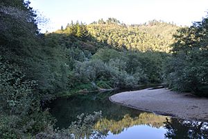
Lower Kilchis River near Idaville
|
|
|
Location of the mouth of the Kilchis River in Oregon
|
|
| Country | United States |
| State | Oregon |
| County | Tillamook County |
| Physical characteristics | |
| Main source | Northern Oregon Coast Range East of Tillamook 305 ft (93 m) 45°36′15″N 123°45′14″W / 45.60417°N 123.75389°W |
| River mouth | Tillamook Bay Oregon 13 ft (4.0 m) 45°29′46″N 123°51′53″W / 45.49611°N 123.86472°W |
| Length | 14 mi (23 km) |
| Basin features | |
| Basin size | 65 sq mi (170 km2) |
The Kilchis River is a stream about 14 miles (23 km) long. It is located near the coast of northwest Oregon in the United States. The river flows through a mountainous, forested area in the Northern Oregon Coast Range. Its entire basin covers about 65 square miles (170 km2).
The Kilchis River starts where its North Fork and South Fork join together. This is in northern Tillamook County, within the Tillamook State Forest. It flows southwest and empties into the southeast part of Tillamook Bay. This spot is about 4 miles (6.4 km) northwest of the city of Tillamook. The Kilchis River is one of five rivers that flow into Tillamook Bay. The others are the Tillamook, the Trask, the Wilson, and the Miami rivers.
Contents
River Journey: Where the Kilchis Flows
The Kilchis River begins where its two main branches, the North Fork and South Fork Kilchis River, meet. From there, it generally flows southwest. The river winds through the Tillamook State Forest, often running alongside Kilchis River Road.
Several smaller streams join the Kilchis River along its path.
- Sharp Creek flows in from the right side of the river. This happens about 9 miles (14 km) before the Kilchis reaches the bay.
- Just after Sharp Creek, School Creek and Washout Creek also enter from the right.
- The Little South Fork Kilchis River joins from the left side.
- Further downstream, Clear Creek adds its waters from the left.
- Finally, Myrtle Creek and Murphy Creek flow in from the right.
The river then passes under U.S. Route 101. Soon after, it flows into Tillamook Bay near a place called Idaville.
Fish and Fishing on the Kilchis River
The Kilchis River is a great place for fishing! It has good runs of two popular types of fish:
- Steelhead: These are a type of rainbow trout.
- Chinook salmon: These are large salmon that return to the river in the fall.
Much of the land along the lower part of the river is privately owned. Because of this, many people fish from special boats called drift boats. These boats can be launched from public boat ramps. You can find these ramps at Kilchis County Park, County Park, and Mapes Creek. If you prefer to fish from the land, there are also public areas along the river in the Tillamook State Forest.
Kilchis Point Reserve: History and Nature
The Tillamook County Pioneer Museum manages a special area called Kilchis Point Reserve. This reserve covers about 200 acres (81 ha) of land right along Tillamook Bay. It's a wonderful place to explore nature and learn about history.
The reserve has about 2 miles (3 km) of walking trails. Along these trails, you can learn about the area's past.
- Native American Heritage: This spot was once home to the largest Native American village on the North Oregon Coast.
- Pioneer History: It was also where Joe Champion, the first white settler, built his home in 1851.
The trails also teach you about the different plants and animals that live in the reserve. It's a great way to connect with both nature and the rich history of the region.
Who Was Chief Kilchis?
The Kilchis River was named after an important leader from the 19th century. This leader was Chief Kilchis, a member of the Tillamook people. His original Tillamook name was [gə́lšəs] or [gə́lčəs]. Naming the river after him honors his significance to the local Native American community.
 | May Edward Chinn |
 | Rebecca Cole |
 | Alexa Canady |
 | Dorothy Lavinia Brown |


