Trask River facts for kids
Quick facts for kids Trask River |
|
|---|---|

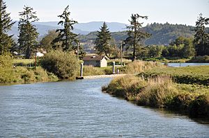
Trask River from Oregon Route 131 bridge at Tillamook
|
|
|
Location of the mouth of the Trask River in Oregon
|
|
| Country | United States |
| State | Oregon |
| County | Tillamook County |
| Physical characteristics | |
| Main source | Northern Oregon Coast Range Tillamook State Forest, East of Tillamook 281 ft (86 m) 45°26′23″N 123°36′41″W / 45.43972°N 123.61139°W |
| River mouth | Tillamook Bay Oregon 3 ft (0.91 m) 45°28′13″N 123°52′57″W / 45.470381°N 123.882627°W |
| Length | 18 mi (29 km) |
| Basin features | |
| Basin size | 175 sq mi (450 km2) |
The Trask River is a river in northwestern Oregon in the United States. It flows through a hilly, forested area of the Northern Oregon Coast Range. The river empties into Tillamook Bay and then into the Pacific Ocean.
The Trask River is one of five main rivers that flow into Tillamook Bay. The others are the Tillamook, the Wilson, the Kilchis, and the Miami.
The main part of the Trask River is about 18 miles (29 km) long. It starts where its two main branches, called forks, meet. The North Fork is about 30 miles (48 km) long. It begins in the Tillamook State Forest in western Washington County. The South Fork is about 10 miles (16 km) long and starts in southern Tillamook County.
The Trask River is famous for its fish, especially Steelhead and Chinook salmon. Many people enjoy fishing here.
The river is named after Elbridge Trask, who settled near Tillamook Bay in 1848. His journey was written about in a historical novel called Trask by Don Berry.
River's Journey
The Trask River begins when its two main branches, the North Fork Trask River and the South Fork Trask River, join together. This meeting point is near Trask County Park in the Tillamook State Forest.
For much of its path, the Trask River flows next to Trask River Road. It generally flows towards the west. Along its way, many smaller streams flow into it. For example, Rowe Creek joins from the left side, and Samson Creek joins from the right. Other creeks like Burton, Blue Ridge, and Panther creeks also add water to the river.
The river passes a special measuring station that checks its flow. This station is about 10.95 miles (17.62 km) from where the river meets the bay. After this point, more creeks like Gold, Hanenkrat, and Green creeks join the Trask River.
About 5 miles (8.0 km) from its end, Mill Creek flows into the Trask River. Then, about 1 mile (1.6 km) later, the river goes under U.S. Route 101. It flows around the edge of the town of Tillamook. Finally, the Trask River joins the Tillamook River and flows into Tillamook Bay.
River Flow
The United States Geological Survey (USGS) keeps track of how much water flows in the Trask River. They have a measuring station about 10.95 miles (17.62 km) from the river's mouth.
From 1996 to 2008, the river's average flow at this station was about 985 cubic feet per second (27.9 m3/s). This measurement comes from an area of about 156 square miles (404 km2). This area makes up about 89 percent of the entire Trask River watershed, which is the land area that drains water into the river.
The most water ever recorded flowing through this spot was 22,500 cubic feet per second (640 m3/s) on November 25, 1999. The least amount of water recorded was 49 cubic feet per second (1.4 m3/s) on September 11, 2007.
 | Delilah Pierce |
 | Gordon Parks |
 | Augusta Savage |
 | Charles Ethan Porter |


