Wilson River (Oregon) facts for kids
Quick facts for kids Wilson River |
|
|---|---|

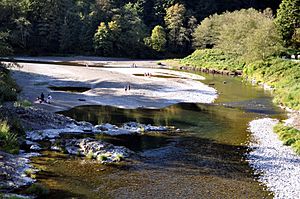
Wilson River from Oregon Route 6 bridge near Tillamook
|
|
|
Location of the mouth of the Wilson River in Oregon
|
|
| Country | United States |
| State | Oregon |
| County | Tillamook County |
| Physical characteristics | |
| Main source | Northern Oregon Coast Range East of Tillamook 871 ft (265 m) 45°36′22″N 123°27′45″W / 45.60611°N 123.46250°W |
| River mouth | Tillamook Bay Oregon 0 ft (0 m) 45°28′44″N 123°53′24″W / 45.47889°N 123.89000°W |
| Length | 33 mi (53 km) |
| Basin features | |
| Basin size | 194 sq mi (500 km2) |
The Wilson River is a beautiful river in Oregon, a state in the United States. It's about 33 miles (53 kilometers) long. This river starts in the Northern Oregon Coast Range mountains and flows all the way to Tillamook Bay. It's one of five important rivers that empty into Tillamook Bay. The other rivers are the Tillamook, the Trask, the Kilchis, and the Miami.
Contents
River's Journey
The Wilson River begins its journey in the Tillamook State Forest. This forest is located in the mountains of northeastern Tillamook County. The river is formed when several smaller streams, called forks, join together.
How the River Forms
The river has a North Fork and a South Fork. The North Fork starts in northern Tillamook County and flows south. The South Fork begins in eastern Tillamook County and western Washington County. It flows west and meets another stream called Devils Lake Fork.
Further downstream, the main Wilson River receives water from the North Fork near Lees Camp. From there, it flows southwest towards the city of Tillamook. Finally, it enters the southeast part of Tillamook Bay. This is about 3 miles (5 kilometers) northwest of the city.
River's Location
The mouth of the Wilson River is about 1 mile (1.6 kilometers) north of the Trask River's mouth. It's also slightly south of where the Kilchis River enters the bay. A road called Oregon Route 6, also known as the Wilson River Highway, runs next to the river. This highway connects the Tualatin Valley and the Portland area with the Oregon Coast.
Water Flow
The United States Geological Survey (USGS) keeps track of how much water flows in the Wilson River. They have a special measuring station about 9.3 miles (15 kilometers) from where the river meets the bay. On average, about 1,177 cubic feet (33.3 cubic meters) of water flow past this station every second. This measurement covers about 83 percent of the entire Wilson River area.
The most water ever recorded flowing there was 38,600 cubic feet (1,093 cubic meters) per second. This happened on November 6, 2006. The least amount of water recorded was 32 cubic feet (0.91 cubic meters) per second on September 5, 1973.
Fishing Fun
The Wilson River is a very popular spot for fishing. Many people consider it one of the best places in Oregon to catch certain types of fish.
Types of Fish
The river is famous for its steelhead and Chinook salmon. Steelhead are a type of rainbow trout. Spring Chinook salmon usually weigh around 20 pounds (9.1 kilograms). Fall Chinook salmon are even bigger, often weighing between 25 to 28 pounds (11 to 13 kilograms). Steelhead typically weigh about 10 to 12 pounds (4.5 to 5.4 kilograms).
Access for Anglers
It's easy for anglers (people who fish) to get to the river. There are boat launches owned by the county in the lower parts of the river. Also, Oregon Route 6 goes right through the Tillamook State Forest, giving public access to many spots along the river. The state has rules about when and how you can fish, so anglers need to follow those regulations.
 | James B. Knighten |
 | Azellia White |
 | Willa Brown |


