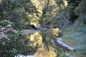
Miami River (Oregon) facts for kids
Quick facts for kids Miami River |
|
|---|---|

Lower Miami River
|
|
|
Location of the mouth of the Miami River in Oregon
|
|
| Country | United States |
| State | Oregon |
| County | Tillamook County |
| Physical characteristics | |
| Main source | Northern Oregon Coast Range Northeast of Tillamook 1,782 ft (543 m) 45°38′51″N 123°43′44″W / 45.64750°N 123.72889°W |
| River mouth | Tillamook Bay Oregon 7 ft (2.1 m) 45°33′35″N 123°53′37″W / 45.55972°N 123.89361°W |
| Length | 13 mi (21 km) |
| Basin features | |
| Basin size | 36.7 sq mi (95 km2) |
The Miami River is a stream located in the northwest part of Oregon, a state in the United States. It is about 13 miles (21 km) long. This river flows through a hilly, forested area of the Northern Oregon Coast Range. It eventually empties into the Pacific Ocean.
The river starts in northern Tillamook County, within the Tillamook State Forest. It generally flows towards the southwest. The Miami River then joins the northern part of Tillamook Bay, close to the town of Garibaldi. The river drops quickly from a high point of 1,782 feet (543 m) down to almost sea level. No towns are directly on its banks. The Miami River is one of five rivers that flow into Tillamook Bay. The others are the Tillamook, the Trask, the Wilson, and the Kilchis.
What's in a Name?
The name of the Miami River comes from an old Native American language called Chinook Jargon. The original phrase was Mi-me Chuck. This phrase meant a smaller river that flows into a bigger one, or a stream that is "downriver." Over time, people changed the name to "Miami." This is the same name used for places in Ohio and Florida.
The River's Journey
As the Miami River flows generally southwest through the forest, it meets several smaller streams.
- About 5.5 miles (8.9 km) from where it ends, Prouty Creek joins the river from the right side.
- Further downstream, Peterson Creek and Minich Creek also flow in from the right.
- Moss Creek enters from the left side, a little over 1 mile (1.6 km) before the river reaches the bay.
- Illingsworth Creek joins from the left.
- Struby Creek and Hobson Creek come in from the right.
- Soon after, the river goes under U.S. Route 101.
- Electric Creek then enters from the left as the river flows into Miami Cove, which is part of Tillamook Bay.
- The town of Garibaldi is located to the right of the river at this point.
- Miami Road runs alongside the lower parts of the river.
 | Georgia Louise Harris Brown |
 | Julian Abele |
 | Norma Merrick Sklarek |
 | William Sidney Pittman |


