Kimball Island facts for kids

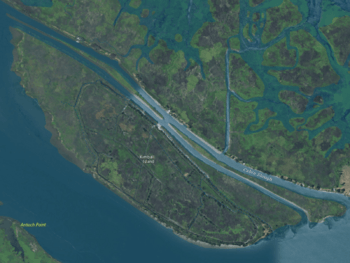
USGS aerial imagery of Kimball Island; Antioch is across the San Joaquin River to the south, and Sherman Island is across Cabin Slough to the north.
|
|
| Geography | |
|---|---|
| Location | Northern California |
| Coordinates | 38°01′38″N 121°49′00″W / 38.02722°N 121.81667°W |
| Adjacent bodies of water | Sacramento–San Joaquin River Delta |
| Highest elevation | 0 ft (0 m) |
| Administration | |
|
United States
|
|
| State | |
| County | Sacramento |
Kimball Island is a small piece of land located in the Sacramento–San Joaquin River Delta in California. It is also sometimes called Hammond Island. This island is part of Sacramento County. In 1981, experts measured its height as 0 feet (0 meters) above sea level.
Contents
Discover Kimball Island: A Delta Gem
Kimball Island is a fascinating spot within California's large delta region. It might be small, but it plays a part in the unique environment of the delta. Understanding islands like Kimball helps us learn about geography and history.
Where is Kimball Island Located?
Kimball Island is found in the heart of the Sacramento–San Joaquin River Delta. This delta is a special area where the Sacramento and San Joaquin rivers meet. They flow into the San Francisco Bay. The delta is a mix of waterways, islands, and marshlands.
The island's exact spot is at coordinates 38°01′38″N 121°49′00″W. It sits near the city of Antioch. To the north, across a channel called Cabin Slough, is Sherman Island.
A Look Back: Kimball Island's Past
Islands often have interesting histories, even small ones. Kimball Island has been known by different names over time. This shows how places can change names as maps and surveys are updated.
Early Maps and Names
One of the earliest maps showing this island dates back to 1850. This map was a survey of the San Francisco Bay Area. On this old map, the island was labeled "Hammond Island."
The survey was made by Cadwalader Ringgold. He was an important American naval officer and explorer. His work helped map out many parts of California. This early naming gives us a glimpse into the island's history.
 | Frances Mary Albrier |
 | Whitney Young |
 | Muhammad Ali |


