Knapp Creek, Queensland facts for kids
Quick facts for kids Knapp CreekQueensland |
|||||||||||||||
|---|---|---|---|---|---|---|---|---|---|---|---|---|---|---|---|

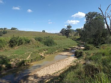
Landscape along Knapp Creek Road, 2016
|
|||||||||||||||
| Population | 59 (2021 census) | ||||||||||||||
| • Density | 0.697/km2 (1.81/sq mi) | ||||||||||||||
| Postcode(s) | 4285 | ||||||||||||||
| Area | 84.7 km2 (32.7 sq mi) | ||||||||||||||
| Time zone | AEST (UTC+10:00) | ||||||||||||||
| LGA(s) | Scenic Rim Region | ||||||||||||||
| State electorate(s) | Scenic Rim | ||||||||||||||
| Federal Division(s) | Wright | ||||||||||||||
|
|||||||||||||||
Knapp Creek is a small, quiet area in the countryside of Queensland, Australia. It's part of the Scenic Rim Region. In 2021, only 59 people lived here, making it a very small community.
Contents
What is Knapp Creek Like?
Knapp Creek gets its name from a stream called Knapps Creek. This stream flows into the larger Logan River.
Mountains in the Area
This area also has two mountains. Knapps Peak, also known as Miggun or Mount Hughes, is 651 meters (about 2,136 feet) tall. It's located in the southwest part of Knapp Creek.
Prouts Hill is another mountain, found in the southeast. It stands 459 meters (about 1,506 feet) high.
A Look at Knapp Creek's Past
Knapps Creek Provisional School first opened around 1884. It later became Knapps Creek State School in 1909. However, the school closed its doors in 1910.
In 1979, a special natural area called Knapp Creek Environmental Park was created. This park helps protect the local environment.
Who Lives in Knapp Creek?
According to the 2021 census, 59 people live in Knapp Creek. The area has 29 households.
In 2016, the population was also 59 people. At that time, about 41.8% of the people were males and 58.2% were females. The average age of people living here was 49 years old.
 | Claudette Colvin |
 | Myrlie Evers-Williams |
 | Alberta Odell Jones |


