Maroon, Queensland facts for kids
Quick facts for kids MaroonQueensland |
|||||||||||||||
|---|---|---|---|---|---|---|---|---|---|---|---|---|---|---|---|

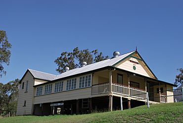
School of Arts, built 1904
|
|||||||||||||||
| Population | 152 (2021 census) | ||||||||||||||
| • Density | 1.307/km2 (3.39/sq mi) | ||||||||||||||
| Postcode(s) | 4310 | ||||||||||||||
| Area | 116.3 km2 (44.9 sq mi) | ||||||||||||||
| Time zone | AEST (UTC+10:00) | ||||||||||||||
| Location |
|
||||||||||||||
| LGA(s) | Scenic Rim Region | ||||||||||||||
| State electorate(s) | Scenic Rim | ||||||||||||||
| Federal Division(s) | Wright | ||||||||||||||
|
|||||||||||||||
Maroon is a small country area in the Scenic Rim Region of Queensland, Australia. In 2021, about 152 people lived there. It's a quiet place with a rich history and beautiful natural surroundings.
Contents
Maroon's Location and Mountains
Maroon is a rural area with some interesting natural features. Part of the Dugandan Range forms a small border in the northwest.
The area also has two mountains:
- Mount May, which is about 836 meters (2,743 feet) tall.
- Paddys Peak, which is about 546 meters (1,791 feet) tall.
The southern and eastern parts of Maroon, including these mountains, are protected. They are part of the Mount Barney National Park, which helps keep the natural environment safe.
A Look Back at Maroon's History
How Maroon Got its Name
The name 'Maroon' comes from an old Aboriginal word, wahlmoorum. This word is from the Yaggera language. It's linked to Mount Ballow and a story about a giant sand goanna.
Early Days and the School
The first big farm, called Maroon pastoral property, started in 1843. A cemetery in Maroon has graves from as far back as 1856.
Maroon Provisional School first opened its doors on July 15, 1891. It became Maroon State School on January 1, 1909. A new school building was officially opened on March 11, 1938.
Churches in Maroon
On November 17, 1907, St Andrew's Anglican Church was officially opened. It could seat 120 people. The land for the church was given by J. J. Prout. The church was closed in 2019 and is now used as a bed-and-breakfast.
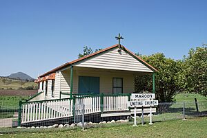
In July 1913, land was given to build a Methodist church. This church opened on December 7, 1913. It was 18 by 24 feet (about 5.5 by 7.3 meters) and had six Gothic windows. In 1977, this church became the Maroon Uniting Church. The original building was replaced around 1999. The church building was later sold and taken down by October 2014.
Farming and Community
In 1914, the large Maroon pastoral property was divided into 30 smaller dairy farms.
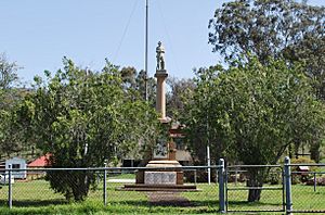
The Maroon War Memorial remembers those from the area who fought in World War I. It was officially opened on May 21, 1920.
Maroon Post Office opened on July 1, 1927, and closed in 1973.
The Maroon Dam was built in the west of Maroon between 1969 and 1974.
Who Lives in Maroon?
In 2021, Maroon had a population of 152 people. The average age of people living there was 46 years old.
Most people in Maroon were born in Australia (86.5%). The most common language spoken at home was English (93.9%). The most common family backgrounds were English, Australian, and German.
Historic Places in Maroon
Maroon has several places that are listed as important heritage sites. This means they are protected because of their history. These include:
- Maroon War Memorial, on Boonah-Rathdowney Road.
- Maroon State School, at 2772 Boonah Rathdowney Road.
- Maroon School of Arts, at the corner of Boonah Rathdowney Road and Newlove Road.
- St Andrew's Anglican Church, on Newlove Road.
- Cotswold Cottage, at 186 Cotswold Road.
Learning in Maroon
Maroon State School is a government primary school for students from Prep to Year 6. It is located at 2772 Boonah-Rathdowney Road. In 2023, the school had 21 students.
Maroon Outdoor Education Centre is a special center for outdoor and environmental education. It is located at 123 Maroon Dam Road.
There are no high schools in Maroon itself. The closest government high school is Boonah State High School in Boonah.
 | DeHart Hubbard |
 | Wilma Rudolph |
 | Jesse Owens |
 | Jackie Joyner-Kersee |
 | Major Taylor |


