
Kootenay Pass facts for kids
Quick facts for kids Kootenay Pass |
|
|---|---|
| Elevation | 1,775 m (5,823 ft) |
| Traversed by | |
| Location | British Columbia, Canada |
| Range | Selkirk Mountains |
| Coordinates | 49°3′29″N 117°2′31″W / 49.05806°N 117.04194°W |

Kootenay Pass, also called "the Salmo–Creston" by local people, is a high mountain pass in the Selkirk Mountains of British Columbia, Canada. It's a special place where the land slopes down in different directions. On one side, water flows towards the Pend Oreille River. On the other side, it flows towards the Kootenay River and Kootenay Lake.
This pass is an important route for the Crowsnest Highway. It helps connect the towns of Salmo and Creston across the Selkirk Mountains. When the highway first opened, it was even called the Kootenay Skyway.
The highest point of the pass is inside Stagleap Provincial Park, close to Bridal Lake. You can even see what the pass looks like right now! There's a special camera that shows live pictures all year long.
Kootenay Pass is one of the highest roads in Canada that stays open all year. However, it sometimes closes when the weather is bad. This happens for safety reasons, like controlling avalanches or clearing snow and debris. Other passes like Bow Summit in Banff National Park (2088 meters high) and Highwood Pass in Kananaskis Country (2206 meters high) are taller. But Highwood Pass closes for part of the year, from December to June.
Staying Safe: Avalanche Control
Keeping people safe at Kootenay Pass is very important, especially because of avalanches. An avalanche is when a lot of snow slides down a mountain very quickly. To prevent this, experts use a special system called Gazex. This system lets them start small, controlled avalanches from their office at the top of the pass. This way, they can clear the snow safely before it becomes a danger to drivers.
In the past, they used big cannons to fire shells into the snow to trigger avalanches. But sometimes, these shells didn't explode. Finding and removing these unexploded shells was dangerous and expensive. The Gazex system is much safer and easier to use.
Other Ways to Travel
Sometimes, Kootenay Pass has to close. When this happens, people traveling from the east side (like from Creston) need to take a different route. They have to drive north from Creston to catch the Kootenay Lake Ferry at Kootenay Bay. Then, they take the ferry across the lake and drive through Nelson to Castlegar to get back on Highway 3A.
When the pass is closed, many people use the ferry, so you might have to wait a long time. Usually, the ferry runs from early morning until late at night. But if Kootenay Pass is closed, the Kootenay Lake Ferry runs 24 hours a day until the pass reopens. This helps everyone get where they need to go safely.
Images for kids
-
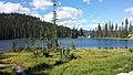
Bridal Lake at Kootenay Pass

