Kugluk/Bloody Falls Territorial Park facts for kids
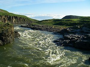
Kugluk/Bloody Falls Territorial Park is a special place in Nunavut, Canada. It's about 15 kilometers southwest of Kugluktuk. The park covers 10 hectares and is famous for the Bloody Falls on the Coppermine River. This area became a national historic site in 1978. The name 'kugluk' means 'waterfall' in Inuinnaqtun.
The park is also known for a sad event from the past. In 1771, an explorer named Samuel Hearne was traveling with some Chipewyan guides. They met a group of Copper Inuit at the falls. A conflict happened, which is now known as the Bloody Falls Massacre.
Contents
People of the Past and Present
This area has been important to different groups of people for thousands of years. Both Inuit and First Nations people used the land. Even though the Bathurst caribou herd doesn't usually come here now, this park was once a major hunting ground for them. People built huts from caribou antlers, showing how much they relied on these animals. The river and falls were also great for fishing, and they still are today.
Ancient Campsites
Scientists have found very old campsites in the park. Some pre-historic ancestors of the Dene people, from about 1500 years ago, camped here. There is also proof of even older Indian campsites, dating back 7000 years.
The Early Paleo-Eskimo people, part of the Pre-Dorset culture, lived here over 3500 years ago. More recently, about 500 years ago, the Thule people built stone houses in the park.
How People Use the Park Today
Since Nunavut became its own territory in 1999, the Dene people use this area less often. However, Inuit from Kugluktuk still visit to fish and hunt. The park is also a popular spot for tourists.
You can reach the park in a few ways:
- By motorboat: about 45 minutes.
- By all-terrain vehicle: about two hours.
- By walking: a four to five hour hike.
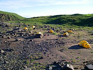
The park is a great place for canoeists traveling along the river. There's a special portage trail to help them get around the falls. The campsite is called "Onoagahiovik" in Inuinnaqtun. There are plans to build an information booth, and a "comfort station" (a washroom) is already there.
Park Geography
The park's landscape is typical Arctic tundra. Along the river, you'll see tall cliffs that lead to the falls. There are also rocky escarpments, which are steep slopes or cliffs. From some hills in the park, you can even see the Arctic Ocean! The Coppermine River is usually wide, but in the park, it squeezes through the cliffs. This creates the powerful falls before the river spreads out again.
Animals of the Park
When you visit the park, you might see many interesting animals. Large herds of caribou often pass through. You could also spot grizzly bears and wolverines.
Many different birds live here too:
Swallows are especially common. They build their nests in the cliffs around the falls.
Plants of the Park
The park is north of the tree line, which means it's too cold for most tall trees to grow. However, you can find some small, stunted trees like the dwarf willow along the Coppermine River.
Another plant found here is the black-tipped groundsel (Senecio lugens). This plant was named by John Richardson in 1821. He was traveling with John Franklin on an expedition. The word "lugens" comes from a Latin word meaning "to mourn." It was chosen to remember the sad event of the massacre.
 | Percy Lavon Julian |
 | Katherine Johnson |
 | George Washington Carver |
 | Annie Easley |


