
L'Anse, Michigan facts for kids
Quick facts for kids
L'Anse, Michigan
|
|
|---|---|
|
Village
|
|

Downtown L'Anse at River and Main Street
|
|
,_MI_location.png)
Location within Baraga County
|
|

L'Anse, Michigan
Location in Michigan

L'Anse, Michigan
Location in the United States
|
|
| Country | |
| State | |
| County | Baraga |
| Township | L'Anse |
| Area | |
| • Total | 2.55 sq mi (6.60 km2) |
| • Land | 2.55 sq mi (6.59 km2) |
| • Water | 0.00 sq mi (0.00 km2) |
| Elevation | 620 ft (189 m) |
| Population
(2020)
|
|
| • Total | 1,874 |
| • Density | 736.06/sq mi (284.16/km2) |
| Time zone | UTC-5 (Eastern (CST)) |
| • Summer (DST) | UTC-4 (EST) |
| ZIP code |
49946
|
| Area code(s) | 906 |
| FIPS code | 26-45540 |
| GNIS feature ID | 629897 |
L'Anse (say 'LAHNSS') is a small town in Michigan. It is the main town, or county seat, of Baraga County. In 2020, about 1,874 people lived there.
L'Anse is located in Michigan's Upper Peninsula, right on a beautiful bay. Part of the village is also within the L'Anse Indian Reservation.
Contents
History of L'Anse
The area where L'Anse is located was first home to the Ojibwa people, also known as Chippewa. They called this place "Gichi-wiikwedong."
Later, French explorers and traders set up a fur trading post and a Jesuit mission here. They named it L'Anse. In French, 'L'Anse' means 'the cove' or 'the bay.' This name fits perfectly because the village is right on L'Anse Bay, which is part of the bigger Keweenaw Bay. The town we see today grew from that early French trading post.
In the 1800s, after signing agreements with the United States, the Ojibwa people gave up a lot of their land. The L'Anse Indian Reservation was then created here by the U.S. government. It is the largest and oldest reservation in Michigan.
In 1896, a big fire sadly burned the entire village to the ground. Many people lost their homes.
Geography and Attractions
L'Anse is a small village, covering about 2.53 square miles (6.55 square kilometers). All of this area is land.
Fun Places to Visit
- The L'Anse Waterfront Park is a lovely spot right in the downtown area. It's a great place to relax and enjoy the views of the water.
- The Falls River Falls are in downtown L'Anse. These are a long series of waterfalls that stretch across the whole Falls River.
People of L'Anse
| Historical population | |||
|---|---|---|---|
| Census | Pop. | %± | |
| 1880 | 1,014 | — | |
| 1890 | 655 | −35.4% | |
| 1900 | 620 | −5.3% | |
| 1910 | 708 | 14.2% | |
| 1920 | 1,013 | 43.1% | |
| 1930 | 2,421 | 139.0% | |
| 1940 | 2,564 | 5.9% | |
| 1950 | 2,376 | −7.3% | |
| 1960 | 2,397 | 0.9% | |
| 1970 | 2,538 | 5.9% | |
| 1980 | 2,500 | −1.5% | |
| 1990 | 2,151 | −14.0% | |
| 2000 | 2,107 | −2.0% | |
| 2010 | 2,011 | −4.6% | |
| 2020 | 1,874 | −6.8% | |
| U.S. Decennial Census | |||
Population in 2020
According to the census from 2020, 1,874 people lived in L'Anse. The village had about 736 people per square mile. Most residents were White (85.6%), and 5.8% were Native American. About 7.5% of the population identified as being from two or more races.
Getting Around L'Anse
- US 41 is a main road that goes through the southern part of the village.
- M-38 is another state highway that starts in the nearby village of Baraga, which is across the bay from L'Anse.
- The Indian Trails bus company offers daily bus service. You can travel between Hancock, Michigan, and Milwaukee, Wisconsin, with a stop right in L'Anse.
Images for kids
-
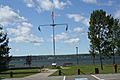
The L'Anse Waterfront Park is in the village on the shore of Lake Superior
-
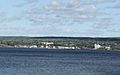
A view across the Keweenaw Bay to L'Anse.
-
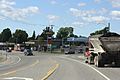
the L'Anse Intersection on US 41
-
The sign for L'Anse on US 41
-
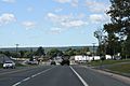
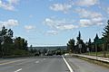
Going through L'Anse
-
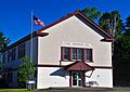
The L'Anse Township Hall
-
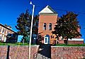
The Baraga County Courthouse and Annex is located in L'Anse.
-
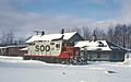
A train of the now-defunct Soo Line Railroad at L'Anse in 1967.


.jpg)
See also
 In Spanish: L'Anse (Míchigan) para niños
