LaFollette, Tennessee facts for kids
Quick facts for kids
LaFollette, Tennessee
|
|
|---|---|

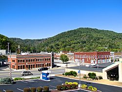
Buildings along Central Avenue (U.S. Route 25W)
|
|

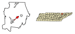
Location of LaFollette in Campbell County, Tennessee.
|
|
| Country | United States |
| State | Tennessee |
| County | Campbell |
| Area | |
| • Total | 4.91 sq mi (12.73 km2) |
| • Land | 4.91 sq mi (12.73 km2) |
| • Water | 0.00 sq mi (0.00 km2) |
| Elevation | 1,073 ft (327 m) |
| Population
(2020)
|
|
| • Total | 7,430 |
| • Density | 1,512.01/sq mi (583.74/km2) |
| Time zone | UTC-5 (Eastern (EST)) |
| • Summer (DST) | UTC-4 (EDT) |
| ZIP code |
37766
|
| Area code(s) | 423 |
| FIPS code | 47-40180 |
| GNIS feature ID | 1652480 |
LaFollette is a city located in Campbell County, Tennessee, in the United States. In 2020, about 7,430 people lived there. LaFollette is the main city in a smaller urban area that includes all of Campbell County. It is also part of the larger Knoxville Metropolitan Area.
The city's official name is spelled as one word: "LaFollette." It was named after its founders, Harvey Marion LaFollette and his younger brother Grant LaFollette. However, some government groups spell the city's name with two words: "La Follette."
Contents
History of LaFollette
Around 1890, brothers Harvey and Grant LaFollette bought a large area of land, about 37,000 acres (150 km2), at a place called Big Creek Gap. This is where the city is today. They started a company called the LaFollette Coal, Iron, and Railway Company. Their goal was to use the natural resources like coal and iron they found there.
Even though their business closed down in the 1920s, the community kept growing. LaFollette officially became a city in 1897. On May 10, 1904, a big fire started in a building called the Cumberland Inn. This fire burned down most of the downtown area. Reports say that 31 businesses were destroyed.
Geography and Location
LaFollette is located near the middle of Campbell County. It sits in Powell Valley, where the Appalachian mountains and valleys meet the Cumberland Plateau region.
North of LaFollette, you can see Cumberland Mountain. This mountain ridge stretches for about 50 mi (80 km). To the south, Norris Lake is a major feature of the area. The town of Jacksboro is right next to LaFollette, to the southwest.
A part of the Cumberland Trail can be reached from Tennessee Avenue at the north end of LaFollette. This trail is great for hiking and exploring nature.
The city covers an area of about 4.9 sq mi (12.7 km2), and it's all land. The height above sea level changes around the city. It's about 1,050 ft (320 m) in the valley areas and up to 1,500 ft (460 m) on the tops of the ridges. The average height is around 1,150 ft (350 m).
Major roads like U.S. Route 25W and State Routes 9 and 63 all go through the city. Interstate 75 is about 8 mi (13 km) to the southwest, past Jacksboro. The city of Jellico is about 23 mi (37 km) to the north if you take US 25W over the Cumberland Plateau.
About the People
2020 Census Information
The 2020 United States census counted how many people lived in LaFollette and learned more about them.
| Race | Number | Percentage |
|---|---|---|
| White (non-Hispanic) | 6,898 | 92.84% |
| Black or African American (non-Hispanic) | 37 | 0.5% |
| Native American | 14 | 0.19% |
| Asian | 24 | 0.32% |
| Other/Mixed | 299 | 4.02% |
| Hispanic or Latino | 158 | 2.13% |
In 2020, there were 7,430 people living in LaFollette. These people lived in 2,797 households, and 1,821 of these were families.
Notable People from LaFollette
Many interesting people have connections to LaFollette, including:
- Adele Arakawa – A well-known television news anchor.
- Howard "Louie Bluie" Armstrong – A talented musician.
- Haskel Ayers – A businessman and politician.
- The Isaacs – A family singing group famous for Southern gospel and bluegrass music.
- Carl Stiner – A general in the U.S. Army.
- J. Will Taylor – A congressman.
See also
 In Spanish: La Follette (Tennessee) para niños
 | Shirley Ann Jackson |
 | Garett Morgan |
 | J. Ernest Wilkins Jr. |
 | Elijah McCoy |

