La Paz, Indiana facts for kids
Quick facts for kids
LaPaz, Indiana
|
|
|---|---|
 |
|

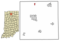
Location in Marshall County, Indiana
|
|
| Country | United States |
| State | Indiana |
| County | Marshall |
| Township | North |
| Area | |
| • Total | 0.39 sq mi (1.00 km2) |
| • Land | 0.39 sq mi (1.00 km2) |
| • Water | 0.00 sq mi (0.00 km2) |
| Elevation | 863 ft (263 m) |
| Population
(2020)
|
|
| • Total | 475 |
| • Density | 1,224.23/sq mi (472.85/km2) |
| Time zone | UTC-5 (EST) |
| • Summer (DST) | UTC-4 (EST) |
| ZIP code |
46537
|
| Area code(s) | 574 |
| FIPS code | 18-42192 |
| GNIS feature ID | 437489 |
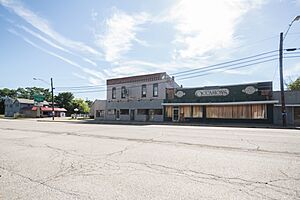
LaPaz is a small town located in Marshall County, Indiana, in the United States. It is part of North Township. In 2020, about 475 people lived there. This was a bit less than the 561 people who lived there in 2010.
Contents
History of LaPaz
The town of LaPaz was started in 1873. It was named after La Paz, a city in Bolivia. When it was founded, a train line called the Baltimore and Ohio Railroad (B&O) served the town. This railroad is now known as CSX. To honor the town, the B&O even named one of its train cars La Paz in 1949.
Geography and Location
LaPaz is found in the northern part of Marshall County, Indiana. You can find its exact spot at 41°27′26″N 86°18′29″W / 41.457159°N 86.308131°W. It is located near where the old U.S. Route 31 (now Indiana State Road 931) meets U.S. Route 6.
A newer, four-lane highway for US 31 is about 1 mile (1.6 km) east of town. This highway goes north about 17 miles (27 km) to South Bend. Plymouth, which is the main town of Marshall County, is about 8 miles (13 km) south. US 6 goes east about 8 miles (13 km) to Bremen and west about 10 miles (16 km) to Walkerton.
The town covers a total area of about 0.39 square miles (1.0 sq km), and all of it is land. LaPaz is on a small hill. This hill separates land that drains west into Pine Creek from land that drains east into the Yellow River. Both of these waterways flow west and eventually join the Kankakee River, which is part of the Illinois River system.
Population of LaPaz
The number of people living in LaPaz has changed over the years. Here's a quick look at the population from different census counts:
| Historical population | |||
|---|---|---|---|
| Census | Pop. | %± | |
| 1880 | 84 | — | |
| 1910 | 263 | — | |
| 1920 | 274 | 4.2% | |
| 1930 | 375 | 36.9% | |
| 1940 | 429 | 14.4% | |
| 1950 | 512 | 19.3% | |
| 1960 | 545 | 6.4% | |
| 1970 | 604 | 10.8% | |
| 1980 | 651 | 7.8% | |
| 1990 | 562 | −13.7% | |
| 2000 | 489 | −13.0% | |
| 2010 | 561 | 14.7% | |
| 2020 | 475 | −15.3% | |
| U.S. Decennial Census | |||
What the 2010 Census Showed
In 2010, the census counted 561 people living in LaPaz. There were 216 households, and 144 of these were families. The town had about 1476 people per square mile (570 per sq km).
About 35% of the households had children under 18 living with them. Many households were married couples living together. The average household had about 2.6 people. The average family size was about 3.2 people.
The average age of people in LaPaz was about 35 years old.
Education in LaPaz
Public schools in LaPaz are managed by the Union-North United Schools system.
Famous People from LaPaz
- Gerald Archie Mangun, a Pentecostal minister
- Donald Yeagley, an Indiana state lawmaker and a leader in labor unions
Images for kids
See also
 In Spanish: La Paz (Indiana) para niños
 | Bessie Coleman |
 | Spann Watson |
 | Jill E. Brown |
 | Sherman W. White |


