Lake Bernard Frank facts for kids
Quick facts for kids Lake Bernard Frank |
|
|---|---|

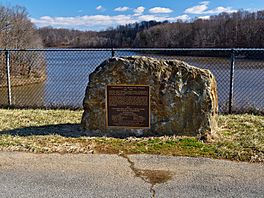
Dedication stone at Lake Bernard Frank
|
|
| Location | Derwood, Maryland |
| Coordinates | 39°06′23″N 77°06′48″W / 39.1062972°N 77.1133011°W |
| Type | reservoir |
| Primary inflows | North Branch of Rock Creek (Potomac River) |
| Primary outflows | North Branch of Rock Creek (Potomac River) |
| Catchment area | 12.2 sq mi (32 km2) |
| Basin countries | United States |
| Managing agency |
Montgomery Parks, M–NCPPC
|
| Built | 1966 |
| Construction engineer |
Natural Resources Conservation Service
|
| Max. length | 0.85 mi (1.37 km) |
| Max. width | 950 ft (290 m) |
| Surface area | 54 acres (22 ha) |
| Average depth | 12.8 ft (3.9 m) |
| Max. depth | 26.5 ft (8.1 m) |
| Water volume | 233,000,000 US gal (880,000 m3) |
| Surface elevation | 299 feet (91 m) |
Lake Bernard Frank, often called Lake Frank, is a 54-acre reservoir in Derwood, Maryland. It's located just east of Rockville. The lake was built in 1966 and was first known as Lake Norbeck.
It was later renamed to honor Bernard Frank. He was a wilderness activist and helped start The Wilderness Society. Lake Frank was created to help control floods and sediment. It also provides a place for people to enjoy nature. The lake has an earthen dam on its southern side, built in 1967. It's considered a "sister lake" to Lake Needwood. The Maryland-National Capital Park and Planning Commission (M–NCPPC) owns Lake Frank.
Contents
Exploring Lake Frank's Trails
Lake Frank is a hidden gem within Rock Creek Regional Park. You can't drive right up to the lake. Visitors need to walk or bike about a quarter of a mile from the parking lots.
Hiking and Fishing at Lake Frank
The Lake Frank & Meadowside Trails go all around the lake. This makes it a popular spot for hiking. Many local people also enjoy fishing from the shore. Remember, you need a license to fish here.
What You Can't Do at Lake Frank
To keep everyone safe and protect the lake, some activities are not allowed. You cannot go swimming in the lake. Boating and ice skating are also not permitted.
The Lakeside Trail Adventure
The main trail around Lake Frank is called the Lakeside Trail. It's a loop that is about 3.25 miles long. Most of the trail, about two-thirds, is unpaved. This part winds through the woods surrounding the lake. The rest of the trail is wider and paved.
About halfway around the trail, you'll find a creek to cross. There are some rocks that form a path like a bridge. However, if the water level is high, the creek might be too deep to cross easily.
Understanding Lake Frank's Water Quality
It's important to know about the water quality in Lake Frank. The health of the lake's water is regularly checked.
Past Concerns and Improvements
In 1998, the Maryland Department of the Environment (MDE) noted that Lake Frank had too many nutrients. This caused conditions where there was a lot of algal growth. It also led to low oxygen levels in the water. This is a process called eutrophication.
By 2002, new information showed that the lake's condition had improved. Because of this, the MDE suggested removing the lake from the "impaired waters" list.
Recent Water Safety Warnings
More recently, between 2017 and 2019, there were warnings about the lake's water. The Maryland-National Capital Park and Planning Commission warned about microcystin in the water. Microcystin is a harmful substance. It is made by some types of blue-green algae, also known as cyanobacteria. This substance can be toxic.
 | Victor J. Glover |
 | Yvonne Cagle |
 | Jeanette Epps |
 | Bernard A. Harris Jr. |


