
Lake Needwood facts for kids
Quick facts for kids Lake Needwood |
|
|---|---|

May 2006
|
|

Lake Needwood
Location in Maryland

Lake Needwood
Location in the United States
|
|
| Location | Derwood, Maryland |
| Coordinates | 39°07′16″N 77°07′46″W / 39.121238°N 77.129388°W |
| Type | reservoir |
| Primary inflows | Rock Creek |
| Primary outflows | Rock Creek |
| Catchment area | 12.8 sq mi (33 km2) |
| Basin countries | United States |
| Surface area | 75 acres (30 ha) |
| Water volume | 196,000,000 US gal (0.00074 km3) |
| Surface elevation | 324 feet (99 m) |
Lake Needwood is a 75-acre lake in Derwood, Maryland. It is a man-made lake, also called a reservoir. The lake is located in Montgomery County, Maryland, on Rock Creek.
The lake was built in 1965. Its main jobs are to control floods and stop soil from washing away. Lake Needwood also helps keep the creek's water clean. It catches sediment (dirt and tiny bits of rock) from stormwater runoff.
Lake Needwood is part of Rock Creek Regional Park. You can rent pedal boats, rowboats, and canoes here. There is also a special boat called the Needwood Queen for rides. The park has picnic areas, a visitors center, and a snack bar. You can also find hiking and biking trails, playgrounds, and an archery range. The Rock Creek Trail starts at Lake Needwood. It follows Rock Creek all the way to the Potomac River in Washington, D.C..
Contents
Lake Needwood Dam
Lake Needwood was created by building a large earthen wall called the Lake Needwood Dam. This dam is 65 feet high. It was built to hold back the waters of Rock Creek.
The dam has a main water exit and a wide emergency spillway. The emergency spillway is 185 feet wide. It helps release water safely during very heavy rains. The dam was finished in 1965. It is owned by the Maryland-National Capital Park and Planning Commission.
In 2007 and 2008, the dam was repaired. This $3 million project helped stop water from leaking through the dam's base. It also improved the tower that controls water flow.
Animals and Plants
The waters of Lake Needwood are home to many fish. You can find largemouth bass, catfish, bluegill, crappie, and trout. If you have a license, you can go fishing here.
The lake is also a temporary home for many migratory birds. These birds stop here during their long journeys. However, many Canada geese live at the lake all year. They can damage the plants and soil along the shoreline. Because of this, park staff work to manage their numbers.
The Big Flood of 2006
Sometimes, during very heavy rains, people living near the lake have to leave their homes. This is because officials worry about the dam's safety. The most recent evacuation happened on June 28, 2006. About 2,400 people had to leave their homes.
These residents stayed in temporary shelters at nearby high schools. They returned home the next day when the lake's water level dropped. During the flood, the lake was 25 feet higher than normal. Many roads around the lake were closed. Officials estimated that if the dam had broken, areas south of the lake could have flooded up to 19 feet deep.
Lake Cleaning Project
Over time, dirt and sand build up at the bottom of the lake. This is called sediment. To keep the lake healthy, this sediment needs to be removed. Until 1990, the county regularly cleaned the lake.
In 2008, plans began to clean the lake again. This project took place in 2010 and 2011. The goal was to make the water cleaner and better for boating and fishing.
In October 2010, the lake's water level was lowered by about six feet. This helped the sediment dry out before it was removed. The shallower parts of the lake were made deeper. The lake was reopened for everyone to enjoy in the summer of 2012.
Water Quality
Since 2010, tests have shown that Lake Needwood's water sometimes has a toxin called microcystin. This toxin is made by tiny living things called cyanobacteria, also known as blue-green algae. This toxin can harm the liver. Signs are posted around the lake telling people to keep their pets away from the water.
Cyanobacteria grow in the lake when there are too many nutrients. These nutrients, like nitrogen and phosphorus, come from things like too much fertilizer used in neighborhoods. This runoff flows into the lake. Warm water and slow water movement also help these harmful algae grow.
Images for kids
-
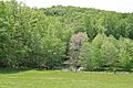
Looking downstream from the dam in 2021
-
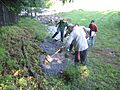
Crews shoring up the Needwood Dam in 2006
-
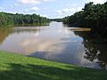
A view of the dam during the 2006 flood


