
Lake Hazen facts for kids
Quick facts for kids Lake Hazen |
|
|---|---|

NASA image
|
|

Lake Hazen
Location in Canada

Lake Hazen
Location in Nunavut
|
|
| Location | 118 km (73 mi) southwest of Alert, Nunavut |
| Coordinates | 81°48′N 71°00′W / 81.800°N 71.000°W |
| Primary inflows | Glaciers of the Eureka Uplands: Henrietta Nesmith Glacier Gilmour Glaciers |
| Primary outflows | Ruggles River |
| Catchment area | 4,900 km2 (1,900 sq mi) |
| Basin countries | Canada |
| Max. length | 74 km (46 mi) |
| Max. width | 12 km (7 mi) |
| Surface area | 537.5 km2 (207.5 sq mi) |
| Max. depth | 267 m (876 ft) |
| Water volume | 51.4×10⁹ m3 (41.7×10⁶ acre⋅ft) |
| Shore length1 | 185 km (115 mi) |
| Surface elevation | 158 m (518 ft) |
| Islands | St. John's Island |
| Settlements | Hazen Camp |
| 1 Shore length is not a well-defined measure. | |

Lake Hazen is a very large lake located in the northern part of Ellesmere Island, Nunavut, Canada. It is often called the northernmost lake in Canada. However, there are a few smaller lakes even farther north. For example, Upper Dumbell Lake is only 5.2 km (3 mi) southwest of Alert. Alert is Canada's northernmost settlement.
Lake Hazen is about 118 km (73 mi) southwest of Alert. It is the largest lake north of the Arctic Circle when you measure its volume. By surface area, it is the third largest. Only Lake Taymyr in Russia and Lake Inari in Finland are bigger.
Contents
About Lake Hazen
Lake Hazen is 74 km (46 mi) long and up to 12 km (7 mi) wide. Its total area is 537.5 km2 (207.5 sq mi). The lake stretches from southwest to northeast. It is very deep, reaching up to 269 m (883 ft). The lake holds an estimated 51.4 cubic kilometers of water. Its shoreline is 185 km (115 mi) long. The lake sits 158 m (518 ft) above sea level.
Islands in the Lake
Lake Hazen has several islands. The biggest one is Johns Island. It is 7 km (4.3 mi) long and less than 1 km (0.62 mi) wide. Like the lake, it also runs from southwest to northeast. Other islands include Gatter Island, Clay Island, Whisler Island, and Dyas Island.
Water Sources and Flow
The lake is covered by ice for about ten months each year. It gets its water from glaciers in the nearby Eureka Uplands. These glaciers include Henrietta Nesmith and the Gilmour Glaciers. The Eureka Uplands are mountains made of ancient rocks. They rise up to 2,500 m (8,200 ft) above sea level. Lake Hazen drains into the 15 km (9.3 mi) long Ruggles River. This river flows into Chandler Fjord on the east coast of Ellesmere Island. The lake is surrounded by the Arctic Cordillera mountain range.
Climate Around Lake Hazen
The area around Lake Hazen is special. It is like a warm spot, or "thermal oasis," in the middle of a polar desert. In summer, temperatures can reach up to 20 °C (68 °F). This warmer climate helps plants and animals to live there.
Quttinirpaaq National Park
Lake Hazen is an important part of Quttinirpaaq National Park. This park protects the unique Arctic environment. It is a place where nature is preserved.
History and Discovery
People have lived near Lake Hazen for a long time. In 2004, artifacts from the Thule civilization were found near the lake. The Thule people lived before the Inuit.
The lake was discovered by Adolphus Greely in 1882. He was on an expedition from 1881 to 1883. Greely named the lake after General William Babcock Hazen. General Hazen had helped organize Greely's expedition.
Later, in 1957, Camp Hazen was set up on the northern shore of the lake. This happened during the International Geophysical Year (IGY). Since then, many scientists have used the camp for their research.
Wildlife in Lake Hazen
Lake Hazen is home to Arctic char. Arctic char are a type of fish. There are two different kinds, or "morphotypes," of Arctic char in the lake: a larger one and a smaller one. Studies in the 1990s suggested these fish do not travel to the ocean. However, Inuit traditional knowledge says that some Arctic char do go to the ocean.
Visiting Lake Hazen
Hikers can start their trips right at Lake Hazen. Another starting point is the Tanquary Fiord warden station. This station is at Tanquary Fiord Airport, about 70 km (43 mi) southwest of the lake.
Images for kids
-
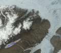
NASA image of Lake Hazen
-
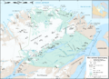
Map showing Lake Hazen inside Quttinirpaaq National Park
See also
 In Spanish: Lago Hazen para niños
