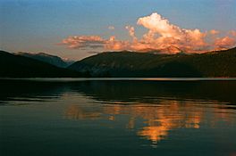
Lake Thomas A Edison facts for kids
Quick facts for kids Lake Thomas A Edison |
|
|---|---|
 |
|
| Location | Fresno County, California |
| Coordinates | 37°22′58″N 118°58′34″W / 37.38278°N 118.97611°W |
| Type | reservoir |
| Primary inflows | Mono Creek, Cold Creek |
| Primary outflows | Mono Creek |
| Catchment area | 88 square miles (230 km2) |
| Basin countries | United States |
| Max. length | 3.5 miles (5.6 km) |
| Max. width | 1 mile (1.6 km) |
| Surface area | 1,878 acres (760 ha) |
| Average depth | 67 feet (20 m) |
| Water volume | 125,000 acre-feet (154,000,000 m3) |
| Shore length1 | 13 miles (21 km) |
| Surface elevation | 7,648 feet (2,331 m) |
| 1 Shore length is not a well-defined measure. | |
Lake Thomas A Edison is a large, man-made lake in Fresno County, California. It is also known as Thomas A. Edison Lake or just Edison Lake. This beautiful lake is found within the Sierra National Forest and close to the famous Pacific Crest Trail.
The lake was created when the Vermilion Valley Dam was finished in 1954. This dam holds back the water, forming the lake. Both the lake and the dam are important parts of the Big Creek Hydroelectric Project. This project uses water to make electricity.
Contents
How Water Flows In and Out
Lake Thomas A Edison gets its water from Mono Creek and Cold Creek. Water from the lake then flows out into Mono Creek. Mono Creek is a smaller stream that eventually joins the South Fork San Joaquin River.
Some of the lake's water is also sent through a special path called the Ward Tunnel. This tunnel moves water to another lake nearby, Huntington Lake.
About Vermilion Valley Dam
| Vermilion Valley Dam | |
|---|---|
| Country | United States |
| Location | Fresno County, California |
| Coordinates | 37°22′12″N 118°59′14″W / 37.37000°N 118.98722°W |
| Opening date | 1954 |
| Owner(s) | Southern California Edison |
| Dam and spillways | |
| Type of dam | Earthen |
| Impounds | Mono Creek |
| Height | 167 feet (51 m) |
| Length | 4,234 feet (1,291 m) |
| Elevation at crest | 7,650.5 feet (2,331.9 m) |
| Width (crest) | 20 feet (6.1 m) |
| Dam volume | 4,200,000 cubic yards (3,200,000 m3) |
| Reservoir | |
| Creates | Lake Thomas A Edison |
| Total capacity | 125,000 acre-feet (154,000,000 m3) |
| Catchment area | 88 square miles (230 km2) |
| Maximum length | 3.5 miles (5.6 km) |
| Maximum width | 1 mile (1.6 km) |
The Vermilion Valley Dam is an earthen dam. This means it is built mostly from soil, sand, and rock. It is very long, stretching about 4,234 feet (1,291 m), and stands 167 feet (51 m) high. The dam is owned by Southern California Edison, an energy company.
Fun Things to Do
Lake Thomas A Edison is a great place for outdoor fun! It is located in the beautiful Sierra National Forest and is a popular spot for people hiking the Pacific Crest Trail.
At the lake, you can enjoy many activities, including:
- Boating
- Camping
- Fishing
- Swimming
- Canoeing
- Kayaking
- Horseback riding
The Vermilion Valley Resort and Vermillion Campground are right by the lake, making it easy to enjoy all these activities.
How to Get There
Getting to Lake Thomas A Edison takes about three hours by car from Fresno. You take State Route 168 east towards Huntington Lake. Then, you turn east onto Kaiser Pass Road.
Be aware that Kaiser Pass Road goes over Kaiser Pass, which is very high at 9,175 feet (2,797 m). This road closes during the winter months because of snow. The United States Forest Service advises that this road is not good for large vehicles like buses, big motor homes, or cars pulling trailers.
There is also a ferry that crosses the lake twice a day. This ferry connects the Vermilion Valley Resort with the start of the John Muir Wilderness trail. It helps hikers get to and from the famous John Muir Trail and Pacific Crest Trail.
Where the Name Comes From
The lake was named after the famous American inventor, Thomas Edison. This was done to celebrate 75 years since he invented the incandescent light bulb. The dam itself was named after the valley it flooded, which was known for its reddish soil, like the color Vermilion.
 | May Edward Chinn |
 | Rebecca Cole |
 | Alexa Canady |
 | Dorothy Lavinia Brown |


