Latimer, Leicester facts for kids
Quick facts for kids Latimer |
|
|---|---|
 |
|
| Population | 11,583 |
| Unitary authority | |
| Ceremonial county | |
| Region | |
| Country | England |
| Sovereign state | United Kingdom |
| Post town | LEICESTER |
| Postcode district | LE4 |
| Dialling code | 0116 |
| Police | Leicestershire |
| Fire | Leicestershire |
| Ambulance | East Midlands |
| EU Parliament | East Midlands |
| UK Parliament |
|
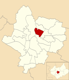
Latimer was an area in the city of Leicester, England. It was once a special division called an electoral ward. This meant it was a specific area used for voting and local government. Latimer was mostly a living area known as the St Marks suburb.
How Latimer Was Built
The St Marks area was built around 1960. This happened after a big project in Leicester called "slum clearance." This project aimed to replace old, rundown houses with new, modern homes for people.
Where Was Latimer Located?
Latimer was surrounded by other areas of Leicester. To the north was Belgrave. To the south was Spinney Hills. The Abbey area was to the west. And to the east was North Evington.
Who Lived in Latimer?
The Latimer area had a population of 11,583 people. The average age of residents was about 35 years old. This was similar to the average age across all of Leicester. Latimer was known for having many residents of Indian heritage. About 74% of the people in Latimer were of Indian descent. This was much higher than the city average of 25%. Only about 16% of Latimer residents were people born in Britain.
 | George Robert Carruthers |
 | Patricia Bath |
 | Jan Ernst Matzeliger |
 | Alexander Miles |

