Laurel River facts for kids
Quick facts for kids Laurel River |
|
|---|---|
 |
|
| Physical characteristics | |
| River mouth | Cumberland River 722 ft (220 m) |
| Length | 42 mi (68 km) |
| Basin features | |
| Progression | Cumberland—Ohio—Mississippi |
| Basin size | 291 sq mi (750 km2) |
The Laurel River is a river in southeast Kentucky, United States. It flows for about 42-mile (68 km) (68 km). This river is a branch, or tributary, of the Cumberland River.
The Laurel River flows through a countryside area. This region is in the foothills of the Appalachian Mountains. It passes through parts of Whitley and Laurel Counties.
Where the River Flows
The town of Corbin is located along the Laurel River. It's about 15 miles (24 km) (24 km) east of where the Laurel River joins the Cumberland River. A smaller river, the Little Laurel River, also meets the Laurel River nearby.
Laurel River Dam and Lake
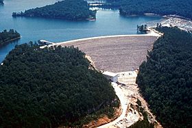
Near where the Laurel River ends, there is a large dam called the Laurel River Dam. This dam creates a big lake known as Laurel River Lake.
The U.S. Army Corps of Engineers built this dam. It was finished in 1974. The main reason for the dam is to control floods. It also helps to produce some hydroelectricity, which is electricity made from moving water.
How the River Got its Name
The Laurel River likely got its name from the many laurel plants. These plants grew thickly along its banks.
 | Shirley Ann Jackson |
 | Garett Morgan |
 | J. Ernest Wilkins Jr. |
 | Elijah McCoy |

