Laytonville, California facts for kids
Quick facts for kids
Laytonville
Tintaahding
|
|
|---|---|

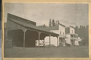
Laytonville in 1910
|
|

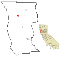
Location in Mendocino County and the state of California
|
|
| Country | |
| State | |
| County | Mendocino |
| Area | |
| • Total | 5.433 sq mi (14.07 km2) |
| • Land | 5.370 sq mi (13.91 km2) |
| • Water | 0.063 sq mi (0.16 km2) 1.16% |
| Elevation | 1,670 ft (509 m) |
| Population
(2020)
|
|
| • Total | 1,152 |
| • Density | 214.5/sq mi (82.8/km2) |
| Time zone | UTC-8 (Pacific (PST)) |
| • Summer (DST) | UTC-7 (PDT) |
| ZIP codes |
95417, 95454
|
| Area code(s) | 707 |
| FIPS code | 06-40928 |
| GNIS feature ID | 1658951 |
Laytonville is a small community located in Mendocino County, California, in the United States. It is called a census-designated place (CDP). This means it's an area identified by the government for collecting statistics, but it doesn't have its own city government.
Laytonville is about 23 miles (37 km) north-northwest of Willits. It sits at an elevation of about 1,670 feet (509 meters) above sea level. In 2020, about 1,152 people lived there.
Contents
Where is Laytonville?
Laytonville is found at the coordinates 39°41′18″N 123°28′58″W.
The area of Laytonville is about 5.4 square miles (14 square kilometers). Most of this area is land, with a small part, about 0.1 square miles (0.26 square kilometers), being water.
A few miles south of Laytonville, you can find the beginning of the South Fork Eel River. This river is a branch that flows into the larger Eel River.
A Look Back in Time: Laytonville's History
Laytonville was started by a man named Frank B. Layton. He came from Nova Scotia, a province in Canada.
In 1874, Frank Layton built a blacksmith shop and a house in this spot. This was the very beginning of the town. The first post office in Laytonville opened a few years later, in 1879.
Population Changes in Laytonville
| Historical population | |||
|---|---|---|---|
| Census | Pop. | %± | |
| 1980 | 1,096 | — | |
| 1990 | 1,133 | 3.4% | |
| 2000 | 1,301 | 14.8% | |
| 2010 | 1,227 | −5.7% | |
| 2020 | 1,152 | −6.1% | |
| US Census U.S Census 1880-1980, | |||
Over the years, the number of people living in Laytonville has changed. In 2010, there were 1,227 residents. Most people living in Laytonville were White, with a significant number of Native American residents. About 11.5% of the population identified as Hispanic or Latino.
The population included people of all ages. About 22% were under 18 years old, and about 12% were 65 years or older. The average age in Laytonville was 40 years old.
In 2000, the population was 1,301 people. The community had a mix of different backgrounds, with about 75% White residents and 15% Native American residents. About 8% of the population was Hispanic or Latino.
Getting Around Laytonville
If you need to travel to or from Laytonville, you can use the Amtrak Thruway 7 bus. This bus service connects Laytonville to other places every day.
The bus stops right on Highway 101 in Laytonville. You can travel south to Martinez or north to Arcata. From Martinez, you can connect to other Amtrak train services.
Famous People from Laytonville
- Anna M. Morrison Reed (1849/50-1921) – She was a talented writer, speaker, and a strong supporter of women's right to vote (a suffragist). She also worked as an editor and publisher for a newspaper and a magazine.
See also
 In Spanish: Laytonville para niños


