Lennox, California facts for kids
Quick facts for kids
Lennox, California
|
|
|---|---|

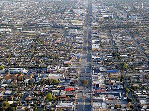
Aerial view of Hawthorne Boulevard in Lennox in 2024
|
|

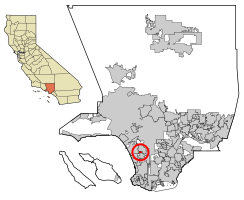
Location of Lennox in Los Angeles County, California.
|
|
| Country | |
| State | |
| County | |
| Area | |
| • Total | 1.093 sq mi (2.832 km2) |
| • Land | 1.093 sq mi (2.832 km2) |
| • Water | 0 sq mi (0 km2) 0% |
| Elevation | 72 ft (22 m) |
| Population
(2010)
|
|
| • Total | 22,753 |
| • Density | 20,817/sq mi (8,034.3/km2) |
| Time zone | UTC−8 (PST) |
| • Summer (DST) | UTC−7 (PDT) |
| ZIP Code |
90304
|
| Area code(s) | 310 |
| FIPS code | 06-41180 |
| GNIS feature ID | 1652743 |
Lennox is a community located in the South Bay area of Los Angeles County, California. It's known as a census-designated place (CDP). This means it's a special area identified by the U.S. Census Bureau for statistical purposes.
In 2010, about 22,753 people lived in Lennox. This number was a little lower than the 22,950 people counted in 2000.
Contents
Geography of Lennox
Lennox is surrounded by several important roads and cities. To the north, Century Boulevard forms a boundary with Inglewood and Los Angeles. On its west side, you'll find Interstate 405, also known as the San Diego Freeway. To the south, Interstate 105 (the Glenn Anderson Freeway) marks another border.
Parts of its eastern edge touch Inglewood, along Hawthorne Boulevard and Prairie Avenue. The community is located right under the flight path for planes landing at Los Angeles International Airport (LAX). This means planes fly low over Lennox as they approach the airport. The city of Hawthorne is also nearby.
The United States Census Bureau states that Lennox covers about 1.1 square miles (2.8 square kilometers) of land. There is no water area within its boundaries.
People and Population
| Historical population | |||
|---|---|---|---|
| Census | Pop. | %± | |
| 1960 | 31,224 | — | |
| 1970 | 16,121 | −48.4% | |
| 1980 | 18,445 | 14.4% | |
| 1990 | 22,757 | 23.4% | |
| 2000 | 22,950 | 0.8% | |
| 2010 | 22,753 | −0.9% | |
Population in 2010
In 2010, Lennox had a population of 22,753 people. Most people in Lennox, about 93%, identified as Hispanic or Latino. The community was also home to people of many different backgrounds, including White, African American, Native American, Asian, and Pacific Islander residents.
Most people in Lennox lived in regular homes. There were about 5,250 households. Many of these households, about 63%, had children under 18 living there. The average household had about 4.33 people.
The population of Lennox was quite young. About 33% of residents were under 18 years old. The average age in Lennox was 27.7 years.
Many homes in Lennox were rented, about 70%. The remaining 30% were owned by the people living in them. In the years leading up to 2013, the average household income in Lennox was around $37,659.
Population in 2000
In 2000, Lennox had a population of 22,950 people. At that time, about 90% of the population was Hispanic or Latino. The community also included people from various other racial backgrounds.
About 64% of households had children under 18. The average household size was 4.55 people. The population was also very young, with about 39% of residents being under 18 years old. The average age was 24 years.
Lennox in the 1980s
By the mid-1980s, Lennox was sometimes called "Little Tijuana" by people in the Los Angeles area. This nickname came about because many new immigrants, especially from Hispanic communities, had moved to Lennox. Many families lived together in single-family houses during this time.
Education in Lennox
Lennox has its own school districts that serve the community. The Lennox Elementary School District handles elementary education. The Centinela Valley Union High School District is responsible for high schools.
Together, these districts operate 10 schools. This includes two early education centers, five elementary schools, one middle school, and several high schools. Some of the high schools serving Lennox are:
- Lennox Mathematics, Science & Technology Academy
- Animo Leadership Charter High School
Before 1982, the Centinela Valley district also ran a school called Lennox High School.
Public Services
The Los Angeles County Sheriff's Department (LASD) helps keep Lennox safe. They operate the South Los Angeles Station, which serves the Lennox area.
For health services, the Los Angeles County Department of Health Services runs the Curtis Tucker Health Center. This center is located in Inglewood and provides healthcare for residents of Lennox.
Air Quality and Flight Paths
Because Lennox is located directly under the flight path for planes landing at Los Angeles International Airport (LAX), there have been studies about air quality in the area. In 2014, a study looked at air pollution. It found that tiny particles, called ultrafine particles, from planes taking off and landing were more common than previously thought. These particles can affect air quality.
See also
 In Spanish: Lennox (California) para niños
 | Delilah Pierce |
 | Gordon Parks |
 | Augusta Savage |
 | Charles Ethan Porter |


