Lewis Hills facts for kids
Quick facts for kids Lewis Hills |
|
|---|---|

Fox Island River Valley in Lewis Hills
|
|
| Highest point | |
| Peak | The Cabox |
| Elevation | 814 m (2,671 ft) |
| Geography | |
| Country | Canada |
| Province | Newfoundland and Labrador |
| Range coordinates | 48°47.9′N 58°30.4′W / 48.7983°N 58.5067°W |
| Parent range | Appalachian Mountains, Long Range Mountains |
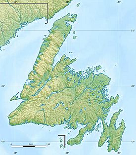
The Lewis Hills are a part of the Long Range Mountains. You can find them on the west coast of Newfoundland, right next to the Gulf of Saint Lawrence.
These hills are a special place for geology. They are made of unique rocks called an ophiolite and Peridotite complex. This means they have rocks that usually form deep inside the Earth's crust or even in the mantle, but somehow ended up on the surface! The Lewis Hills are one of four such areas in a famous geological region called the Humber Arm Allochthon.
You can find the Lewis Hills between the town of Stephenville in the south and the city of Corner Brook in the north.
Exploring the Lewis Hills
The Lewis Hills are a fantastic spot for hiking and exploring the wilderness. It's a great place to go if you love nature and want to see some amazing views.
One of the best ways to hike here is by using the International Appalachian Trail. This trail has two main starting points. The southern start is near the end of Cold Brook Road. The northern start is at the end of Logger School Road. Both offer great access to the trails.
The Cabox: Newfoundland's Highest Point
The highest point on the island of Newfoundland is a peak called The Cabox. It stands tall at 814 meters (2,671 feet) above sea level.
The Cabox is located right within the Lewis Hills. Its exact spot is at 48°49′59″N 58°29′03″W / 48.83306°N 58.48417°W. Reaching the top of The Cabox is a big achievement for hikers!
 | Jessica Watkins |
 | Robert Henry Lawrence Jr. |
 | Mae Jemison |
 | Sian Proctor |
 | Guion Bluford |


