Lexington, Georgia facts for kids
Quick facts for kids
Lexington, Georgia
|
|
|---|---|

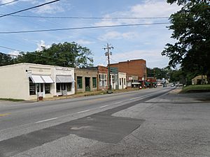
A part of Main Street looking East while standing in front of the courthouse.
|
|

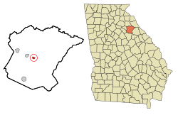
Location in Oglethorpe County and the state of Georgia
|
|
| Country | United States |
| State | Georgia |
| County | Oglethorpe |
| Area | |
| • Total | 0.55 sq mi (1.42 km2) |
| • Land | 0.55 sq mi (1.42 km2) |
| • Water | 0.00 sq mi (0.00 km2) |
| Elevation | 702 ft (214 m) |
| Population
(2020)
|
|
| • Total | 203 |
| • Density | 370.44/sq mi (143.04/km2) |
| Time zone | UTC-5 (Eastern (EST)) |
| • Summer (DST) | UTC-4 (EDT) |
| ZIP code |
30648
|
| Area code(s) | 706 |
| FIPS code | 13-46188 |
| GNIS feature ID | 0316791 |
Lexington is a small city in Georgia, United States. It is the main town, or county seat, of Oglethorpe County. In 2020, about 203 people lived there. Lexington is also home to Shaking Rock Park, a cool place to visit.
Contents
History of Lexington
Lexington was started in the year 1800. In the same year, it became the main town for Oglethorpe County, taking over from a place called Philomath. Lexington officially became a town in 1806. It was named after Lexington, Massachusetts, a famous place in American history.
Geography and Location
Lexington is located in a specific spot in Georgia. Its coordinates are 33.870351 degrees North and -83.110916 degrees West. Several important roads pass through the city. These include U.S. Route 78, Georgia State Route 22, and Georgia State Route 77.
U.S. Route 78 goes southeast to Washington and northwest to Athens. Georgia State Route 22 also goes through the city, leading north to Comer and southeast to Crawfordville. Georgia State Route 77 heads northeast to Elberton and south to Union Point.
The United States Census Bureau says that Lexington covers about 0.5 square miles (1.42 square kilometers). All of this area is land, with no water.
Climate in Lexington
| Climate data for Lexington, Georgia, 1991–2020 normals, extremes 2004–2019 | |||||||||||||
|---|---|---|---|---|---|---|---|---|---|---|---|---|---|
| Month | Jan | Feb | Mar | Apr | May | Jun | Jul | Aug | Sep | Oct | Nov | Dec | Year |
| Record high °F (°C) | 78 (26) |
82 (28) |
89 (32) |
91 (33) |
96 (36) |
108 (42) |
110 (43) |
106 (41) |
99 (37) |
94 (34) |
86 (30) |
79 (26) |
110 (43) |
| Mean daily maximum °F (°C) | 54.8 (12.7) |
58.1 (14.5) |
65.8 (18.8) |
73.6 (23.1) |
81.1 (27.3) |
88.2 (31.2) |
90.8 (32.7) |
88.4 (31.3) |
84.9 (29.4) |
75.5 (24.2) |
64.8 (18.2) |
56.8 (13.8) |
73.6 (23.1) |
| Daily mean °F (°C) | 43.4 (6.3) |
46.9 (8.3) |
53.0 (11.7) |
60.6 (15.9) |
68.9 (20.5) |
76.6 (24.8) |
79.9 (26.6) |
78.1 (25.6) |
73.2 (22.9) |
62.9 (17.2) |
52.2 (11.2) |
45.7 (7.6) |
61.8 (16.5) |
| Mean daily minimum °F (°C) | 32.0 (0.0) |
35.8 (2.1) |
40.3 (4.6) |
47.7 (8.7) |
56.6 (13.7) |
65.0 (18.3) |
69.0 (20.6) |
67.8 (19.9) |
61.5 (16.4) |
50.4 (10.2) |
39.6 (4.2) |
34.6 (1.4) |
50.0 (10.0) |
| Record low °F (°C) | 6 (−14) |
12 (−11) |
20 (−7) |
26 (−3) |
37 (3) |
53 (12) |
55 (13) |
55 (13) |
45 (7) |
30 (−1) |
17 (−8) |
14 (−10) |
6 (−14) |
| Average precipitation inches (mm) | 4.30 (109) |
4.96 (126) |
4.72 (120) |
3.61 (92) |
3.30 (84) |
4.50 (114) |
3.93 (100) |
4.78 (121) |
3.83 (97) |
2.97 (75) |
3.76 (96) |
4.87 (124) |
49.53 (1,258) |
| Average snowfall inches (cm) | 0.0 (0.0) |
0.2 (0.51) |
0.2 (0.51) |
0.0 (0.0) |
0.0 (0.0) |
0.0 (0.0) |
0.0 (0.0) |
0.0 (0.0) |
0.0 (0.0) |
0.0 (0.0) |
0.0 (0.0) |
0.1 (0.25) |
0.5 (1.27) |
| Average precipitation days (≥ 0.01 in) | 8.9 | 9.1 | 9.0 | 7.4 | 8.3 | 9.5 | 8.8 | 8.7 | 6.4 | 5.8 | 7.5 | 9.2 | 98.6 |
| Average snowy days (≥ 0.1 in) | 0.2 | 0.1 | 0.1 | 0.0 | 0.0 | 0.0 | 0.0 | 0.0 | 0.0 | 0.0 | 0.0 | 0.1 | 0.5 |
| Source 1: NOAA | |||||||||||||
| Source 2: National Weather Service | |||||||||||||
Lexington has a climate with warm summers and mild winters. The weather box above shows details like average temperatures and how much rain falls each month. It also lists the highest and lowest temperatures ever recorded.
Population and People
| Historical population | |||
|---|---|---|---|
| Census | Pop. | %± | |
| 1810 | 222 | — | |
| 1880 | 441 | — | |
| 1900 | 635 | — | |
| 1910 | 545 | −14.2% | |
| 1920 | 469 | −13.9% | |
| 1930 | 455 | −3.0% | |
| 1940 | 517 | 13.6% | |
| 1950 | 514 | −0.6% | |
| 1960 | 376 | −26.8% | |
| 1970 | 322 | −14.4% | |
| 1980 | 278 | −13.7% | |
| 1990 | 230 | −17.3% | |
| 2000 | 239 | 3.9% | |
| 2010 | 228 | −4.6% | |
| 2020 | 203 | −11.0% | |
| U.S. Decennial Census | |||
In 2000, there were 239 people living in Lexington. These people lived in 101 homes, and 65 of these were families. The city had about 439 people per square mile.
About 23.8% of homes had children under 18. Many homes (44.6%) were married couples. About 11.9% of homes had someone living alone who was 65 or older. The average family size was 2.82 people.
The people in Lexington were of different ages. About 19.2% were under 18, and 15.5% were 65 or older. The average age in the city was 40 years old.
Education in Lexington
Lexington is part of the Oglethorpe County School District. This district provides schooling from pre-school all the way to twelfth grade.
The district has several schools:
- Oglethorpe County Primary School (for pre-kindergarten to 2nd grade)
- Oglethorpe County Elementary School (for 3rd to 5th grade)
- Oglethorpe County Middle School (for 6th to 8th grade)
- Oglethorpe County High School (for 9th to 12th grade)
There are about 145 full-time teachers in the district, teaching over 2,281 students.
Notable People from Lexington
Many interesting people have connections to Lexington:
- Nathan Crawford Barnett: He was a member of the Georgia House of Representatives and served as the Georgia Secretary of State for over 30 years. He grew up in Lexington and went to Lexington Academy.
- Clifford Cleveland Brooks: Born in Lexington in 1886, he was a farmer and politician. He was a member of the Louisiana State Senate from 1924 to 1932.
- William Harris Crawford: A well-known lawyer and politician.
- George Rockingham Gilmer: A statesman and politician.
- Joseph Henry Lumpkin: A lawyer.
- Wilson Lumpkin: Another lawyer and politician.
- Stephen Upson: Also a lawyer and politician.
See also
 In Spanish: Lexington (Georgia) para niños
 | Selma Burke |
 | Pauline Powell Burns |
 | Frederick J. Brown |
 | Robert Blackburn |

