Licking Run (Beaver Run tributary) facts for kids
Quick facts for kids Licking Run |
|
|---|---|

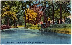
Licking Run Creek, Memorial Park, Quakertown, Pa. postcard
|
|
|
Licking Run
|
|
| Country | United States |
| State | Pennsylvania |
| County | Bucks |
| Township, Borough | Richland, Quakertown |
| Physical characteristics | |
| Main source | 600 feet (180 m) 40°27′26″N 75°21′34″W / 40.45722°N 75.35944°W |
| River mouth | 490 feet (150 m) 40°26′25″N 75°19′24″W / 40.44028°N 75.32333°W |
| Length | 3.36 miles (5.41 km) |
| Basin features | |
| Progression | Licking Run → Beaver Run → Tohickon Creek → Delaware River → Delaware Bay |
| River system | Delaware River |
| Bridges | West Pumping Station Road Kelly Drive Sunshine Drive Golden Gate Drive West Mill Street North Main Street (California Road) North 9th Street North 4th Street Pennsylvania Route 212 (North Hellertown Avenue) North Ambler Street North Penrose Street (foot bridge) Erie Road |
Licking Run is a small stream, also called a tributary, that flows into Beaver Run. It's located in Richland Township and Quakertown, both in Bucks County, Pennsylvania, in the United States.
Contents
The Journey of Licking Run
Licking Run starts in Richland Township. It begins with two small branches. These branches are about 600 feet (180 m) above sea level.
Where the Stream Begins
The two branches flow south for about a mile. They join together just west of Quakertown. From there, the main stream turns east. It picks up another small branch on its left side.
Flowing Through Quakertown
The stream then continues its journey through Quakertown. It flows along the southern edge of Memorial Park. As it reaches the eastern part of Quakertown, it turns south.
Joining Beaver Run
Finally, Licking Run meets Beaver Run. This meeting point is about 490 feet (150 m) above sea level. The stream drops about 32.74 feet for every mile it travels.
What the Ground is Made Of
Licking Run flows over an area called the Brunswick Formation. This area is part of the Piedmont Province. It's a region known for its rolling hills and valleys.
Brunswick Formation Rocks
The Brunswick Formation is made of sedimentary rock. These rocks were formed a very long time ago, during the Jurassic and Triassic periods. They are made from layers of mud, silt, and clay that hardened over time.
Types of Rocks You Might Find
You can find different kinds of rocks here. These include mudstone, siltstone, and shale. Shale often has colors like green, brown, or reddish-brown. The rocks also contain minerals like argillite and hornfels.
Bridges Over Licking Run
Many bridges cross over Licking Run. These bridges help people and cars get around. Here are some of the roads and paths that cross the stream:
- West Pumping Station Road
- Kelly Drive
- Sunshine Drive
- Golden Gate Drive
- West Mill Street
- North Main Street (also known as California Road)
- North 9th Street
- North Main Street
- Pennsylvania Route 212 (North Hellertown Avenue)
- North Ambler Street
- North Penrose Street (this is a bridge for people walking)
- Erie Road
 | Charles R. Drew |
 | Benjamin Banneker |
 | Jane C. Wright |
 | Roger Arliner Young |


