Limestone Township, Michigan facts for kids
Quick facts for kids
Limestone Township, Michigan
|
|
|---|---|

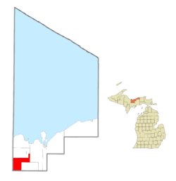
Location within Alger County
|
|
| Country | |
| State | |
| County | |
| Area | |
| • Total | 75.2 sq mi (194.7 km2) |
| • Land | 74.2 sq mi (192.2 km2) |
| • Water | 0.9 sq mi (2.4 km2) |
| Elevation | 932 ft (284 m) |
| Population
(2020)
|
|
| • Total | 392 |
| • Density | 5.90/sq mi (2.28/km2) |
| Time zone | UTC-5 (Eastern (EST)) |
| • Summer (DST) | UTC-4 (EDT) |
| ZIP code(s) | |
| Area code(s) | 906 |
| FIPS code | 26-47540 |
| GNIS feature ID | 1626617 |
Limestone Township is a small community located in Alger County, Michigan, in the United States. It is known as a civil township, which is a type of local government area. In 2020, about 392 people lived here.
Contents
Exploring Limestone Township's Geography
Limestone Township covers about 194.7 square kilometers (about 75 square miles). Most of this area is land, with a small part (about 2.4 square kilometers) being water.
Communities Within Limestone Township
There are no big cities or towns with their own governments in Limestone Township. Instead, there are several smaller, historic places and unincorporated communities. These are places where people live, but they don't have their own city council or mayor.
- Diffin is a small place located south of the West Branch Whitefish River. It's also near US 41. Long ago, it was a meeting point for two old railroad lines. The name "Diffin" was chosen because it was short and easy to say.
- Ladoga is a historic spot that used to be a sawmill settlement. Sawmills are places where logs are cut into lumber. It was located along the Chicago and North Western Transportation Company railway. This community was named after Lake Ladoga, a large lake in Russia.
- Limestone is an unincorporated community on M-67, about 10 kilometers (6 miles) south of Chatham. People first settled here in 1889. A post office opened in 1892, and it was named "Limestone" because of the limestone found in Johnson Creek, which flows through the area. The post office closed in 1984.
- Kiva is another unincorporated community. The first white settlers, the Huber family, arrived here in 1880. It was first called "Whitefish" because it was on the Whitefish River. Later, it was known as "West Limestone." In 1915, a post office was opened and named Kiva, which was a shorter version of the first postmaster's name, Sigrid Kivimaki. The post office closed in 1967.
- Traunik is an unincorporated community where county highways H-01 and H-44 meet. It's also on a branch of the Soo Line Railroad. George Nickel settled here around 1895. The community grew quickly around 1910 when many Slovene immigrants came to work in the local lumber camps. It was first called "Buckeye Landing" or "Buckeye Spur." In 1927, the storekeeper Louis Mikulich became the first postmaster and renamed the town Traunik. He named it after a village in Slovenia called Travnik, where many of the settlers came from.
People and Population in Limestone Township
| Historical population | |||
|---|---|---|---|
| Census | Pop. | %± | |
| 1960 | 330 | — | |
| 1970 | 302 | −8.5% | |
| 1980 | 373 | 23.5% | |
| 1990 | 334 | −10.5% | |
| 2000 | 407 | 21.9% | |
| 2010 | 438 | 7.6% | |
| Source: Census Bureau. Census 1960- 2000, 2010. | |||
In 2000, there were 407 people living in Limestone Township. By 2020, the population was 392.
Who Lives in Limestone Township?
In 2000, most of the people living in the township were White (about 94.8%). There were also small percentages of African American, Native American, and people from other races or mixed races. About 1.7% of the population identified as Hispanic or Latino.
Many residents have family backgrounds from different parts of the world. In 2000, some of the main ancestries included:
- United States or American (17.0%)
- Finnish (13.6%)
- German (12.9%)
- Polish (10.6%)
- French (9.1%)
- English (6.1%)
Households and Families
In 2000, there were 174 households in the township. A household is a group of people living together in one home.
- About 25% of these households had children under 18 living with them.
- Most households (about 63.8%) were married couples living together.
- About 24% of all households were made up of individuals living alone.
- About 8.6% of households had someone living alone who was 65 years old or older.
The average household had about 2.34 people, and the average family had about 2.77 people.
Age and Income
In 2000, the population was spread out by age:
- About 21.4% were under 18 years old.
- About 34.9% were between 45 and 64 years old.
- About 15.7% were 65 years old or older.
The average age of people in the township was 46 years.
The median income for a household in 2000 was $35,938. This means half the households earned more than this amount, and half earned less. For families, the median income was $37,981.
See also
 In Spanish: Municipio de Limestone (Míchigan) para niños


