Lincoln County, Idaho facts for kids
Quick facts for kids
Lincoln County
|
||
|---|---|---|

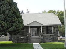
American Legion Hall (Shoshone, Idaho)
|
||
|
||

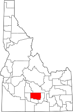
Location within the U.S. state of Idaho
|
||
 Idaho's location within the U.S. |
||
| Country | ||
| State | ||
| Founded | March 18, 1895 | |
| Named for | Abraham Lincoln | |
| Seat | Shoshone | |
| Largest city | Shoshone | |
| Area | ||
| • Total | 1,206 sq mi (3,120 km2) | |
| • Land | 1,201 sq mi (3,110 km2) | |
| • Water | 4.5 sq mi (12 km2) 0.4% | |
| Population
(2020)
|
||
| • Total | 5,127 | |
| • Estimate
(2023)
|
5,450 |
|
| • Density | 4.2512/sq mi (1.6414/km2) | |
| Time zone | UTC−7 (Mountain) | |
| • Summer (DST) | UTC−6 (MDT) | |
| Congressional district | 2nd | |
Lincoln County is a county in the state of Idaho, USA. It's like a special district within the state. In 2020, about 5,127 people lived here. The main town and biggest city is Shoshone.
This county got its name from President Abraham Lincoln. He was president when the Idaho Territory was first created in 1863. Lincoln County was officially formed on March 18, 1895. It was made from parts of Blaine County. Over time, parts of Lincoln County were used to create other counties, like Gooding County and Minidoka County. The county got its current shape in 1919.
Contents
Geography of Lincoln County
Lincoln County is a big area! The U.S. Census Bureau says it covers about 1,206 square miles. Most of this land is dry, but about 4.5 square miles is water.
Neighboring Counties
Lincoln County shares its borders with several other counties:
- Camas County to the northwest
- Blaine County to the north
- Minidoka County to the east
- Jerome County to the south
- Gooding County to the west
Main Roads in the County
Several important roads run through Lincoln County, helping people travel and move goods.
Protected Natural Areas
Part of the Craters of the Moon National Monument and Preserve is located in Lincoln County. This is a special place protected for its unique volcanic landscape.
People of Lincoln County
| Historical population | |||
|---|---|---|---|
| Census | Pop. | %± | |
| 1900 | 1,784 | — | |
| 1910 | 12,676 | 610.5% | |
| 1920 | 3,446 | −72.8% | |
| 1930 | 3,242 | −5.9% | |
| 1940 | 4,230 | 30.5% | |
| 1950 | 4,256 | 0.6% | |
| 1960 | 3,686 | −13.4% | |
| 1970 | 3,057 | −17.1% | |
| 1980 | 3,436 | 12.4% | |
| 1990 | 3,308 | −3.7% | |
| 2000 | 4,044 | 22.2% | |
| 2010 | 5,208 | 28.8% | |
| 2020 | 5,127 | −1.6% | |
| 2023 (est.) | 5,450 | 4.6% | |
| U.S. Decennial Census 1790–1960, 1900–1990, 1990–2000, 2010–2020 |
|||
Population in 2010
In 2010, there were 5,208 people living in Lincoln County. They lived in 1,705 households. About 4.3 people lived in each square mile.
Most people in the county were white (80.1%). About 16.2% were from other races, and 2.2% were from two or more races. A significant part of the population, 28.3%, was of Hispanic or Latino background. Many families (60.8%) were married couples living together. The average age of people in the county was 32 years old.
Population in 2020
By 2020, the population of Lincoln County was 5,127 people. There were 1,804 households. The number of people per square mile remained about 4.3.
Towns and Communities
Lincoln County has a few towns and some smaller, unincorporated communities.
Cities in Lincoln County
Other Communities
- Hidden Valley (This community stretches into Minidoka County and Jerome County)
- Kimama (This also extends into Minidoka County)
Education in the County
Students in Lincoln County attend schools in several different school districts:
- Dietrich School District 314
- Gooding Joint School District 231
- Jerome Joint School District 261
- Minidoka County Joint School District 331
- Richfield School District 316
- Shoshone Joint School District 312
For higher education, the county is in the area served by the College of Southern Idaho.
See also
 In Spanish: Condado de Lincoln (Idaho) para niños
 | Chris Smalls |
 | Fred Hampton |
 | Ralph Abernathy |


