
List of Greater London boundary changes facts for kids
.svg)
This article is about how the borders of Greater London have changed over time. These changes have happened since 1965, after a new law called the London Government Act 1963 was passed. This law completely reorganized how local areas in London were governed.
Contents
How London's Borders Changed
Early Adjustments (1965-1970)
When Greater London was first created, it combined many existing towns and areas. Sometimes, the new borders didn't quite make sense for local communities. The London Government Act of 1963 allowed small changes to be made.
- How it worked: People living near the edge of Greater London could ask to join a different county.
- Rules for changes:
- The request had to be made between 1965 and 1970.
- More than 300 local voters had to sign the request.
- The area wanting to move couldn't be more than 10% of its current borough.
These changes were finished in 1969. For example, the area of Knockholt moved to Kent, and Farleigh and Hooley moved to Surrey.
The law also allowed for changes if all the local councils agreed. This happened with two islands in the River Thames. Thames Ditton Island moved from Greater London to Surrey, and Platts Eyot moved the other way.
| Date | What Happened |
|---|---|
| 1 April 1965 | Greater London was officially created. It combined the old County of London, most of Middlesex, and parts of Essex, Kent, Surrey, and Hertfordshire. |
| 1 April 1969 | Areas like Knockholt moved to Kent. Farleigh and Hooley moved to Surrey. |
| 1 April 1970 | Thames Ditton Island moved from Greater London to Surrey. Platts Eyot moved from Surrey to Greater London. |
Reviews of Area Borders (1974-1992)
A group called the Local Government Boundary Commission for England (LGBCE) was set up in 1972. Their job was to check and update the administrative borders of all local councils in England.
Between 1974 and 1992, they looked at many borders when local councils asked them to.
| Date | What Happened |
|---|---|
| 1 April 1982 | Small changes were made to the border between Hillingdon (in Greater London) and South Bucks (in Buckinghamshire). |
Big Reviews of London Boroughs (1987-1992)
In 1987, the LGBCE started a big review of all the London boroughs and Greater London's borders. This review was completed in 1992. Many small adjustments were made to make the borders clearer and more practical.
Here are some examples of changes that happened on 1 April 1993 and 1 April 1994:
- 1 April 1993:
- The border between Bexley (Greater London) and Dartford (Kent) was changed.
- Borders between Barnet and Hertsmere (Hertfordshire) were adjusted.
- Borders involving Harrow, Ealing, and Hillingdon were changed.
- 1 April 1994:
- Many London borough borders were adjusted, like Camden and Barnet, Bexley and Greenwich, Bromley and Lewisham, and many more.
- The borders of the City of London were also updated with its surrounding boroughs.
- Some changes aligned borders with the M25 motorway or the River Lea.
- Heathrow Airport was brought entirely within Greater London.
| Date | Area Lost (hectares) | Area Gained (hectares) | Net Change (hectares) | People Lost | People Gained | Net Change in People |
|---|---|---|---|---|---|---|
| 1 April 1993 | 385 | 85 | −300 | 1,678 | 463 | −1,215 |
| 1 April 1994 | 789.75 | 665.17 | −124.58 | 410 | 739 | +329 |
| 1 April 1995 | 21.05 | 93.5 | +72.45 | 138 | 1,058 | +920 |
| Total: | 1195.8 | 843.67 | −352.13 | 2226 | 2260 | +34 |
This table shows that over these years, Greater London lost more land area than it gained, but it gained a few more people overall.
Changes to Voting Areas
First Big Review (1973-1984)
The Local Government Boundary Commission for England (LGBCE) also reviewed the electoral boundaries. These are the lines that decide which people vote in which local elections.
- In 1973, they made small changes to Bexley and Kensington and Chelsea's voting areas for the 1974 local elections.
- From 1974 to 1980, they completed a full review of voting areas for all metropolitan and non-metropolitan districts.
- By 1984, they had finished reviewing the voting areas for county councils too.
Many London boroughs had their electoral arrangements updated in 1977 and 1978. This meant changing the wards (smaller voting areas) within each borough.
Second Big Review (1996-2004)
A new group, the Local Government Commission for England (LGCE), took over in 1992. In 1996, they started another full review of voting areas across England.
- After people voted "yes" in the 1998 Greater London Authority referendum to create the Greater London Authority and London Assembly, the LGCE also drew the voting borders for these new bodies.
- In 2002, another group called the Boundary Committee for England (BCfE) continued this work, finishing in 2004.
Many London boroughs had their electoral changes made official on 2 May 2002. This included boroughs like Barking and Dagenham, Barnet, Bexley, and many others.
Later Reviews (2010-Present)
The Local Government Boundary Commission for England (LGBCE) was re-established in 2010. It continues to review and update the voting arrangements for local councils in England as needed.
Some recent changes to voting areas include:
- Hackney (2014)
- Tower Hamlets (2014)
- Kensington and Chelsea (2014)
- Croydon (2018)
Future Ideas for London's Borders
Sometimes, people suggest new ways to change London's borders.
- In 2004, there was an idea to make the M25 motorway the exact border of Greater London.
- In 2005, the Mayor of London at the time, Ken Livingstone, suggested that areas like Dartford, Thurrock, and Watford could vote on whether to join Greater London. These votes never happened.
- In 2010, there was talk about possibly extending London's border to include Elmbridge.
Images for kids
-
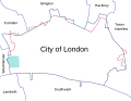
This map shows how the City of London's borders changed before and after 1994.

