
List of Interstate Highways in Alaska facts for kids
   
Shields for Interstates in Alaska
|
|
Quick facts for kids System information |
|
|---|---|
| Formed: | 1976 |
| Length: | 1,082.22 mi (1,741.66 km) |
| Highway names | |
| Interstates: | Interstate A-n (A-n) (unsigned) |
| System links | |
| Alaska Routes | |
The Interstate Highways in Alaska are special roads in the US state of Alaska. The state of Alaska owns and takes care of all these roads. The Alaska Department of Transportation & Public Facilities (DOT&PF) is the group that makes sure these roads are kept in good shape and are safe to use.
There are four main Interstate Highways in Alaska. Together, they stretch for about 1,082.22 miles (1,741.66 km). The longest one is called Interstate A-1 (A-1), which is about 408.23 miles (656.98 km) long. The shortest one is A-3, measuring about 148.12 miles (238.38 km).
It's important to know that these Interstates in Alaska don't have the usual highway signs you might see in other states. This means they are unsigned. People in Alaska usually don't call them by their Interstate numbers like A-1 or A-2. Instead, they use the names of the main highways that make up these Interstates.
What are Alaska's Interstates?
The Interstate Highway System was made bigger to include Alaska in 1976. This happened because of a special law called the Federal-Aid Highway Act of 1976. This law also added Interstates in Puerto Rico.
Unlike many Interstates in the rest of the United States, most of Alaska's Interstates are not big, multi-lane highways. They are often smaller, two-lane roads that go through rural areas. However, some parts of these highways are built to the high standards of other Interstates.
For example, a part of the Seward Highway, which is Interstate A-3, is a modern freeway in Anchorage. The Glenn Highway, part of Interstate A-1, is also a freeway from Anchorage to Wasilla. A small section of the George Parks Highway, which is Interstate A-4, is a freeway in Wasilla. Near Fairbanks, the Richardson Highway, part of Interstate A-2, is also built like a freeway.
Besides these, the Johansen Expressway in Fairbanks and the Minnesota Drive Expressway in Anchorage are also built to a high standard, like expressways.
The Main Interstate Routes
Let's take a closer look at the four Interstate Highways in Alaska:
Interstate A-1
Interstate A-1 is the longest Interstate in Alaska. It starts in Anchorage and goes all the way to the Canadian border near Alcan Border. This route includes parts of several well-known highways: the Glenn Highway, the Richardson Highway, the Tok Cut-Off, and the Alaska Highway. It was established in 1976.
Interstate A-2
Interstate A-2 connects the towns of Tok and Fairbanks. It is about 202.18 miles (325.38 km) long. This Interstate uses parts of the Alaska Highway and the Richardson Highway. Like the others, it was also established in 1976.
Interstate A-3
Interstate A-3 is the shortest of Alaska's Interstates, at about 148.12 miles (238.38 km) long. It runs from Soldotna to Anchorage. This route includes sections of the Seward Highway and the Sterling Highway. It was also established in 1976.
Interstate A-4
Interstate A-4 stretches for about 323.69 miles (520.93 km). It starts near Gateway (which is close to Palmer) and ends in Fairbanks. This entire Interstate is made up of the Parks Highway. It was established in 1976.
Gallery
-
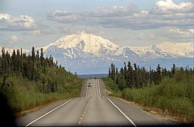
The Glenn Highway, going east near Glennallen, is part of A-1.
-
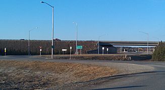
This is an interchange (where roads meet) between the Richardson Highway, part of A-2, and Badger Road in Fairbanks.
-
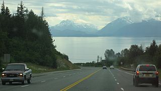
The Sterling Highway, going west near Homer, is part of A-3.
-
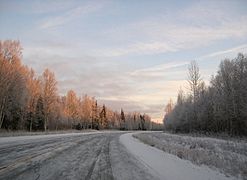
This is the George Parks Highway, which is all of A-4.


See also
