
List of New Rochelle neighborhoods facts for kids
New Rochelle, New York, is a city in Southern Westchester County, right next to the Long Island Sound. It shares its borders with towns like Pelham Manor, Pelham, Eastchester, Scarsdale, Mamaroneck, and Larchmont.
For almost 200 years after it was settled in 1688, New Rochelle was a quiet farming town. But its location near the Sound made it a popular vacation spot by the late 1800s. Wealthy people from New York City came here to relax. In 1889, the Town and Village of New Rochelle officially became one city with about 14,000 people. Just 30 years later, the population grew to over 54,000! New Rochelle became one of the most popular suburban places to live in the country. The city grew quickly, adding new roads and neighborhoods. These early suburbs were very popular with people who worked in the city but wanted to live outside of it. Developers built many beautiful homes and communities on the old farmlands, earning New Rochelle the nickname "City of Homes."
The city's beautiful nature and varied landscape really shaped how it grew, mostly with homes. Today, you can find over fifty "residential parks" here. Some of the most expensive homes in the country are in New Rochelle. For example, the Wykagyl area (zip code 10804) is often on Forbes magazine's list of most expensive zip codes. Homes there can be quite pricey. In the southern part of the city, houses in the fancy waterfront area called Premium Point can cost millions of dollars!
In contrast, the Downtown and South End areas are much more crowded. They have many apartment buildings and tall residential towers. Even so, New Rochelle has more than 11,500 single-family homes. That's more than nearby Larchmont, Mamaroneck, and Scarsdale combined! The city has over 26,000 households in total.
New Rochelle uses several zip codes: 10801, 10802, 10804, 10805, and a few homes are in 10583.
Contents
Exploring New Rochelle's Areas
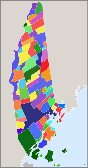
New Rochelle is a city with different parts, each with its own feel. You can explore it on maps: road map • satellite map • terrain map.
Zip Code Areas
- New Rochelle map
- 10801 - maps: road • satellite
- 10804 - maps: road • satellite
- 10805 - maps: road • satellite
- 10583 - maps: road • satellite
Central New Rochelle
This area is located between the North End and Downtown. It's home to some of the city's oldest planned neighborhoods and New Rochelle City Hall. The 10801 zip code covers this entire region.
Glenwood Lake Neighborhood
Glenwood Lake is a neighborhood with smaller homes built in the 1920s and later. It's near the Pelham border. A lot of activity here happens around Daniel Webster Elementary School. This school is a great example of buildings constructed during the 1930s.
Rochelle Park-Rochelle Heights Historic District
This area is so special that it's listed on the U.S. National Register of Historic Places. It includes two neighborhoods:
- Rochelle Heights: This neighborhood was started in 1905 on what used to be a large estate. It has homes of many different sizes.
- Rochelle Park: This area is right behind New Rochelle's City Hall. Part of it was changed when the I-95 highway was built through New Rochelle.
Downtown New Rochelle
The Downtown area is located north of the South End. It's different from other parts of the city because it has mostly apartment buildings and stores, not residential parks. Many new development projects are happening here.
East End of New Rochelle
The East End is generally located east of Downtown. The southern part of this area is a middle-class neighborhood with homes from the early 1900s. It even has the city's only row houses! This area was once owned by inventor John Stephenson. It was also home to workers from the Thanhouser Movie Studios in the early 1900s.
Premium Point: A Gated Community
Premium Point is a very fancy, gated community right on the Long Island Sound. It's partly in New Rochelle and partly in the Town of Mamaroneck. Homes here can be very expensive, ranging from $2 million to $20 million!
Premium Point Park: Waterfront Fun
Premium Point Park is a waterfront community on Echo Bay. It has a dues-paying association that helps maintain common areas like park land, recreational spaces, and docks for water access. It's a great place for outdoor activities by the water.
North End of New Rochelle
The North End is the northern part of New Rochelle. Most of it uses the 10804 zip code, which is the same area as the Wykagyl hamlet. The very northernmost part is in the Scarsdale 10583 zip code.
Bayberry Park: Modern Homes and Nature
Bayberry is an upper-middle-class neighborhood with ranch, split-level, and colonial style homes built in 1954. It was special because it was one of the only new communities in Westchester with its own pools, basketball courts, tennis courts, playground, and clubhouse. Sheldrake Lake and the Leatherstocking Nature Trail are nearby, offering beautiful natural spaces.
Beechmont Neighborhood
The Beechmont neighborhood was planned in 1902 and is centered around Beechmont Lake, which was created by damming Pine Brook. It's on the eastern side of New Rochelle, next to Mamaroneck. Henry Barnard Early Childhood Center, a public school, is located here.
Bonnie Crest: A Planned Community
Development in Bonnie Crest started in 1910 when this area was mostly farmland. It grew because of the New York-Westchester-Boston Railroad line and the nearby Wykagyl station, which made it easy for people to commute.
Ward Acres Homes
This community is next to the Ward Acres forest and nature area. William B. Ward Elementary School is located in this neighborhood.
Daisy Farms: From Farm to Homes
This neighborhood is a 1950s development of single-family homes. It used to be a large working farm called "Great Daisy Farms." The farm was bought in the 1920s to build new homes, but it took many years due to the Great Depression and World War II. In 1951, over 300 ranch-style homes were built here. George M. Davis Elementary School is also in this area.
Paine Heights: Thomas Paine's Land
This neighborhood was developed on 320 acres of land that were given to Thomas Paine for his service in the American Revolution. It became a residential area with large homes and wide streets in the early 1900s. The Thomas Paine Cottage, a museum, is located here.
Pineridge: Homes and Schools
Pineridge is a neighborhood next to Ward Acres and Wykagyl Estates. It has large ranch-style homes built in the 1960s. Albert Leonard Middle School is located in this neighborhood.
Quaker Ridge: A Historic Station
Quaker Ridge is a residential neighborhood along the Scarsdale Village border. The New York, Westchester & Boston Railway built a very nice station here. Its closeness to New York City made it a great spot for commuters.
Southside of New Rochelle
The Southside, or South End, is located west of Echo Bay and south of Downtown. Most of this area is south of Main Street. The 10805 zip code mainly serves the South End.
Residence Park: A Historic Community
Residence Park is a historic residential area planned in the late 1880s. Its historical importance was recognized in 2007. The main campus of the College of New Rochelle is located here.
Sycamore Park: Working-Class Homes
Sycamore Park is a neighborhood developed by the Iselin family to provide affordable homes for the city's working-class population. It has many American Foursquare style homes. The Beechwoods Cemetery and Holy Sepulchre Cemetery are nearby.
West End of New Rochelle
The West End is a small neighborhood known for its smaller building lots and less green space compared to other areas. It's on a hill that used to be called Dutch Hill. This neighborhood has traditionally been home to many immigrant populations, first Italian immigrants and more recently Hispanic immigrants. Montefiore New Rochelle Hospital is located here.
Feeney Park: Community and Education
Feeney Park is a middle-class neighborhood along the Pelham border. It includes a city-owned park of the same name. Columbus Elementary School, which has a science, math, and technology program, is located in this neighborhood.
Hamlets and Special Areas
Cooper's Corner: A Historic Outpost
For over 200 years, Cooper's Corner was an important outpost for people living in Upper New Rochelle, far from the downtown area. It grew around a mill powered by the Hutchinson River and included a general store, a school, and a church.
Davenport Neck: Waterfront Estates
Davenport Neck is a historic waterfront peninsula. It was originally home to Siwanoy Native American tribes. Later, it became a popular summer vacation spot for wealthy New York families who built impressive waterfront estates. Today, it still has upscale residential communities and yacht clubs.
Wykagyl: A Suburban Hub
Wykagyl is a suburban area in the north end of New Rochelle, covered by the 10804 zip code. It has many residential neighborhoods and natural green spaces. Wykagyl also has a small business district with stores, restaurants, and offices that serves as a "Downtown" for many people in the North End. The construction of the New York-Westchester-Boston Railroad in 1912, with its Wykagyl station, helped this area grow into a new residential and business section of the city. The name "Wykagyl" likely comes from an Algonquin Native American tribe that lived in the area long ago.
