
National Register of Historic Places listings in Passaic County, New Jersey facts for kids

Welcome to Passaic County, New Jersey! This area is full of amazing historical places. Many of these spots are so important that they are listed on the National Register of Historic Places. This means they are officially recognized for their special history, architecture, or culture.
Let's explore some of these cool places. They tell stories about how people lived, worked, and built communities long ago. From grand mansions to old factories and beautiful parks, Passaic County has a lot of history to discover!
Contents
- Exploring Passaic County's Historic Gems
- Grand Homes and Estates
- Important Buildings and Structures
- Arch Street Bridge
- Cathedral of St. John the Baptist
- Danforth Memorial Library
- Kossuth Street School
- Passaic County Court House and United States Custom House and Post Office Historic District
- Passaic Elks Club
- Paterson City Hall
- People's Bank and Trust Company Building
- Public School Number Two
- Straight Street Bridge
- Daniel Thompson and John Ryle Houses
- U.S. Animal Quarantine Station
- Parks and Natural Wonders
- Places with Industrial History
- Churches and Religious Sites
- Images for kids
Exploring Passaic County's Historic Gems
Passaic County is home to many buildings and areas that have played a big part in history. These sites are protected so future generations can learn from them. Let's take a closer look at some of the most interesting ones.
Grand Homes and Estates
Many beautiful old houses in Passaic County are now historic landmarks. These homes often belonged to important people or show us how architecture has changed over time.
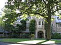
Ailsa Farms (William Paterson University)
The Ailsa Farms estate in Wayne is now part of William Paterson University. The main house, called Haledon Hall, has been beautifully restored and is now known as Hobart Manor. It was listed on the National Register in 1976.
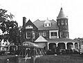
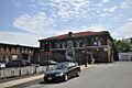
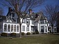
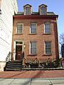
Aycrigg Mansion
The Aycrigg Mansion is a historic home located in Passaic. It stands at Main Avenue and Temple Place. This mansion was added to the National Register in 1982.
Lambert Castle (Belle Vista)
You can find Lambert Castle in Paterson, within the Garret Mountain Reservation. It's officially known as Belle Vista on the Register. This impressive castle was built in 1892 by Catholina Lambert, a silk mill owner. It became a historic site in 1976.
Pietro Botto House
The Pietro Botto House in Haledon is also known as the Pietro and Maria Botto House. This house is super important for labor history in America. It was a meeting place for striking silk workers in 1913. Today, it's the American Labor Museum. It was listed in 1974.
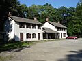
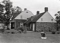
Dey Mansion
The Dey Mansion in Wayne is a very special place. During the American Revolutionary War, George Washington used this house as his headquarters twice. It's a great spot to learn about colonial times. It was added to the Register in 1970.
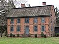
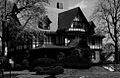
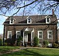
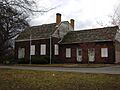
John W. Rea House
The John W. Rea House is located in Hawthorne at 675 Goffle Road. This historic house was listed on the National Register in 1999.
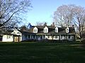
Ringwood Manor
Ringwood Manor is a large historic estate located in Ringwood. It's part of Ringwood Manor State Park. This site has a long history, going back to colonial ironworks. It was recognized as a National Historic Landmark in 1966.
Schuyler-Colfax House
The Schuyler-Colfax House in Wayne is another old home with a rich past. It's found at 2343 Paterson Hamburg Turnpike. This house was added to the National Register in 1973.
Skylands (estate)
Skylands is a beautiful estate located within Ringwood State Park in Ringwood. It features stunning gardens and architecture. It was listed on the National Register in 1990.
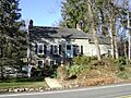
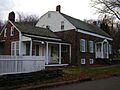
Reynier Speer House
The Reynier Speer House is in Little Falls at 612 Upper Mountain Avenue. This historic home was added to the National Register in 1985.
Van Riper-Hopper House
The Van Riper-Hopper House in Wayne is located at 533 Berdan Avenue. This old house was listed on the National Register in 1972.
John and Anna Vreeland House
The John and Anna Vreeland House is a historic home in Clifton at 971 Valley Road. It was added to the National Register in 1982.
Important Buildings and Structures
Passaic County has many significant buildings, from bridges to city halls, that show off different styles of architecture and important moments in history.
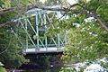
Arch Street Bridge
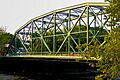
The Arch Street Bridge crosses the Passaic River in Paterson. This bridge is an important part of the city's transportation history. It was added to the National Register in 2018.
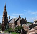
Cathedral of St. John the Baptist
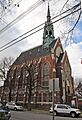
The Cathedral of St. John the Baptist is a grand church located at Main and Grand Streets in Paterson. It's a beautiful example of religious architecture. It was listed in 1977.
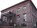
Danforth Memorial Library
The Danforth Memorial Library is a historic building in Paterson at 250 Broadway. This library has served the community for many years. It was added to the National Register in 1984.
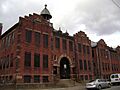
Kossuth Street School
The Kossuth Street School is an old school building in Haledon at 47 Kossuth Street. It represents the history of education in the area. It was listed in 1980.
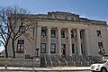
Passaic County Court House and United States Custom House and Post Office Historic District
This historic district in Paterson includes the Passaic County Court House and the former United States Custom House and Post Office. These buildings are important for the county's government and postal history. The district was listed in 2015.
Passaic Elks Club
The Passaic Elks Club building is located at 29-31 Howe Avenue in Passaic. This building has been a community gathering place. It was added to the National Register in 2005.
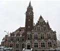
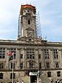
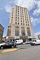
Paterson City Hall
Paterson City Hall is the main government building for the city of Paterson, located at 155 Market Street. It's an impressive building that was listed in 1995.
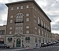
People's Bank and Trust Company Building
The People's Bank and Trust Company Building is located at 663 Main Avenue in Passaic. This historic bank building was added to the National Register in 2018.
Public School Number Two
Public School Number Two is an old school building in Paterson at Mill and Passaic Streets. It was listed on the National Register in 1978.
Straight Street Bridge
The Straight Street Bridge also crosses the Passaic River in Paterson. Like the Arch Street Bridge, it's an important part of the city's infrastructure. It was added to the National Register in 2018.
Daniel Thompson and John Ryle Houses
The Daniel Thompson and John Ryle Houses are two historic homes located at 8 and 9 Mill Street in Paterson. These houses were listed together in 1981.
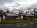
U.S. Animal Quarantine Station
The U.S. Animal Quarantine Station in Clifton was once a place where animals entering the country were checked for diseases. It's located on Clifton Avenue and was listed in 1981.
Parks and Natural Wonders
Passaic County also has beautiful natural areas and parks that are recognized for their historical significance.
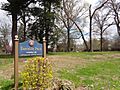
Goffle Brook Park
Goffle Brook Park in Hawthorne is a lovely green space located between Lafayette and MacFarlan Avenues. This park was added to the National Register in 2002.
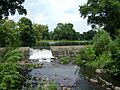
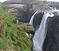
Great Falls of Paterson/S.U.M. Historic District
The Great Falls of Paterson on the Passaic River is a stunning natural waterfall. It's part of a larger historic district that includes the Society for Establishing Useful Manufactures (S.U.M.). This area was key to Paterson's early industrial growth. It was listed in 1970.
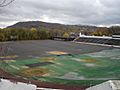
Hinchliffe Stadium
Hinchliffe Stadium in Paterson is a historic sports stadium overlooking the Great Falls. It's famous for hosting Negro league baseball games. It was recognized as a National Historic Landmark in 2004.
Westside Park
Westside Park in Paterson is a historic park located at 114 Totowa Avenue. This park offers green space and recreation for the community. It was listed in 1973.
Places with Industrial History
Passaic County played a big role in America's industrial past, especially with its silk mills and ironworks.
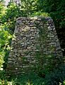
Clinton Furnace
The Clinton Furnace is an old iron furnace located off NJ 23 near Clinton Reservoir in Newfoundland. It's a reminder of early iron production in the area. It was listed in 1976.
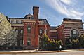
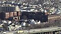
Botany Worsted Mills Historic District
The Botany Worsted Mills Historic District in Passaic includes several buildings that were once part of a large textile mill. This district shows the importance of the textile industry in the region. It was listed in 1991.
Dundee Canal Industrial Historic District
The Dundee Canal Industrial Historic District in Passaic follows the Dundee Canal. This canal was built to power mills and factories. The district highlights the industrial development along the canal. It was listed in 1999.
Long Pond Ironworks
The Long Pond Ironworks is located northeast of West Milford on NJ 511. This site was a major iron-making center for many years. It was listed in 1974.
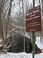
Morris Canal
The Morris Canal was an important waterway that stretched across New Jersey, connecting the Delaware River to the Hudson River. Parts of this historic canal run through Passaic County. It was used to transport coal and other goods. It was listed in 1974.
Paterson Downtown Commercial Historic District
The Paterson Downtown Commercial Historic District includes many buildings in the heart of Paterson. This area was once a bustling center for business and trade. It was listed in 1999.
Reinhardt Mills
The Reinhardt Mills are a collection of buildings in Paterson that were once part of a mill complex. They are located on 21st Avenue, 20th Avenue, Gray Street, and State Street. They were added to the National Register in 2003.
Churches and Religious Sites
Several churches in Passaic County are recognized for their historical and architectural importance.
St. John's Evangelical Lutheran Church
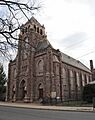
St. John's Evangelical Lutheran Church is located at 140 Lexington Avenue in Passaic. This historic church was listed on the National Register in 1982.
St. Michael's Roman Catholic Church
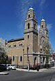
St. Michael's Roman Catholic Church is in Paterson at 74 Cianci Street. This church has been an important part of the community for many years. It was listed in 1978.
St. Nicholas Roman Catholic Church
St. Nicholas Roman Catholic Church is located at Washington, State, and Ann Streets in Passaic. This church was added to the National Register in 1979.
Images for kids
-
Arch Street Bridge over the Passaic River
-
Aycrigg Mansion
-
Botany Worsted Mills
-
Cathedral of St. John the Baptist
-
Clinton Furnace
-
Frederick William Cooke Residence (destroyed)
-
Danforth Memorial Library
-
Dey Mansion
-
Dundee Canal Industrial Historic District
-
Eastside Park Historic District
-
John W. Ferguson House (demolished)
-
Goffle Brook Park
-
Great Falls of the Passaic River
-
Hinchliffe Stadium
-
Kossuth Street School
-
Long Pond Ironworks
-
Morris Canal
-
Passaic County Court House
-
Passaic Elks Club
-
Paterson City Hall
-

Paterson Downtown Commercial Historic District
-
People's Bank and Trust Company Building
-
Public School Number Two
-
John W. Rea House
-
Reinhardt Mills
-
Ringwood Manor
-
Schuyler-Colfax House
-
Skylands
-
Reynier Speer House
-
St. John's Evangelical Lutheran Church
-
St. Michael's Roman Catholic Church
-
St. Nicholas Roman Catholic Church
-
Straight Street Bridge over the Passaic River
-
Daniel Thompson and John Ryle Houses
-
U.S. Animal Quarantine Station
-
Van Riper-Hopper House
-
John and Anna Vreeland House
-
Westside Park


