
List of districts of Andhra Pradesh facts for kids
Quick facts for kids Districts of Andhra Pradesh |
|
|---|---|

Andhra Pradesh Political Map
|
|
| Category | Districts |
| Location | Andhra Pradesh |
| Number | 26 districts |
| Populations | Parvathipuram Manyam – 9,25,340 (lowest); Nellore – 24,69,712 (highest) |
| Areas | Visakhapatnam – 1,048 km2 (405 sq mi)(smallest); Prakasam – 14,322 km2 (5,530 sq mi)(largest) |
| Government | Government of Andhra Pradesh |
| Subdivisions | Revenue Divisions of Andhra Pradesh |
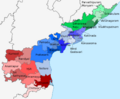
Andhra Pradesh is a state in India, located on the southeastern coast. To help manage the state, it is divided into 26 smaller areas called districts. Think of districts like big counties or regions within a state. These districts are grouped into three main cultural areas: Uttaraandhra, Kostaandhra, and Rayalaseema.
Uttaraandhra includes districts like Srikakulam, Vizianagaram, and Visakhapatnam. Kostaandhra covers a long coastal area with districts such as Kakinada, Guntur, and Nellore. Rayalaseema is an inland region with districts like Kurnool, Anantapur, and Chittoor.
Among all the districts, Visakhapatnam is the smallest in terms of land area. On the other hand, Prakasam is the largest district. When we talk about how many people live there, Sri Potti Sriramulu Nellore district has the most people. The district with the fewest people is Parvathipuram Manyam.
Each district is further divided into smaller parts called revenue divisions. These divisions are then broken down into even smaller areas known as mandals. This helps the government manage services and administration more easily for everyone.
Contents
History of Andhra Pradesh Districts
The number of districts in Andhra Pradesh has changed quite a bit over time. Let's look at how it happened.
Early Days and Andhra State
When India became independent in 1947, the area that is now Andhra Pradesh was part of a larger region called the Madras State. Many people who spoke the Telugu language wanted their own separate state. So, in 1953, the Telugu-speaking areas of Kostaandhra and Rayalaseema were separated from Madras State to form a new state called Andhra State.
At that time, Andhra State had 11 districts. These included Anantapur, Chittoor, East Godavari, Guntur, Krishna, Kurnool, Nellore, Srikakulam, Visakhapatnam, West Godavari, and Kadapa.
Forming United Andhra Pradesh
A few years later, in 1956, the Indian government reorganized states based on the languages people spoke. On November 1, 1956, Andhra State joined with the Telangana region (which was part of the Hyderabad State) to create a bigger state called Andhra Pradesh. This new, combined state is sometimes called "United Andhra Pradesh."
United Andhra Pradesh started with 21 districts, including 10 from the Telangana region. Over the years, some small changes were made to district borders to make administration easier. For example, in 1959, some areas from East Godavari and West Godavari districts were moved to Khammam district because they were closer to it.
Later, two new districts were formed:
- Prakasam district was created in 1970 from parts of Guntur, Nellore, and Kurnool districts.
- Vizianagaram district was created in 1979 from parts of Visakhapatnam and Srikakulam districts.
This brought the total number of districts to 23.
Recent Changes
In 2014, United Andhra Pradesh was divided into two separate states: Andhra Pradesh and Telangana. After this split, the new Andhra Pradesh state had 13 districts. Some tribal areas from Khammam district in Telangana were added to East Godavari and West Godavari districts in Andhra Pradesh as part of the Polavaram Project.
The most recent big change happened in 2022. On April 4, 2022, the Government of Andhra Pradesh created 13 new districts. This nearly doubled the number of districts! Now, Andhra Pradesh has 26 districts, spread across the three cultural regions we talked about earlier: Uttaraandhra, Kostaandhra, and Rayalaseema.
Timeline of Districts
-
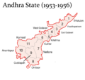
Andhra State (1953–1956)
-
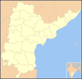
United Andhra Pradesh (1956–2014)
-
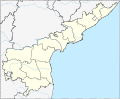
Andhra Pradesh (2014–2022)
-
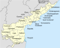
Andhra Pradesh (2022–2023)
-
Andhra Pradesh (2023 - Present)
.png)
.png)


The 26 Districts of Andhra Pradesh
Here is a list of the 26 districts in Andhra Pradesh, along with their main headquarters, population, and area.
| S.No | Official Name | Headquarters | Population | Area (in sq.km) |
Map |
|---|---|---|---|---|---|
| 1 | Srikakulam | Srikakulam | 21,91,471 | 4,591 | .svg) |
| 2 | Parvathipuram Manyam | Parvathipuram | 9,25,340 | 3,659 | .svg) |
| 3 | Vizianagaram | Vizianagaram | 19,30,811 | 4,122 | .svg) |
| 4 | Visakhapatnam | Visakhapatnam | 19,59,544 | 1,048 | .svg) |
| 5 | Alluri Sitharama Raju | Paderu | 9,53,960 | 12,251 | .svg) |
| 6 | Anakapalli | Anakapalli | 17,26,998 | 4,292 | .svg) |
| 7 | Kakinada | Kakinada | 20,92,374 | 3,019 | .svg) |
| 8 | East Godavari | Rajamahendravaram | 18,32,332 | 2,561 | .svg) |
| 9 | Dr. B. R. Ambedkar Konaseema | Amalapuram | 17,19,093 | 2,083 | .svg) |
| 10 | Eluru | Eluru | 20,06,737 | 6,579 | .svg) |
| 11 | West Godavari | Bhimavaram | 18,44,898 | 2,278 | .svg) |
| 12 | NTR | Vijayawada | 22,18,591 | 3,316 | .svg) |
| 13 | Krishna | Machilipatnam | 17,35,079 | 3,775 | .svg) |
| 14 | Palnadu | Narasaraopeta | 20,41,723 | 7,298 | .svg) |
| 15 | Guntur | Guntur | 20,91,075 | 2,443 | .svg) |
| 16 | Bapatla | Bapatla | 15,86,918 | 3,829 | .svg) |
| 17 | Prakasam | Ongole | 22,88,026 | 14,322 | .svg) |
| 18 | Sri Potti Sriramulu Nellore | Nellore | 24,69,712 | 10,441 | .svg) |
| 19 | Kurnool | Kurnool | 22,71,686 | 7,980 | .svg) |
| 20 | Nandyal | Nandyal | 17,81,777 | 9,682 | .svg) |
| 21 | Anantapur | Anantapur | 22,41,105 | 10,205 | .svg) |
| 22 | Sri Sathya Sai | Puttaparthi | 18,40,043 | 8,925 | .svg) |
| 23 | YSR | Kadapa | 20,60,654 | 11,228 | .svg) |
| 24 | Annamayya | Rayachoti | 16,97,308 | 7,954 | .svg) |
| 25 | Tirupati | Tirupati | 21,96,984 | 8,231 | .svg) |
| 26 | Chittoor | Chittoor | 18,72,951 | 6,855 | .svg) |
- Source:
<mapframe width="500" height="500" text="Districts in Andhra Pradesh, zoom and click for interactive identification map" align=center> { "type": "ExternalData", "service": "geoshape", "query": "SELECT ?id ?idLabel (concat('', ?idLabel, '') as ?title) \n WHERE \n { \n ?id wdt:P31 wd:Q1149652 . # is a \n ?id wdt:P131 wd:Q1159 . # in India \n SERVICE wikibase:label { bd:serviceParam wikibase:language 'en' } \n }"} </mapframe>
See also
 In Spanish: Anexo:Distritos del estado de Andhra Pradesh para niños
- List of mandals in Andhra Pradesh
- List of districts in India
- List of revenue divisions in Andhra Pradesh
