List of districts of Karnataka facts for kids
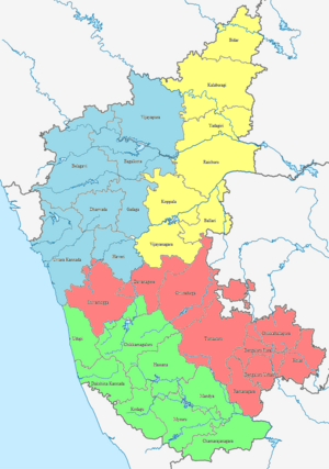
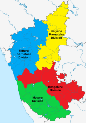
The Indian state of Karnataka is located in South India. It has 31 areas called districts. These districts are grouped into 4 main administrative parts: Belagavi, Bengaluru, Kalaburagi, and Mysore. Karnataka's land has three main types of areas. There is a western coastal stretch along the sea. Then there is a hilly belt with the Western Ghats mountains. Finally, there are the plains which are part of the Deccan plateau.
Contents
History of Karnataka's Districts
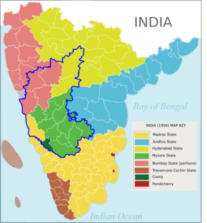
Karnataka as we know it today was formed in 1956. Before that, it was made up of different states and regions. The old states of Mysore and Coorg joined together. Other parts from Bombay, Hyderabad, and Madras also became part of this new state. This was done to create a state where most people spoke the Kannada language. This big change happened because of a law called the States Reorganisation Act of 1956.
The new Mysore State first had ten districts. These included Bangalore, Kolar, Tumkur, and Mysore. Some areas like Ballari had joined Mysore State earlier in 1953. This happened when a new state called Andhra Pradesh was created. Coorg State became Kodagu district. Other areas like South Canara came from Madras State. North Canara, Dharwad, Belagavi, and Vijayapura came from Bombay State. Finally, Bidar, Kalaburagi, and Raichur joined from Hyderabad State. In 1973, the state got its current name, Karnataka.
How New Districts Were Formed
Over time, new districts have been created from existing ones to help with administration. This table shows when some of these new districts were formed:
| Date | New district | Formerly part of | Administration |
|---|---|---|---|
| 15 August 1986 | Bengaluru Urban | Bengaluru | Ramakrishna Hegde's ministry |
| Bengaluru Rural | |||
| 25 August 1997 | Chamarajanagara | Mysuru | J. H. Patel's ministry |
| Davanagere | Chitradurga, Ballari and Shivamogga | ||
| Bagalakote | Vijayapura | ||
| Gadaga | Dharwad | ||
| Udupi | Dakshina Kannada | ||
| Koppala | Raichur | ||
| 21 June 2007 | Ramanagara | Bengaluru Rural | H.D. Kumaraswamy's ministry |
| Chikkaballapura | Kolar | ||
| 30 December 2009 | Yadagiri | Kalaburagi | B.S. Yediyurappa's second ministry |
| 18 November 2020 | Vijayanagara | Ballari | B.S. Yediyurappa's fourth ministry |
How Districts are Managed
Each district in Karnataka is an administrative unit. It is led by a Deputy Commissioner (DC). This officer belongs to the Indian Administrative Service. The Deputy Commissioner is like the chief manager of the district. They are helped by many other officers.
The Superintendent of Police (SP) looks after law and order. This officer is usually from the Indian Police Service. They work to keep the district safe. In big cities like Bengaluru and Mysuru, there are special police chiefs called Commissioners.
Forests, environment, and wildlife in a district are managed by a Deputy Conservator of Forests. This officer is chosen through a special exam. They work to protect nature in the district. Other government departments also have their own heads in each district. These departments handle things like public works, health, and education.
Administrative Divisions of Karnataka
Karnataka's 31 districts are divided into four main administrative divisions. Each division has a group of districts under it. This helps in managing the state more efficiently.
| Belagavi Division | Bengaluru Division | Kalaburagi Division | Mysuru Division |
|---|---|---|---|
|
|
|
|
All Districts in Karnataka
Here is a list of all the districts in Karnataka. Each district has its own main town, called a headquarters. Districts also have smaller parts called 'taluks'. This table also shows when each district was formed, its population, and its area.
Code District Headquarters Established Population(As of 2011[update]) Area Population density(As of 2011[update]) Map BAG
Bagalkote Bagalkote 15 August 1997 1,889,752 6,575 km2 (2,539 sq mi) 288/km2 (750/sq mi) BEU Bengaluru Urban Bengaluru 1 November 1956 9,621,551 2,190 km2 (850 sq mi) 4,393/km2 (11,380/sq mi) BER Bengaluru Rural Bengaluru 15 August 1986 990,923 2,259 km2 (872 sq mi) 431/km2 (1,120/sq mi) BEL Belagavi Belagavi 1 November 1956 4,779,661 13,415 km2 (5,180 sq mi) 356/km2 (920/sq mi) BAL Ballari Ballari 1 November 1956 1,400,970 4,252 km2 (1,642 sq mi) 290/km2 (750/sq mi) BID Bidar Bidar 1 November 1956 1,703,300 5,448 km2 (2,103 sq mi) 313/km2 (810/sq mi) VIJ Vijayapura Vijayapura 1 November 1956 2,177,331 10,498 km2 (4,053 sq mi) 210/km2 (540/sq mi) CHA Chamarajanagar Chamarajanagar 15 August 1997 1,020,791 5,101 km2 (1,970 sq mi) 181/km2 (470/sq mi) CHI Chikkaballapura Chikballapura 10 September 2007 1,255,104 4,524 km2 (1,747 sq mi) 296/km2 (770/sq mi) CHK Chikkamagaluru Chikkamagaluru 1 November 1956 1,137,961 7,201 km2 (2,780 sq mi) 158/km2 (410/sq mi) CHT Chitradurga Chitradurga 1 November 1956 1,659,456 8,440 km2 (3,260 sq mi) 197/km2 (510/sq mi) DAK Dakshina Kannada Mangaluru 1 November 1956 2,089,649 4,560 km2 (1,760 sq mi) 430/km2 (1,100/sq mi) DAV Davanagere Davanagere 15 August 1997 1,643,494 4,460 km2 (1,720 sq mi) 370/km2 (960/sq mi) DHA Dharwad Dharwad 1 November 1956 1,847,023 4,260 km2 (1,640 sq mi) 434/km2 (1,120/sq mi) GAD Gadag Gadag 24 August 1997 1,064,570 4,656 km2 (1,798 sq mi) 229/km2 (590/sq mi) KAL Kalaburagi Kalaburagi 1 November 1956 2,566,326 10,951 km2 (4,228 sq mi) 234/km2 (610/sq mi) HAS Hassan Hassan 1 November 1956 1,776,421 6,814 km2 (2,631 sq mi) 261/km2 (680/sq mi) HAV Haveri Haveri 24 August 1997 1,597,668 4,823 km2 (1,862 sq mi) 331/km2 (860/sq mi) KOD Kodagu Madikeri 1 November 1956 554,519 4,102 km2 (1,584 sq mi) 135/km2 (350/sq mi) KL Kolar Kolar 1 November 1956 1,536,401 3,969 km2 (1,532 sq mi) 386/km2 (1,000/sq mi) KOP Koppal Koppal 24 August 1997 1,389,920 7,189 km2 (2,776 sq mi) 250/km2 (650/sq mi) MAN Mandya Mandya 1 November 1956 1,805,769 4,961 km2 (1,915 sq mi) 364/km2 (940/sq mi) MYS Mysuru Mysuru 1 November 1956 3,001,127 6,854 km2 (2,646 sq mi) 476/km2 (1,230/sq mi) RAI Raichur Raichur 1 November 1956 1,928,812 8,440 km2 (3,260 sq mi) 228/km2 (590/sq mi) RAM Ramanagara Ramanagara 10 September 2007 1,082,636 3,556 km2 (1,373 sq mi) 308/km2 (800/sq mi) SHI Shivamogga Shivamogga 1 November 1956 1,752,753 8,477 km2 (3,273 sq mi) 207/km2 (540/sq mi) TUM Tumakuru Tumakuru 1 November 1956 2,678,980 10,597 km2 (4,092 sq mi) 253/km2 (660/sq mi) UDU Udupi Udupi 25 August 1997 1,177,361 3,880 km2 (1,500 sq mi) 329/km2 (850/sq mi) UTK Uttara Kannada Karwara 1 November 1956 1,437,169 10,291 km2 (3,973 sq mi) 140/km2 (360/sq mi) VIJ Vijayanagara Hospet 18 November 2020 1,353,628 5,644 km2 (2,179 sq mi) 240/km2 (620/sq mi) YAD Yadgiri Yadgiri 30 December 2009 1,174,271 5,234 km2 (2,021 sq mi)
224/km2 (580/sq mi)
See also
- List of taluks of Karnataka
 | Emma Amos |
 | Edward Mitchell Bannister |
 | Larry D. Alexander |
 | Ernie Barnes |


