
Uttara Kannada facts for kids
Quick facts for kids
Uttara Kannada district
|
|
|---|---|
.jpg)   .jpg) .jpg) Clockwise from top-left:Sathodi Fallsin Kanur, Murudeshwar Temple, Kali River Bridge at Karwar, Om Beach at Gokarna, Madhukesvara Temple at Banavasi
|
|
| Nickname(s):
Kashmir of Karnataka
|
|
 |
|
| Country | |
| State | Karnataka |
| Division | Kitturu Karnataka |
| Region | Malenadu & Karavali |
| Established | 1 November 1956 |
| Talukas | Karwar, Ankola, Kumta, Honnavar, Bhatkal, Sirsi, Siddapur, Yellapur, Mundgod, Haliyal, Joida, Dandeli |
| Area | |
| • Total | 10,291 km2 (3,973 sq mi) |
| Area rank | 5th |
| Elevation
Average
|
600 m (2,000 ft) |
| Population | |
| • Total | 1,437,169 |
| • Rank | 20th |
| • Density | 140/km2 (400/sq mi) |
| Languages | |
| • Official | Kannada |
| Time zone | UTC+5:30 (IST) |
| PIN |
581xxx
|
| Telephone code | +91 0(838x) |
| ISO 3166 code | IN-KA |
| Vehicle registration |
|
| Coastline | 142 kilometres (88 mi) |
| Literacy | 84.06% |
| Lok Sabha constituency | Uttara Kannada Lok Sabha constituency |
| Climate | Monsoon (Köppen) |
| Precipitation | 2,835 millimetres (111.6 in) |
| Avg. summer temperature | 33 °C (91 °F) |
| Avg. winter temperature | 20 °C (68 °F) |
Uttara Kannada is a district in the Indian state of Karnataka. It is a large coastal district, the third biggest in Karnataka. It shares borders with Goa and Belagavi to the north. To the east are Dharwad District and Haveri District. Shivamogga District and Udupi District are to the south. The Arabian Sea is to its west.
Karwar is the main office for the district. Kumta and Sirsi are important business centers. The district has two main climate zones. The coastal plain includes areas like Karwar and Bhatkal. The hilly Malenadu region includes Sirsi and Dandeli.
Contents
History of Uttara Kannada
.jpg)


The first known rulers of Uttara Kannada were the Chutus from Banavasi. From 350 to 525 AD, the Kadamba kingdom ruled here from Banavasi. After the Chalukyas took over, other empires ruled the district. These included the Rashtrakutas, Hoysalas, and the Vijayanagar empire.
The famous traveler Ibn Battuta from Morocco is believed to have stayed here. He was protected by Sultan Jamal Al-Din in Hunnur, now called Hosapattana in Honnavar. You can still see old mosque ruins there.
The district was ruled by the Maratha Empire in the 1750s. Later, it became part of the Mysore Kingdom. In 1799, after the Fourth Mysore War, the British took control. It was first part of the Kanara district in Madras Presidency. In 1859, it was split into North and South Kanara districts. The British then moved Uttara Kannada to Bombay Presidency in 1862.
After India became independent in 1947, Bombay Presidency became Bombay State. In 1956, the southern part of Bombay State joined Mysore State. This state was renamed Karnataka in 1972.
The historic Sadashivgad fort is now a popular tourist spot. It stands by the Kali river bridge, where the river meets the Arabian Sea. The famous poet Rabindranath Tagore visited Uttara Kannada in 1882. He wrote a whole chapter about this town in his memories. He stayed with his brother, who was a district judge here. Many Chardo families also moved here from Goa to escape persecution.
Portuguese Influence
Cintacora, also known as Chittakula, was an old port for the Portuguese. When the Sadashivgad fort was built, the village also took its name. Pir fort, named after Shah Karamuddin's Dargah, was burned by the Portuguese in 1510. The Kali River's mouth became a busy trading center. This happened after Sadashivgad was built, as the Portuguese saw the benefits of its safe harbour.
British Presence
In 1638, a British trading group set up a factory in Uttara Kannada. This was in the village of Kadwad, about 6 kilometres (3.7 mi) east on the Kali river. It was a trade port for traders from Arabia and Africa. Baitkhol port, the current civil port, was known for its natural harbor. The name Baitkhol comes from an Arabic term meaning "bay of safety." Muslin was the main item bought here. Other goods included pepper, cardamom, and cotton cloth. In 1649, this group joined the East India Company. Uttara Kannada then became a company factory.

Rule by Mysore Kingdom
In the Treaty of Mangalore in 1784, Uttara Kannada was mentioned. This treaty was signed between Tipu Sultan and the East India Company. Bhatkal and Honnavar were the main ports for Tippu Sultan in the district.
Under the British Empire
The British made Carwar the district headquarters in 1862. From that time, Uttara Kannada was seen as a top-class harbour. It was located between Bombay and Colombo.
Maratha Rule
Uttara Kannada later became part of the Maratha territory. It remained part of the Bombay Presidency until 1950.
Geography and Climate

The main natural feature of the district is the Western Ghats mountain range. This range, also called Sahyadri, runs from north to south. Between the Sahyadris and the sea is a narrow coastal area. This area is called the Payanghat and is about 8 to 24 kilometres (5.0 to 14.9 mi) wide. Behind the coast are flat-topped hills, 60 to 100 meters high. Beyond these hills are the higher ridges and peaks of the Sahyadris.
East of the Sahyadris is the Balaghat upland. This area is part of the large Deccan plateau. Winds carrying moisture come from the west. The yearly rainfall is about 3,000 millimetres (120 in) on the coast. It can be as high as 5,000 millimetres (200 in) on the western slopes of the Sahyadris. East of the mountains, in the rain shadow, rainfall is much less, sometimes only 1,000 millimetres (39 in) a year. Most of the rain falls during the June–September monsoon season.
Four major rivers flow west from the Sahyadris to the sea. From north to south, they are the Kali, Gangawali, Aghanashini, and Sharavati. These rivers create many beautiful waterfalls. The Aghanashini drops 116 meters. Magod Falls sees the Bedti river plunge 180 meters in two steps. Shivganga falls has the Sonda river dropping 74 meters. There are also Lalguli falls and Mailmane falls on the Kali river. In the lowlands, these rivers form wide estuaries that reach several kilometers inland.
Ecology and Wildlife

The district gets a lot of rain, which helps thick forests grow. About 70% of the district is covered by forests. The Malabar Coast moist forests are found in a narrow strip along the Arabian Sea. These forests have mostly been turned into farms and teak tree plantations.
The North Western Ghats moist deciduous forests cover the Sahyadris from 250 to 1000 meters high. Many trees here lose their leaves in the drier months. Above 1000 meters, you find evergreen North Western Ghats montane rain forests.
Anshi National Park near Dandeli protects about 250 square kilometres (97 sq mi) of semi-evergreen forest. This park is home to animals like the tiger, black panther, leopard cat, gaur, Asian elephant, and sambar. It also has many birds and reptiles. Dandeli Wildlife Sanctuary protects 834 square kilometres (322 sq mi) of semi-evergreen and bamboo forests. These forests are in the area where the Kali river and its smaller rivers flow. The Wroughton's free-tailed bat is a special type of bat found only in the forests of Bhimgad Wildlife Sanctuary.
You can also find areas of savanna and degraded scrub jungles. These often appear when forests are overused for logging or grazing. Much of the lower land has been cleared for farming. Mangrove forests grow in the river estuaries. The sandy beaches have groves of Calophyllum inophyllum, coconut trees, and screw pine (Pandanus).
The rocky beaches at Binaga, Arga, Belekeri, Tadadi, Gokarna, Ankola, Kumta, Dhareshwar, Kasarkod, Murdeshwara, Bhatkal, and Belke have many different sea animals. These include creatures from the phyla Porifera, Coelenterata, Annelida, Arthropoda, Mollusca, and Echinodermata. The beaches at Bhatkal include American Jali Beach, Bahrain Jali Beach, NaStar Beach, Nakhuda Beach, Lighthouse Beach, and Udmudey Beach.
Attiveri bird sanctuary is home to 79 types of birds. Some of these birds travel from 22 different countries.
Dandeli Wildlife Sanctuary is famous for the hard-to-spot black panther. Other animals include gaur, tigers, and leopards.
The Kavala caves have a natural Shiva linga about 5 feet (1.5 m) high. Synthery rocks are 500 feet (150 m) high rocks with natural caves and waterfalls. Vincholi rapids and Sykes point offer great views of the Kali river. A suspension bridge is also a place to visit in this sanctuary. Yana is a beautiful place you can reach by trekking about 10 kilometres (6.2 mi) through thick forest. There is also a shrine of Bhairaveshvara here.
Some of the best natural waterfalls in Uttara Kannada District include Burude Falls, about 20 kilometres (12 mi) from Siddapur. Also, Unchalli Falls, Shivgangae, BeeneHolae Fall (about 25 kilometres (16 mi) from Sirsi), Magod Falls, and Sathodi Falls near Yellapura. There are many dams in this district, such as Supa Dam, Kodasalli Dam, and Kadra Dam. The atomic energy station at Kaiga is located on the banks of the Kali River (Karnataka).
Economy and Industry
Uttara Kannada has a Gross Domestic District Product of 530297 Lakh Crores. Karwar and Sirsi are the biggest contributors. Sirsi has the highest income per person in the district.
Agriculture and Farming
The main crops grown in the district are rice and areca nut. Many other crops are also grown. Tree crops include coconut, sugarcane, cocoa, cashew, mango, banana, pineapple, garcinia, jack fruit, and sapota. Vegetables grown here include onion, radish, cucumber, cauliflower, sweet potato, eggplant (brinjal), and amaranth. Spices like pepper, cardamom, ginger, and nutmeg are also important. In the drier eastern part of the district, millet and cotton are grown.
Bhatkal is known for its markets that sell imported goods. These markets existed even before India's economy became more open.
Major Industries
- Kaiga Atomic Power Station
- Solaris ChemTech
- INS Kadamba (Naval Base)
- Supa Dam
- West coast paper mill
People and Culture
| Historical population | ||
|---|---|---|
| Year | Pop. | ±% p.a. |
| 1901 | 454,722 | — |
| 1911 | 430,755 | −0.54% |
| 1921 | 401,928 | −0.69% |
| 1931 | 418,048 | +0.39% |
| 1941 | 441,388 | +0.54% |
| 1951 | 518,062 | +1.61% |
| 1961 | 689,862 | +2.91% |
| 1971 | 849,453 | +2.10% |
| 1981 | 1,073,561 | +2.37% |
| 1991 | 1,220,260 | +1.29% |
| 2001 | 1,353,644 | +1.04% |
| 2011 | 1,437,169 | +0.60% |
| source: | ||
In 2011, Uttara Kannada had a population of 1,437,169 people. This is about the same as the country of Eswatini or the US state of Hawaii. It ranks 346th in India for population. The district has about 140 inhabitants per square kilometre (360/sq mi) people per square kilometer. From 2001 to 2011, the population grew by 6.15%. Uttara Kannada has 975 females for every 1000 males. About 29.15% of the people live in cities.
Religions in Uttara Kannada
| Religion in Uttara Kannada district (2011) | ||||
|---|---|---|---|---|
| Religion | Percent | |||
| Hinduism | 82.61% | |||
| Islam | 13.08% | |||
| Christianity | 3.10% | |||
| Buddhism | 0.89% | |||
| Other or not stated | 0.32% | |||
Most people in the district are Hindu. There has been a Catholic community here since the 1500s. Muslims are a large group in Bhatkal Taluk and are the majority in Bhatkal City. A small group of Tibetan refugees lives in Mundgod.
Languages Spoken
The main language spoken in this district is Kannada, by 55.34% of the people. Other major languages include Konkani (18.21%), Urdu (11.83%), Marathi (9.52%), and Telugu (1.36%). Marathi speakers are mostly in Joida and Haliyal areas. Konkani is common in Karwar and other parts of the district. Nawayathi is a Konkani dialect spoken by Nawayath Muslims in Bhatkal.
Most people in Uttara Kannada understand Kannada, even Konkani speakers. However, in some villages in northern Karwar, like Sadashivgad, people mainly speak Konkani because they are close to Goa. Kannada dialects spoken here include Achchagannada or Halakki Kannada and Havigannada. The Nawayath men wear special lungis.
Education and Literacy
About 1.08 million people in the district can read and write. Around 580,000 are male and 500,000 are female. The literacy rate (for people over 6 years old) in Uttara Kannada is 84%. This means 90% of males and 78% of females are literate. The overall literacy rate has gone up by 7%. Male literacy increased by 5%, and female literacy increased by 10%.
| Rank | Taluk | Literacy |
|---|---|---|
| 1 | Sirsi | 94% |
| 2 | Karwar | 89% |
| 3 | Kumta | 87% |
| 4 | Ankola | 85% |
| 5 | Siddapur | 85% |
| 6 | Honnavar | 84% |
| 7 | Dandeli | 83% |
| 8 | Bhatkal | 83% |
| 9 | Yellapur | 81% |
| 10 | Mundgod | 80% |
| 11 | Joida | 76% |
| 12 | Haliyal | 74% |
Arts and Literature

Yakshagana is a traditional dance drama popular in Karnataka. It is especially well-known in Uttara Kannada. This art form combines music, songs, dance, acting, dialogue, and unique costumes. The songs and dances follow specific rhythms, similar to Indian classical dance. However, the acting and dialogues are often made up on the spot by the artists. This mix of classical and folk styles makes Yakshagana very special. It is sometimes called an "opera" in Western terms.
Traditionally, Yakshagana shows started late at night and lasted until morning. The Bagavatha, who sings in the background, also directs the story. They control everything happening on stage. The Bagavatha and musicians who play chande and maddale form the himmela (background group). The actors wear colorful costumes and play different roles. They form the mummela (front group). Many professional groups perform Yakshagana in Karnataka. Even with movies and TV, these groups still perform and make a profit.
Yakshagana is sometimes simply called aata in Kannada and Khela in Konkani, both meaning "play." Yaksha-gana literally means "song of a yaksha." Yakshas were a special group mentioned in ancient Indian literature.
Literary Works
Many writers have contributed to the literature of this region. Some notable names include Karki Venkataramanasastri Suri, Gaurisha Kaikini, and Jayantha Kaikini. Early newspapers from the district include Havayaka Subodha (1885) and Karvara Chandrika (1885). Children's Newspaper Hitopadesh (1888) was also published. Later, newspapers like Kanada Dhurina (1922) and Nandini (1925) were started.
Local Cuisine

Uttara Kannada is famous for its many delicious seafood dishes. Fish curry and rice are a common meal for locals. Cashews and coconut are also used a lot in cooking.
The usual meal includes steamed rice with a vegetable or seafood dish. Seafood is very popular because it's easy to find. It's prepared with many local spices. Tea is the most popular drink. Sometimes, cardamom or mint is added to give it a special taste.
Here are some local dishes:
- Kotte Kadubu: A dessert made from jackfruit pulp and jaggery. The batter is steamed in a container and served hot with ghee.
- Holge: Sweet flatbreads. One type is made with gram flour and jaggery, another with coconuts.
- Todadevu: A thin-crust dosa made from jaggery or sugarcane juice. Many local desserts in Sirsi use jaggery instead of sugar.
- Shira: Rice cooked with sugar, ghee, and semolina.
- Karakali: A spicy chutney made from colocasia leaves.
- Kotte Roti: An idli-like dish, steamed in a cone shape made from jackfruit leaves.
- Patrode: A special dish made by steaming stuffed colocasia leaves.
- Neer Dose: A soft, thin pancake made from boiled rice batter, coconut milk, and salt.
- Kajmiji
- Koli Kajjaya and Hosagere Kajjaya: Made from rice flour and fried. Often served with potato sambar or chicken curry.
- Banana Buns
- Hanchina Rotti
- Ankola Koli Saaru
- Appe Huli
- Patholi
- Kalali Masala
- Genasle
- Tambli
Transportation
Public Transport
The North West Karnataka Transport Corporation (NWKRTC) manages public transport in the district. It connects all towns and villages. There are regular bus services to major cities like Bangalore, Mangalore, and Mysore. Buses from the neighboring Goa state also connect Karwar to Mangalore and other parts of Goa. Kumta, Bhatkal, and Sirsi are key hubs for public transport.
Many private buses also offer services within and outside the state. Bhatkal is a major area for private transport. National Highway 66 passes through the district, connecting Panvel near Mumbai to Kerala. Many private buses use this highway for services to places like Bombay, Poona, and Mangalore.
Railways
Several railway lines run through the district:
- The Konkan Railway connects Mangalore and Mumbai. It passes through Kumta, Bhatkal, and Karwar.
- The Londa to Vasco Railway line goes through Castle Rock.
- There is a railway line from Castle Rock to Dandeli.
- A new railway line from Hubli to Ankola is planned. It will connect Karwar port to northern Karnataka.
- Another proposed line from Honnavar to Talaguppa, Shimoga, will link Karwar port to central Karnataka.
- The Sirsi to Haveri railway line is planned to connect the Malnad region.
- A line from Sirsi to Siddapur and Talaguppa, Shimoga, is proposed to link to Shimoga.
- RO-RO (Roll on/Roll off) services are available from Ankola railway station to Suratkal Railway station. Many truckers use this to transport goods between Ankola and Mangalore.
Ports and Harbors
Uttara Kannada is a coastal district in Karnataka with a coastline of 120 kilometres (75 mi). It has many ports used for sea trade, naval bases, fishing, and other sea activities.
- Karwar Port is a medium-sized seaport. It handles large ships, coastal shipping, and fishing boats. Ships can also refuel here.
- Karwar Airport will be built by the Indian Navy at Alageri village. This naval air base is part of the Navy's large Project Seabird.
- INS Kadamba is a naval base at Arga village near Karwar. It is used only for naval ships. It also has a ship repair yard.
- Belkeri Port is an anchorage port.
- Tadri Port is a fishing port.
- Kumta Port is a fishing port.
- Honnavar Port is a fishing port.
- Bhatkal Port is a fishing port. There is also another fishing port called Tengingundy Port.
The proposed Hubli-Ankola railway line could help develop the district's ports. It would allow easier movement of goods. Currently, roads are the main way goods are moved, which can cause traffic on the National Highways.
Nearby Airports
- Goa International Airport
- Mangalore International Airport
- Hubli Airport
- Belgaum Airport
Tourist Attractions
Uttara Kannada (North Kanara) has many places for tourists. There are religious sites like Gokarna, Murudeshwar, Idagunji, and Ulavi. The district has many beaches at Karwar, Gokarna, Bhavikeri near Ankola, Murdeshwar, Harawada, Kadle beach near Kumta, and Handigon.
Anshi National Park (Kali Tiger Reserve) is located in Uttara Kannada. The calm waters behind the dams on the Kali river offer beautiful views, especially during the rainy season. These dams are at Kadra, Thattihalla, Kodasalli, Supa, and Bommanahalli.
There are many waterfalls in Uttara Kannada district. Some of them are Sathodi, Devkar, Emme shirle, Arebail, Benne Hole, Unchalli, Burude, and Balepatte.
Notable People from Uttara Kannada
- Justice Dr. S. R. Nayak, former Chief Justice of Karnataka High Court
- Ramakrishna Hegde, who served as Chief Minister of Karnataka twice
- S. M. Yahya, former Finance Minister of Karnataka
- Dr. Sannappa Parameshwar Gaonkar, Deputy Chief Minister in Bombay State
- Venkanna H. Nayak, a lawyer and former Commissioner
- Dr. N. K. Nayak, Professor Emeritus at IIT Bombay
- Anant Nag, actor
- Shankar Nag, actor and director
- Yashwant Chittal, writer
- Shantinath Desai, writer
- Chittani Ramachandra Hegde, Yakshagana artist
- Gurudas Kamat, politician
- Major Rama Raghoba Rane, awarded the Param Veer Chakra
- Jayshree Gadkar, Marathi movie actress
- Dinakara Desai, writer
- Gourish Kaikini, author and teacher
- Narayan Hosmane, scientist
- Jayant Kaikini, writer
- Leena Chandavarkar, actress
- Nandan Nilekani, businessman
- Pandari Bai, actress
- Sundar Nadkarni, writer
- Vilas Sarang, writer
- Keremane Shivarama Hegde, Yakshagana artist
- Mynavathi, Kannada Actress
- R N Shetty, industrialist
- Anuradha Paudwal, singer
- Radhika Pandit, actress
Images for kids
-
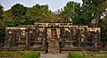
Chaturmukha Basadi, Gerusoppa built by Chennabhairadevi, a long-reigning Indian queen.
-
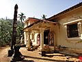
Kodlamane Shree Vishnumurthy Temple
-
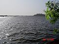
Kali River and Sadashivgad Fort from Nandangadda Village.
-
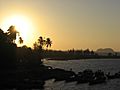
Karwar evening
-
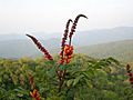
Candy corn plant in the Anshi National Park
-
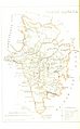
North Kanara, 1896
-
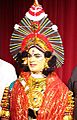
Costume of yakshaghana
-
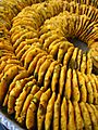
Batata Vada
See also
 In Spanish: Distrito de Uttara Kannada para niños
