
Livermore Falls, Maine facts for kids
Quick facts for kids
Livermore Falls, Maine
|
|
|---|---|

Bank Building in downtown Livermore Falls
|
|

Location of Livermore Falls (in yellow) in Androscoggin County and the state of Maine
|
|

Livermore Falls, Maine
Location in Maine
|
|
| Country | United States |
| State | Maine |
| County | Androscoggin |
| Villages | Livermore Falls East Livermore |
| Area | |
| • Total | 20.42 sq mi (52.89 km2) |
| • Land | 19.68 sq mi (50.97 km2) |
| • Water | 0.74 sq mi (1.92 km2) |
| Population
(2020)
|
|
| • Total | 3,060 |
| • Density | 60.2/sq mi (23.2/km2) |
| ZIP Codes |
04254 (Livermore Falls)
04228 (East Livermore) |
| Area code(s) | 207 |
| Website | lfme.org |
Livermore Falls is a town in Androscoggin County, Maine, in the United States. In 2020, about 3,060 people lived there.
This town is part of the larger Lewiston-Auburn area in Maine. Students from Livermore Falls attend Spruce Mountain High School.
Contents
History of Livermore Falls
The area where Livermore Falls is located was once home to the Abenaki Native American people. They called it Rockemeka, which means "great corn place."
In 1771, the land was given to soldiers who fought in a battle against Port Royal in 1710. The first English settlers arrived in 1786. In 1795, the area became a town called Livermore, named after Deacon Elijah Livermore.
The Androscoggin River divided the town, creating two parts. The part east of the river became its own town called East Livermore in 1844. Later, in 1929, East Livermore was renamed Livermore Falls.
Early Industries and Growth
In the early 1800s, Livermore Falls was mostly farmland. Farmers grew apples and raised dairy cows, selling their products in nearby cities like Boston and Portland.
As time went on, new industries grew. Mills that used water power from the local waterfalls became important. These mills processed grain and cut lumber. When the Androscoggin Railroad arrived in 1852, Livermore Falls grew into a small mill town.
Factories that made shoes and paper mills were built. One famous paper mill was the Umbagog Pulp Company. In 1897, a very long bridge called the Third Bridge was built across the Androscoggin River. It was 800 feet long, making it the longest single-span bridge in New England at that time.
-
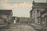
Depot Street in 1909
-
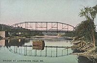
Third Bridge in 1909
-
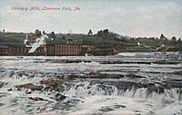
Umbagog Mills in 1909


Geography and Climate
Livermore Falls covers about 20.42 square miles (52.89 square kilometers). Most of this area is land, and a small part is water. The town is drained by the Androscoggin River.
Weather in Livermore Falls
Livermore Falls has a humid continental climate. This means it has big changes in temperature throughout the year. Summers are warm to hot and can be humid. Winters are cold, and sometimes very cold.
Population Information
The population of Livermore Falls has changed over the years. Here's how many people lived there during different census counts:
| Historical population | |||
|---|---|---|---|
| Census | Pop. | %± | |
| 1890 | 963 | — | |
| 1930 | 3,148 | — | |
| 1940 | 3,190 | 1.3% | |
| 1950 | 3,359 | 5.3% | |
| 1960 | 3,343 | −0.5% | |
| 1970 | 3,450 | 3.2% | |
| 1980 | 3,572 | 3.5% | |
| 1990 | 3,455 | −3.3% | |
| 2000 | 3,227 | −6.6% | |
| 2010 | 3,187 | −1.2% | |
| 2020 | 3,060 | −4.0% | |
| U.S. Decennial Census | |||
2010 Census Details
In 2010, there were 3,187 people living in Livermore Falls. There were 1,316 households, which are groups of people living together in one home.
Most of the people in town (96.1%) were White. A small number of people were from other racial backgrounds. About 2.2% of the population was Hispanic or Latino.
About 33.9% of households had children under 18 living with them. The average age of people in Livermore Falls was about 38.1 years old.
Transportation

The Bowman Field airport is located about 5 miles (7 kilometers) southeast of the center of Livermore Falls.
Education
Livermore Falls is part of a school district called RSU 73. This district includes the towns of Jay, Livermore, and Livermore Falls.
Before 2010, Livermore Falls had its own high school. But in 2010, the school district joined with Jay Schools. The high schools in both towns were renamed Spruce Mountain High School. The mascots also changed from the Tigers and Andies to the Spruce Mountain Phoenix.
Livermore Falls Middle School closed in 2011. Its students and teachers moved to the new Spruce Mountain Middle School, which is in the old Jay Middle School building.
Notable People
Some well-known people have come from Livermore Falls:
- Kevin Bailey, a politician from Texas.
- Louise Bogan, a famous poet and critic.
- Herbert Elijah Wadsworth, a businessman.
See also
 In Spanish: Livermore Falls (Maine) para niños
