Loch Scridain facts for kids
Quick facts for kids Loch Scridain |
|
|---|---|

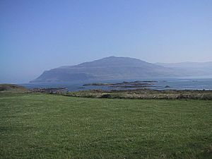
View from Knockan
|
|
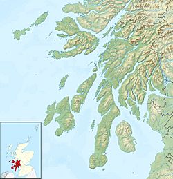
| Location | Isle of Mull, Scotland |
| Coordinates | 56°21′59″N 6°05′03″W / 56.36639°N 6.08417°W |
| Basin countries | United Kingdom |
Loch Scridain is a beautiful sea loch located on the Isle of Mull in Scotland. It stretches about 15 kilometers (9 miles) long. This amazing loch faces the Atlantic Ocean on the western coast of Mull. It's part of the Inner Hebrides, a group of islands off the west coast of Scotland.
Exploring Loch Scridain's Geography
Loch Scridain reaches far inland towards Ben More. This is the Isle of Mull's only Munro, which is a Scottish mountain over 3,000 feet (914 meters) tall. Ben More is also an extinct volcano and a huge massif, which means a large mountain mass. It sits on the Ardmeanach peninsula to the north. A tall hill called Bearraich stands guard over the loch's entrance.
To the south, you'll find the Ross of Mull. This is the longest peninsula on Mull, stretching out into the Atlantic Ocean. Near the very end of Loch Scridain is a small piece of land called the Aird of Kinloch. This land almost separates the main loch from a smaller inner sea loch, called Loch Beg. The River Coladoir flows into Loch Beg.
At Kilfinichen Bay, there's a place called Seabank Villa. This spot is important because it's where the mineral mullite was first discovered and studied.
Villages Around Loch Scridain
Loch Scridain has three small settlements along its shores. These are Tiroran, Kilfinichen, and Pennyghael. Together, they have a total population of about 60 people. The A849 road runs along the southern side of the loch. This road leads to Bunessan and Fionnphort. In Pennyghael, you can turn off the main road to reach Carsaig Bay.
The Amazing Geology of Loch Scridain
The area around Loch Scridain and the Ardmeanach peninsula is a fascinating lava landscape. This means the land was formed by ancient lava flows. These flows created a layered look, almost like a giant cake. The lava here is mostly basalt, which is rich in minerals. This makes the land between the rocky areas very green and fertile.
You can see black basalt rocks, which are sometimes stained orange. The orange color shows where the top surfaces of the lava flows were weathered. This happened about 60 million years ago, when the climate was tropical!
There's even a fossil tree to discover. It has a cave next to it and a large boulder below on the shore. Nearby, you can see a small area of columnar basalt. This is where the lava cooled into tall, pillar-like shapes. The fossil tree is a hollow half-cylinder, about 4 feet (1.2 meters) wide, starting just above the ground. Just past the tree, there's a black sand beach. You can also spot older boulders in the basalt shoreline. These boulders were covered by the lava flow 60 million years ago.
 | Victor J. Glover |
 | Yvonne Cagle |
 | Jeanette Epps |
 | Bernard A. Harris Jr. |


