Lockrose facts for kids
Quick facts for kids LockroseQueensland |
|||||||||||||||
|---|---|---|---|---|---|---|---|---|---|---|---|---|---|---|---|

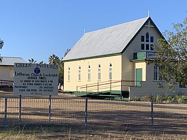
Green Pastures Lutheran Church, 2019
|
|||||||||||||||
| Population | 564 (2021 census) | ||||||||||||||
| • Density | 35.92/km2 (93.0/sq mi) | ||||||||||||||
| Postcode(s) | 4342 | ||||||||||||||
| Area | 15.7 km2 (6.1 sq mi) | ||||||||||||||
| Time zone | AEST (UTC+10:00) | ||||||||||||||
| Location | |||||||||||||||
| LGA(s) |
|
||||||||||||||
| State electorate(s) | Lockyer | ||||||||||||||
| Federal Division(s) | Blair | ||||||||||||||
|
|||||||||||||||
Lockrose is a small rural area in Queensland, Australia. It's located in two different regions: the Lockyer Valley Region and the Somerset Region. In 2021, about 564 people lived there.
Contents
Where is Lockrose?
Lockrose is found in the south-east part of Queensland. To the north, you'll find Lockyer Creek. Brightview Road forms the southern edge of the area.
Even though it's not officially a town, Lockrose has a central area. This is where the school, church, and other useful places are located. This main part is surrounded by homes. There's also another small group of homes in the south of Lockrose.
Areas near the creek are used for farming many different crops. Other rural lands are used for grazing animals on natural plants.
A Look at Lockrose's Past
Lockrose has a history that goes back over a hundred years. Important places like the school and church opened in the early 1900s.
School History
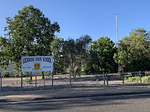
The Lockrose Provisional School first opened its doors on March 20, 1905. A few years later, on January 1, 1909, it became known as Lockrose State School. It has been teaching students ever since!
Church History
The Green Pastures Lutheran Church opened in November 1909. Pastor Millat led the first service. Around 350 people came to the opening, including the children from the school. They even got a holiday to attend!
People said it was the biggest celebration Lockrose had ever seen. The church building was made of wood and measured about 30 by 20 feet. It cost about £136, which included the fencing. The church was completely paid for when it opened.
Post Office
Lockrose also had its own Post Office. It opened around 1913, though a smaller "receiving office" had been there since 1906. The Post Office served the community for many years before closing in 1972.
Who Lives in Lockrose?
The number of people living in Lockrose has stayed quite steady over the years.
- In 2011, there were 553 people.
- In 2016, the population grew slightly to 562 people.
- By 2021, the population was 564 people.
Learning in Lockrose
Lockrose State School is a government primary school. It teaches boys and girls from Prep (the first year of school) up to Year 6. You can find the school at 17 Zabel Road.
In 2017, the school had 64 students. There were 5 teachers and 9 other staff members who helped run the school.
There are no high schools directly in Lockrose. The closest government high school is Lowood State High School, which is located in Lowood.
Community Places
The Green Pastures Lutheran Church on Zabel Road holds services every Sunday. There is also a cemetery located behind the church.


